A New Beginning
Hikes #71 & #72
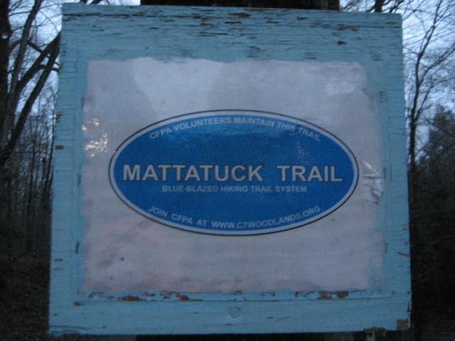
Mattatuck Trail
Peterson Park (Wolcott, CT) to Town Hill Road Access Trail (Plymouth, CT) .:. Hiked 12/7/2013
Distance: 13+ Miles Round Trip (6.65 Miles One Way)
Town Hill Road Access Trail (Plymouth, CT) to Reynolds Bridge (Thomaston, CT) .:. Hiked 12/8/2013
Distance: 12+ Miles Round Trip (6.52 Miles One Way)
Date Published: 12/13/2013
Hikes #71 & #72
Mattatuck Trail
Peterson Park (Wolcott, CT) to Town Hill Road Access Trail (Plymouth, CT) .:. Hiked 12/7/2013
Distance: 13+ Miles Round Trip (6.65 Miles One Way)
Town Hill Road Access Trail (Plymouth, CT) to Reynolds Bridge (Thomaston, CT) .:. Hiked 12/8/2013
Distance: 12+ Miles Round Trip (6.52 Miles One Way)
Date Published: 12/13/2013
Hike #71
According to local legend, the greater Waterbury area was once known as Mattatuck. Before that, it was reportedly called Matetacoke by the Algonquin Indians. Matetacoke, which supposedly translates to “place without trees” probably doesn’t sound like a good place for a hike…but, as I set out on my journey along the Mattatuck Trail, I’m so far finding this “place without trees” to be quite enjoyable.
Once I finished up the Quinnipiac Trail on Hike # 70, I started looking at new trails which were long enough to last several hikes and would allow me to close out my “365 miles in 365 days” goal, which I originally started to consider way back in December of last year. As I searched for trails I’ve yet to travel, I came across a trail which would allow me to hike to some of Connecticut’s higher peaks. I knew those peaks would come later…but, once I saw how some of the elevations would take me higher than my previous CT highest, it was a no-brainer…it was time to start working on the Mattatuck Trail.
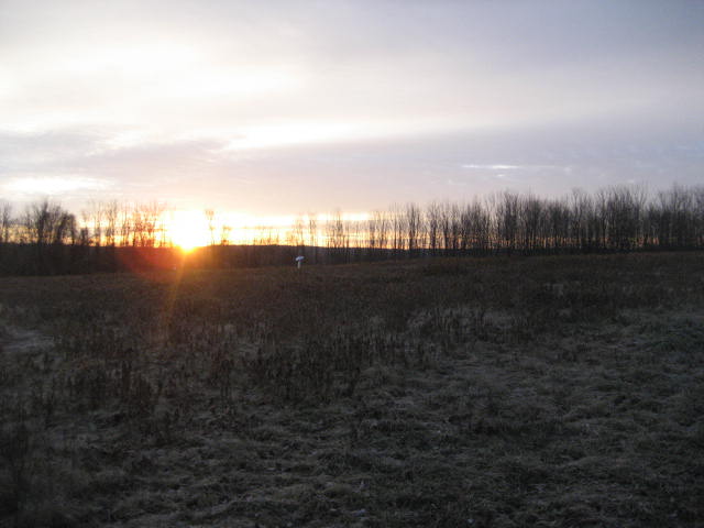
Upon completion, the Mattatuck Trail (at 36 miles) will be the sixth long-distance trail I’ve completed. For now, it begins in its own humble little way, just behind a skate park within Peterson Park in Wolcott. There is plenty of parking here, but a sign in the area advises the park doesn’t open until 8am. I got lucky when I arrived shortly before 7am and the gate was already open. I parked, got Roscoe (making his first hike in a few weeks after his injury) out of the car, and we hit the trail.
Once I finished up the Quinnipiac Trail on Hike # 70, I started looking at new trails which were long enough to last several hikes and would allow me to close out my “365 miles in 365 days” goal, which I originally started to consider way back in December of last year. As I searched for trails I’ve yet to travel, I came across a trail which would allow me to hike to some of Connecticut’s higher peaks. I knew those peaks would come later…but, once I saw how some of the elevations would take me higher than my previous CT highest, it was a no-brainer…it was time to start working on the Mattatuck Trail.
Upon completion, the Mattatuck Trail (at 36 miles) will be the sixth long-distance trail I’ve completed. For now, it begins in its own humble little way, just behind a skate park within Peterson Park in Wolcott. There is plenty of parking here, but a sign in the area advises the park doesn’t open until 8am. I got lucky when I arrived shortly before 7am and the gate was already open. I parked, got Roscoe (making his first hike in a few weeks after his injury) out of the car, and we hit the trail.
Starting out, the trail is pretty wide. The first mile or so is pretty flat and it generally follows alongside the Mad River. I imagine this area gets pretty wet in the rainy months, but I only had to contend with a minimal amount of mud and water from a few days of rain earlier in the week. There are several bridge crossings, which cross the Mad River near an area of small falls and “rapids”, through this early section.
Around the one mile mark, we came to the foundation of an old milldam. I took some pictures but, because it was still early, they didn’t come out…and I forgot to take back-ups later in the day on our way back to the car. Shortly after the milldam, the trail comes out to a power line cut. I have to say that this was one of the more interesting power line cuts I’ve ever experienced in that there was a lot of running water. I don’t know if the trail is always like this, or if it was like this because of the recent rain, but it was a different experience. After the power line cut, the trail follows a dirt road for a bit before re-entering the woods. At this point, the trail starts to head uphill but it isn’t long before it descends to cross Spindle Hill Road (at the 1.8 mile mark).
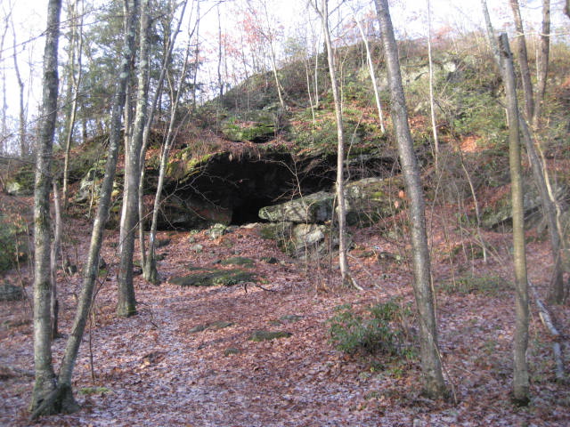
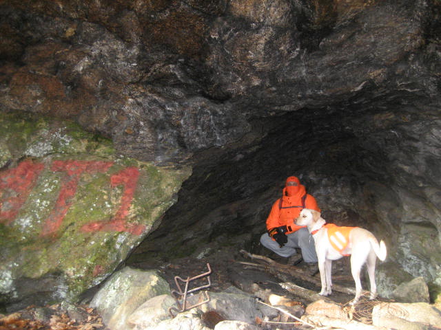
On the other side of Spindle Hill Road, the trail ascends again but it quickly enters some hilly terrain with several ups and downs (nothing overly steep). It also leaves Wolcott behind and enters the town of Plymouth. At the 2.6 mile mark, the Walk Book notes Charlie Krug Cave. And, later (around the 2.8 mile mark) it notes Indian Jack Cave. I took the pictures below, of what I believe is Indian Jack Cave, the second of the two “caves” noted in the Walk Book. If the pictures of Indian Jack Cave don’t say “cave” to you, then I’m afraid you’re only going to be even more disappointed by Charlie Krug Cave…as I didn’t even consider it to be worthy of a picture. Also, I can see where people would walk right by Charlie Krug Cave and not even realize it was there. Of the two “caves”, Indian Jack Cave is definitely cooler, but it didn’t change my life.
On the other side of Spindle Hill Road, the trail ascends again but it quickly enters some hilly terrain with several ups and downs (nothing overly steep). It also leaves Wolcott behind and enters the town of Plymouth. At the 2.6 mile mark, the Walk Book notes Charlie Krug Cave. And, later (around the 2.8 mile mark) it notes Indian Jack Cave. I took the pictures below, of what I believe is Indian Jack Cave, the second of the two “caves” noted in the Walk Book. If the pictures of Indian Jack Cave don’t say “cave” to you, then I’m afraid you’re only going to be even more disappointed by Charlie Krug Cave…as I didn’t even consider it to be worthy of a picture. Also, I can see where people would walk right by Charlie Krug Cave and not even realize it was there. Of the two “caves”, Indian Jack Cave is definitely cooler, but it didn’t change my life.
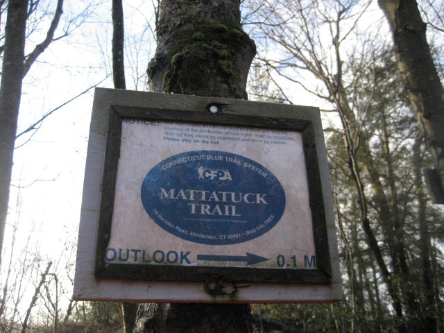
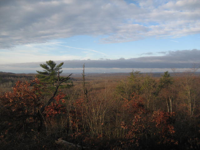
Shortly after exploring Indian Jack Cave, Roscoe and I set back out on the trail. Not too far from the cave, there is a side trail which leads to an overlook. The map in the Walk Book labels this trail as B/Y (Blue/Yellow) but the trail is blazed White. The view from the overlook isn’t great, but I wasn’t expecting a single view on this hike so it was a nice surprise.
About three and half miles in, we passed a marshy pond (Marino Pond) and made our way out to Wolcott Road. The next 6/10 of a mile is all road walk. From Wolcott Road, the trail makes a right on Allentown Road. We took advantage of a sidewalk and, as much as I detest road walks, they really do help when you are trying to cover mileage quickly. They are even more helpful when you consider that later, when you are exhausted but have to double back, you’ll get a chance to catch your breath on the flat ground…at least that’s what I told myself on this hike.
Around the 4.1 mile mark, the trail makes a left and leaves Allentown Road behind. Here, the trail follows someone’s private driveway…this always intrigues me. I love hiking these trails, but I’m not sure how I’d feel about one as part of my driveway. I hope to eventually live near one, but I don’t even want it cutting through my yard. My driveway? Forget about it.
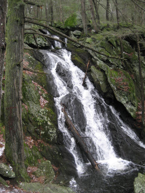
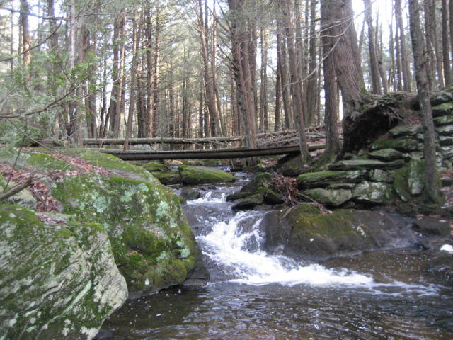
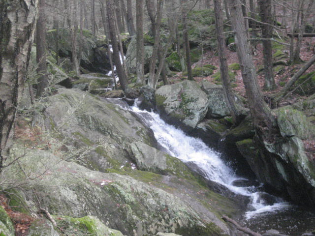
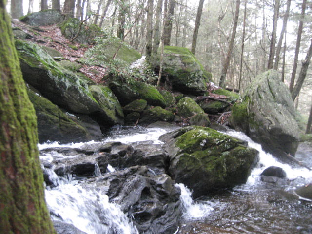
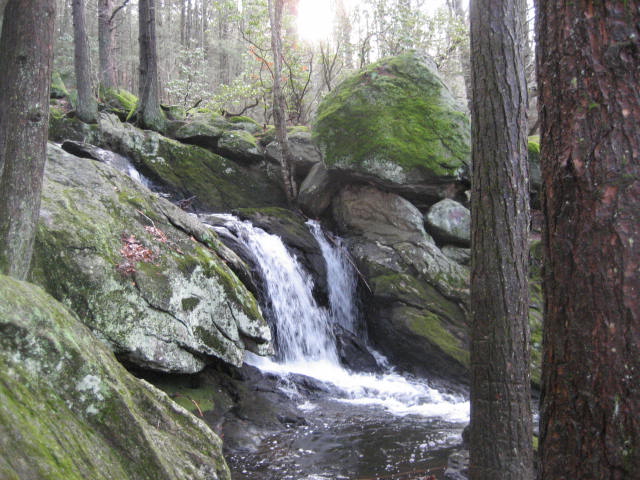
The trail eventually turns right and re-enters the woods near Buttermilk Falls. In my previous hike recap, I recounted my disappointment with the “waterfalls” of CT. But, as with that hike, I was pleasantly surprised by these falls. David Ellis, over at Connecticut Waterfalls (http://www.ctwaterfalls.com/), has done some research on the waterfalls in CT and he has the following statistics for Buttermilk Falls: 59 feet high, 99 gallons a second…which is impressive. If numbers don’t impress you, take a look at my pictures below. If you still aren’t impressed, I encourage you to go check them out. There is an alternate parking location not too far from the bottom of the falls so you don’t even need to do four miles of hiking to get there. I can't think of any excuse NOT to visit what I consider to be one of Connecticut’s hidden gems.
Around the 4.1 mile mark, the trail makes a left and leaves Allentown Road behind. Here, the trail follows someone’s private driveway…this always intrigues me. I love hiking these trails, but I’m not sure how I’d feel about one as part of my driveway. I hope to eventually live near one, but I don’t even want it cutting through my yard. My driveway? Forget about it.
The trail eventually turns right and re-enters the woods near Buttermilk Falls. In my previous hike recap, I recounted my disappointment with the “waterfalls” of CT. But, as with that hike, I was pleasantly surprised by these falls. David Ellis, over at Connecticut Waterfalls (http://www.ctwaterfalls.com/), has done some research on the waterfalls in CT and he has the following statistics for Buttermilk Falls: 59 feet high, 99 gallons a second…which is impressive. If numbers don’t impress you, take a look at my pictures below. If you still aren’t impressed, I encourage you to go check them out. There is an alternate parking location not too far from the bottom of the falls so you don’t even need to do four miles of hiking to get there. I can't think of any excuse NOT to visit what I consider to be one of Connecticut’s hidden gems.
|
|
Around the 4.7 mile mark, the trail comes out to Lane Hill Road, of which a portion is closed in the winter. We passed the alternate parking location I mentioned earlier and started another lengthy road walk. At the corner of Lane Hill Road and South Main Street, the trail makes a left but then quickly turns right on South Eagle Street. Here, it crosses over a couple of bridges (over Hancock Brook and then a railroad track). It follows South Eagle Street for about 4/10 of a mile before making a left and re-entering the woods.
The final 9/10 of a mile wasn’t very interesting. The trail follows what looks like an old creek bed through an area adjacent to the Mattatuck State Forest. There are several unmarked side trails (a theme which would continue the following day) and evidence of ATV traffic in the area. Eventually (at the 6.1 mile mark), I came to an intersection with a Blue/White access trail. To the right, roughly half of a mile from the intersection, is a parking location just off of Town Hill Road. I decided this intersection of trails was a good stopping point for my first Mattatuck hike. Section One = Complete.
The final 9/10 of a mile wasn’t very interesting. The trail follows what looks like an old creek bed through an area adjacent to the Mattatuck State Forest. There are several unmarked side trails (a theme which would continue the following day) and evidence of ATV traffic in the area. Eventually (at the 6.1 mile mark), I came to an intersection with a Blue/White access trail. To the right, roughly half of a mile from the intersection, is a parking location just off of Town Hill Road. I decided this intersection of trails was a good stopping point for my first Mattatuck hike. Section One = Complete.
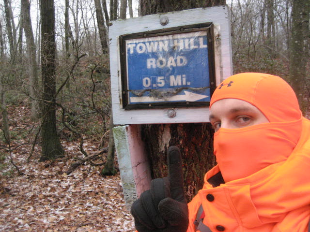
Of course, I still had to hike all the way back (another 6.1 miles). But, before I started on my way back, I wanted to check out the parking location off of Town Hill Road. Recalling the sign at Peterson Park which advised the park doesn’t usually open until 8am, I wanted to make sure I wasn’t planning to arrive at Town Hill Road too early the following morning. After making my way over the next half mile, I was happy to see there was no gate and no stated restrictions for how early one could park at this location.
From the lot, I made my way back to Peterson Park. But, I have to admit to taking some small short-cuts and, without adding any extra side trails, the true distance back to my car was less than 6.65 miles. So, instead of giving myself credit for 13.3 miles, I’m only taking 13. How honest of me, right?
From the lot, I made my way back to Peterson Park. But, I have to admit to taking some small short-cuts and, without adding any extra side trails, the true distance back to my car was less than 6.65 miles. So, instead of giving myself credit for 13.3 miles, I’m only taking 13. How honest of me, right?
Hike # 72
The following morning, Roscoe and I were up early and we made our way back to the parking location off of Town Hill Road. We made our way through the field near the parking location, following the Blue/White blazes of the access trail, until we arrived at the intersection of the Mattatuck (roughly half a mile).
The next section of the Mattatuck Trail enters a portion of the Mattatuck State Forest. The Mattatuck State Forest, which covers roughly 4,000 acres of land, is probably most-famous for The Leatherman’s Cave, which I will explore on a future hike and write about in a future recap. This section of the Mattatuck State Forest doesn’t have any caves I’m aware of, but there is a “Big Pebble”…more on that in a moment.
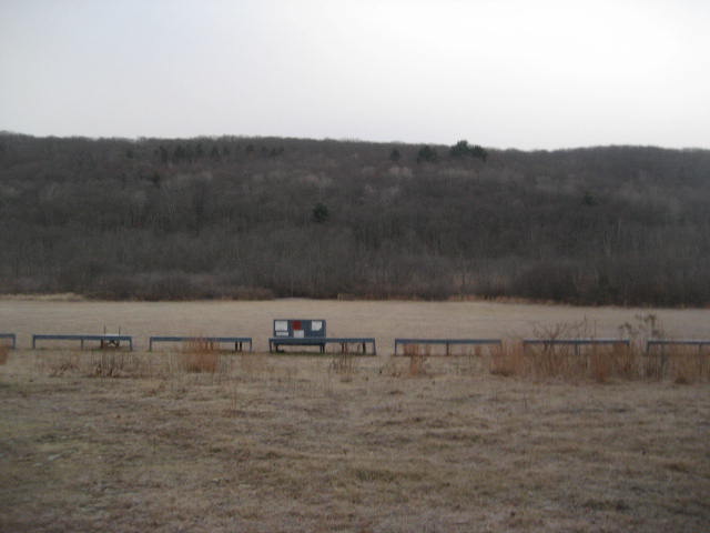
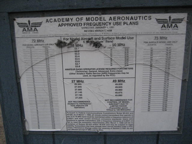
Around the 1.25 mile mark, as I was descending to Todd Hollow Road, I noticed a large open field which...from a distance...looked almost like a salt flat. Knowing of no such salt flats in CT, my curiosity was piqued. Once I reached the road, I noticed a side trail (Blue/Red Blazed) which would lead me to the field. But, this trail went in the opposite direction from the Mattatuck. After a few second, my curiosity won out and I decided to check out the field. What I found still baffles me even as I type this. And, it only proves that you never know what you are going to find on these hikes. Ready for this? The field along Todd Hollow Road is used by the Academy of Model Aeronautics. Essentially it is a “runway” for remote control airplanes. How cool is that?
The next section of the Mattatuck Trail enters a portion of the Mattatuck State Forest. The Mattatuck State Forest, which covers roughly 4,000 acres of land, is probably most-famous for The Leatherman’s Cave, which I will explore on a future hike and write about in a future recap. This section of the Mattatuck State Forest doesn’t have any caves I’m aware of, but there is a “Big Pebble”…more on that in a moment.
Around the 1.25 mile mark, as I was descending to Todd Hollow Road, I noticed a large open field which...from a distance...looked almost like a salt flat. Knowing of no such salt flats in CT, my curiosity was piqued. Once I reached the road, I noticed a side trail (Blue/Red Blazed) which would lead me to the field. But, this trail went in the opposite direction from the Mattatuck. After a few second, my curiosity won out and I decided to check out the field. What I found still baffles me even as I type this. And, it only proves that you never know what you are going to find on these hikes. Ready for this? The field along Todd Hollow Road is used by the Academy of Model Aeronautics. Essentially it is a “runway” for remote control airplanes. How cool is that?
A few more steps down Todd Hollow Road and I came to what I believe is the "Ed’s Big Pebble" referred to in the Walk Book.
At this point, I turned back around and followed Todd Hollow Road back to where I originally left the Mattatuck. I rejoined the trail and followed it out to Keegan Road. Along the way, Todd Hollow Road follows the edge of Hancock Brook Lake, which is part of a network of flood-control properties in the area managed by the U.S. Army Corp of Engineers. I made a left on Keegan Road and another quick left to re-enter the woods. Here the trail heads back in the opposite direction alongside the western edge of the marsh created by Hancock Brook Lake.
The next section of the Mattatuck, which leads away from Keegan Road and to South Street, is very challenging. The terrain isn’t very tough, but there are several side trails which make it easy to lose the Mattatuck (later, on the trip back, I lost my way for a bit). Make sure to keep an eye out for the Blue Blazes. But, don't forget to check out the seasonal views of Brophy Pond.
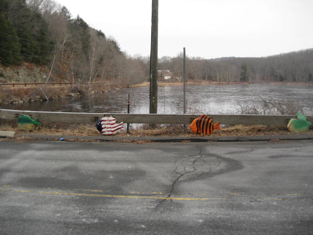
At the 3.7 mile mark of my hike (which would be about the 3.5 mile mark if you avoid the side trail to Ed’s Big Pebble and the AMA field), the trail reaches South Street and turns left. It was time for another road walk. The trail follows South Street for about 2/10 of a mile, before making a right to follow Wilton Road. Half a mile later, the trail turns left and follows Carter Road. Near the intersection of Wilton and Carter roads, there is a pond (Wilton Pond) and the edge of the pond has neat fish statues…again, you never know what you will find…
The next section of the Mattatuck, which leads away from Keegan Road and to South Street, is very challenging. The terrain isn’t very tough, but there are several side trails which make it easy to lose the Mattatuck (later, on the trip back, I lost my way for a bit). Make sure to keep an eye out for the Blue Blazes. But, don't forget to check out the seasonal views of Brophy Pond.
At the 3.7 mile mark of my hike (which would be about the 3.5 mile mark if you avoid the side trail to Ed’s Big Pebble and the AMA field), the trail reaches South Street and turns left. It was time for another road walk. The trail follows South Street for about 2/10 of a mile, before making a right to follow Wilton Road. Half a mile later, the trail turns left and follows Carter Road. Near the intersection of Wilton and Carter roads, there is a pond (Wilton Pond) and the edge of the pond has neat fish statues…again, you never know what you will find…
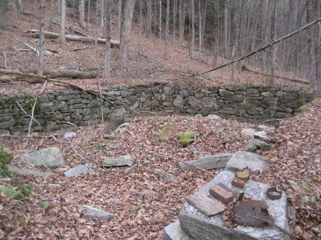
After the left on Carter Road, the trail makes a right and re-enters the woods. Not far from the road, the trail enters Thomaston and passes by an old foundation…I love these things!
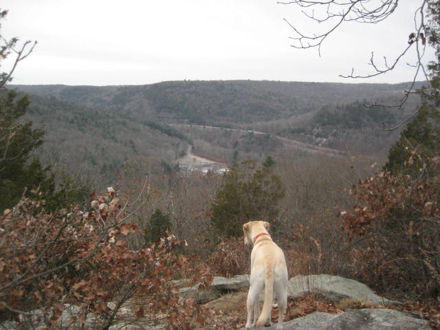
Take a minute to catch your breath here, because the trail climbs for pretty much the next half mile, and it is a 230 foot elevation change. The reward for making the climb is a viewpoint overlooking Route 8.
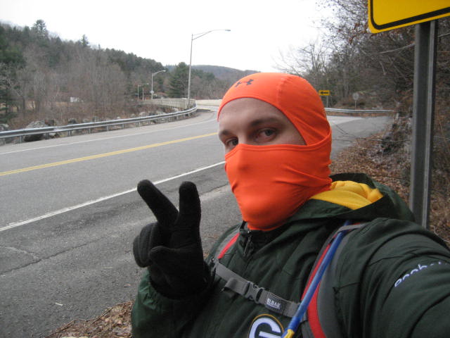
Roscoe and I spent a few minutes enjoying the overlook, but then we made our way back along the trail, which now descends steeply back down the other side of Cedar Mountain until it comes to Waterbury Road. Here, the trail turns right and follows the road for about a quarter of a mile before turning right on West Hill Road. I found the next section of trail more than just a little frustrating. It re-enters the woods off of West Hill Road and heads almost straight uphill. Since it will eventually turn again and head back to Waterbury Road, there is absolutely no reason for it to ever leave the road. It is only about a quarter of a mile, and you can still see/hear the road the whole time. Normally, I wouldn’t complain about avoiding a road walk but this one seemed pointless to me, especially at the end of a 6.5 mile hike. I did my best to hide my frustration as I took my “Section Two = Complete” photo.
As with the day before, I stuck to the trail most of the way back. But, I was able to cut out the extra mileage spent earlier on some of the side trails and take advantage of a few small shortcuts (some of which were unintentional). So, I’m not giving myself credit for the full 13 miles. Instead, I’m only taking credit for 12 miles…even though I’m probably short-changing myself. Regardless, I just logged 25+ miles in one weekend and I’m continuing to close in on my 2013 goal. Will I make it? Stay tuned to find out…
Distance to 2013 Goal: 33.53 Miles
Distance to 2013 Goal: 33.53 Miles
