Bushwhacked
Hike #63
Trail(s): Quinnipiac Trail (Banton Street to Sleeping Giant State Park)
Town(s): North Haven, CT and Hamden, CT
Distance: 7.60 miles
Date Hiked: 11/11/2013
Date Published: 11/13/2013
Hike #63
Trail(s): Quinnipiac Trail (Banton Street to Sleeping Giant State Park)
Town(s): North Haven, CT and Hamden, CT
Distance: 7.60 miles
Date Hiked: 11/11/2013
Date Published: 11/13/2013
Note: I am closing in on completion of the Sleeping Giant State Park Trails. As I’ve indicated in the past, I will publish a full recap for all of those trails once I’m done. In order to complete them, I need to complete the section of the Quinnipiac Trail which runs through the park. And, in order to stay true to my “complete every long-distance trail in order from start to finish”; I had to complete this section of the Quinnipiac Trail first.
As I was planning this hike, I came across a lot of information…some of it good, some of it bad…all of it important.
For starters, you should know that the first four miles of this trail run mostly parallel to the Quinnipiac River…and the area is prone to flooding. In fact, the area floods so often that an area neighborhood was abandoned and demolished. Now, the area is called what the Walk Book refers to as a “disturbance community”…which basically means the natural balance between native and non-native plant species has been disrupted. It also means there are a lot of poison ivy and pricker bushes. So many, in fact, that the Walk Book recommends planning this hike for the cooler months.
Also, the Walk Book at the start of the Quinnipiac Trail section includes an interesting note about why the blazes on most of our trails in CT are blue. In short, Rev. Edgar Laing Heermance (who served as the first Chairman of the Connecticut Forest & Parks Association Trails Committee from 1929 to 1936…and later served as Secretary for 12 years) is the man behind the blue blazes. Way back in 1929, Heermance is said to have spent an evening sitting on his front porch staring at different color blazes painted on the trees of his property. Instead of enjoying the sunset, Mr. Heermance was conducting an experiment to see which color of paint shows best at dusk. In the end, the light blue color won out.
Honestly, until I read that, I never gave the color of the blazes that much thought. They were always just that certain shade of light blue. I only choose them as part of the name for my site because I thought it was cool to parallel a slang term for someone who is a novice to the color of most of the blazes. Now that I know the history and the reason for their light blue color, I’ll never look at them the same again.
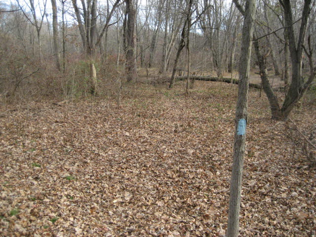
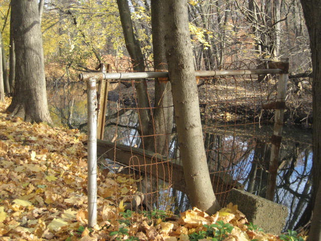
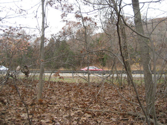
Veteran’s Day 2013 was a near-perfect cool clear day in Connecticut. Since it was November, I figured the situation with the poison ivy and pricker bushes would be under control. However, I wasn’t willing to risk too much and decided it was probably best to leave Roscoe at home. This would prove to be a wise decision on my part. As you might be able to tell from the picture above, there were many sections where the trail just disappears into overgrowth.
The first section of the Quinnipiac Trail starts on Banton Street in North Haven. The parking location suggested by the Walk Book is actually right behind a rest stop on the Merritt Parkway, just north of exit 63…
As I was planning this hike, I came across a lot of information…some of it good, some of it bad…all of it important.
For starters, you should know that the first four miles of this trail run mostly parallel to the Quinnipiac River…and the area is prone to flooding. In fact, the area floods so often that an area neighborhood was abandoned and demolished. Now, the area is called what the Walk Book refers to as a “disturbance community”…which basically means the natural balance between native and non-native plant species has been disrupted. It also means there are a lot of poison ivy and pricker bushes. So many, in fact, that the Walk Book recommends planning this hike for the cooler months.
Also, the Walk Book at the start of the Quinnipiac Trail section includes an interesting note about why the blazes on most of our trails in CT are blue. In short, Rev. Edgar Laing Heermance (who served as the first Chairman of the Connecticut Forest & Parks Association Trails Committee from 1929 to 1936…and later served as Secretary for 12 years) is the man behind the blue blazes. Way back in 1929, Heermance is said to have spent an evening sitting on his front porch staring at different color blazes painted on the trees of his property. Instead of enjoying the sunset, Mr. Heermance was conducting an experiment to see which color of paint shows best at dusk. In the end, the light blue color won out.
Honestly, until I read that, I never gave the color of the blazes that much thought. They were always just that certain shade of light blue. I only choose them as part of the name for my site because I thought it was cool to parallel a slang term for someone who is a novice to the color of most of the blazes. Now that I know the history and the reason for their light blue color, I’ll never look at them the same again.
Veteran’s Day 2013 was a near-perfect cool clear day in Connecticut. Since it was November, I figured the situation with the poison ivy and pricker bushes would be under control. However, I wasn’t willing to risk too much and decided it was probably best to leave Roscoe at home. This would prove to be a wise decision on my part. As you might be able to tell from the picture above, there were many sections where the trail just disappears into overgrowth.
The first section of the Quinnipiac Trail starts on Banton Street in North Haven. The parking location suggested by the Walk Book is actually right behind a rest stop on the Merritt Parkway, just north of exit 63…
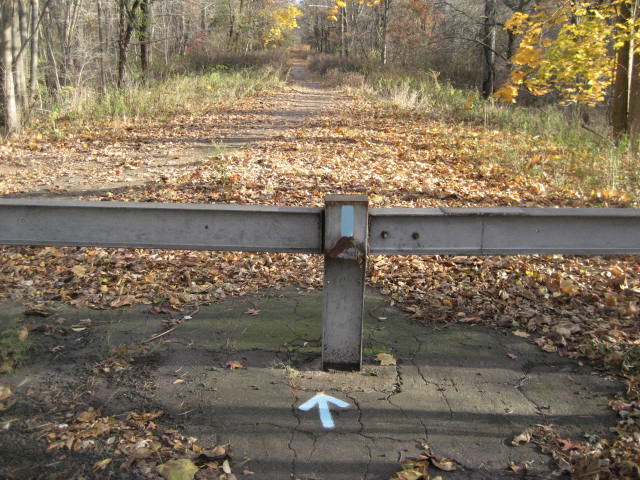
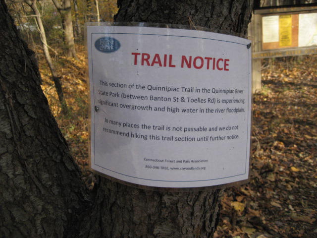
In addition to running along the Quinnipiac River, the first four miles of the trail runs mostly parallel to the Merritt Parkway. Here, at the trailhead, there is a guard rail and the overgrowth situation looks to be under control. But, there are signs posted by the CFPA describing the trail as "not passable" in many places…
|
|
The first mile or so of the hike wasn’t bad at all. In fact, I was surprised (given all the warning signs) there was a trail here at all. I made my way through the old Banton Street Neighborhood, taking some pictures along the way…
|
|
Heading north along the trail, with the Merritt Parkway on my left and the Quinnipiac River on my right, I soon came to realize the sign posted by the CFPA at the trailhead was for real. Hiking quickly turned to bushwhacking and fun quickly turned to dread when I realized I was going to have to crash my way through down tree branches and underbrush for four miles…and I might have to do it again coming back the other way in order to get back to my car. Somewhere along the way, I decided that just wasn’t going to happen. I would fight my way through this stuff in order to make it the better sections I knew were coming, but I would have to find another way back to my car.
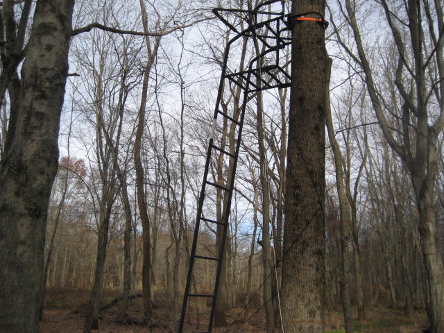
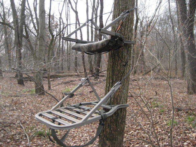
I’m still not 100% certain how much of the actual Quinnipiac Trail I covered, but I did my best to follow the blue blazes where I could and make my way back to them whenever I got re-routed around a thicket of brush. This was a living nightmare. I’ve done more physically challenging hikes before, but I’ve never encountered anything so mentally taxing in all of my hikes. Fortunately, there was evidence of hunters in the area (never thought I’d say that) and I was able to use the clearings where there were hunting stands to cover ground a lot more quickly…
I’m still not 100% certain how much of the actual Quinnipiac Trail I covered, but I did my best to follow the blue blazes where I could and make my way back to them whenever I got re-routed around a thicket of brush. This was a living nightmare. I’ve done more physically challenging hikes before, but I’ve never encountered anything so mentally taxing in all of my hikes. Fortunately, there was evidence of hunters in the area (never thought I’d say that) and I was able to use the clearings where there were hunting stands to cover ground a lot more quickly…
|
|
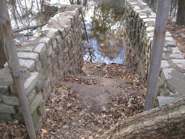
After two and a half miles of suffering, I finally came to the approach of Toelles Road. Here, the trail begins to reform and I was able to follow the blazes as the trail maintainers originally planned. As it nears the road (around the four mile mark), the trail actually ascends a hill and runs quite close to the Merritt Parkway. I was able to get a picture of some cars flying by at 65 mph…
The trail then descends to Toelles Road and makes a left turn to go under the Merritt Parkway. The Walk Book notes another parking location in this area (where Toelles Road intersects with Old Hartford Turnpike), but I’ve yet to see anything that looks like a good parking area…and I’ve spent most of the last six weeks down this way while hiking Sleeping Giant. When it reaches Old Hartford Turnpike, the trail makes another left (heading south) and continues as a road walk for about 1/10 of a mile. Then, it crosses Old Hartford Turnpike and enters Sleeping Giant State Park...
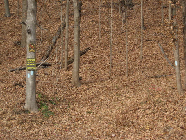
I’ve spent a lot of time in recent weeks working my way through the sections of trail within Sleeping Giant (again, a full report is coming…I promise) but this is the first time I’ve been this far north in the park. In this section of the park, section VII, the Blue (Quinnipiac) Trail is the only trail. It starts by heading up a pretty steep hill (250 feet gain over the course of a little more than a mile) and curving back to the north, heading back in the opposite direction of which I had just come. Near the top, the trail bends to the left and straddles the town line between Hamden and Wallingford. It was nice to be hiking and not bushwhacking.
5.4 miles into my hike, I reached Chestnut Lane and I was getting closer to familiar territory. On my first hike along the Sleeping Giant Trails, I crossed this section of the trail while driving to the Chestnut Lane parking area. So, I knew my next point of reference would be the Yellow Trail and, about 2/10 of a mile later, I found it.
Originally, the Yellow Trail was to be my turn around point. I was going to double back and cover the entire 5.6 miles back the other way. After what I experienced during the first few miles of this hike, I knew that wasn’t going to happen. So, since it was a clear day, I decided to keep hiking on the Quinnipiac Trail and find some views to enjoy.
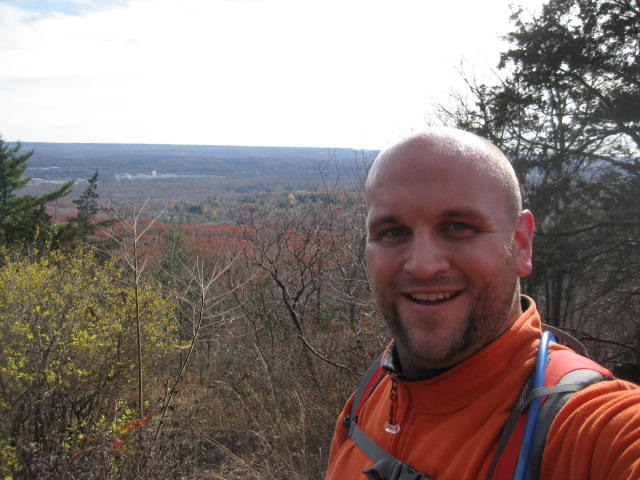
After climbing another 340 feet uphill, I came to a really nice view. I had seen this view before (while travelling the White Trail a few weeks earlier), but I decided to stop and enjoy it again. I figured after all the miles I spent bushwhacking through the forest which I was now overlooking, I earned it…
5.4 miles into my hike, I reached Chestnut Lane and I was getting closer to familiar territory. On my first hike along the Sleeping Giant Trails, I crossed this section of the trail while driving to the Chestnut Lane parking area. So, I knew my next point of reference would be the Yellow Trail and, about 2/10 of a mile later, I found it.
Originally, the Yellow Trail was to be my turn around point. I was going to double back and cover the entire 5.6 miles back the other way. After what I experienced during the first few miles of this hike, I knew that wasn’t going to happen. So, since it was a clear day, I decided to keep hiking on the Quinnipiac Trail and find some views to enjoy.
After climbing another 340 feet uphill, I came to a really nice view. I had seen this view before (while travelling the White Trail a few weeks earlier), but I decided to stop and enjoy it again. I figured after all the miles I spent bushwhacking through the forest which I was now overlooking, I earned it…
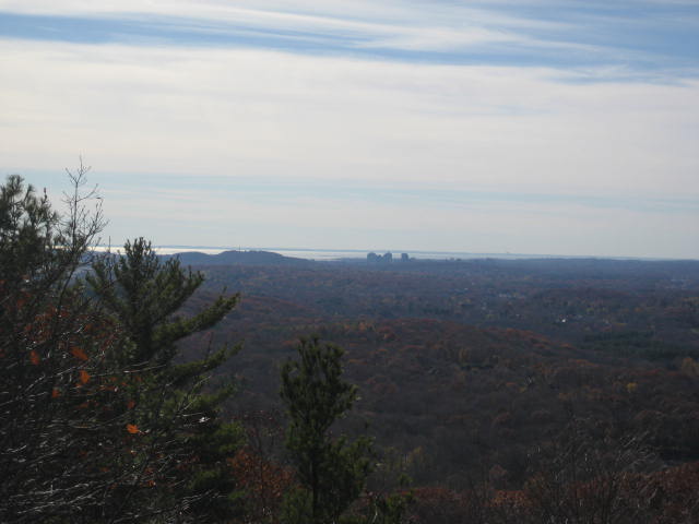
After I caught my breath, I decided to see just how hard I could push myself. I wanted to try and re-cover as much of the White Trail as possible before I called it quits. So, I made a left turn and followed that trail for about 8/10 of a mile. I enjoyed some more views along the way, including one of downtown New Haven (with Long Island Sound in the background)…
I descended one particularly steep section of the White Trail (more on that in my Sleeping Giant recap), up again to another view along the White Trail, and finally decided I'd had enough. Once I reached the Green/Yellow Connector Trail, I decided to follow that down the ridgeline to the Yellow Trail. I followed the Yellow Trail due west to the Red Triangle Trail and followed that out to Mount Carmel Avenue, passing by some Quinnipiac students who were smoking pot.
Reaching paved surface, I saved/turned off my Map My Hike app and started to bring up me Google Maps app in order to try and find a way back to my car. In the meantime, I noticed a text from Jaci (about an hour old at this point) asking me if I was done hiking…haha. Instead of texting her back, I decided to call and ask her to look up the best route on an actual computer. I think she thought I was calling to ask for a ride, but she was at work and I was determined to see this through (no more emergency exits…haha). Eventually, she confirmed what I feared. The road walk back to my car would require another 3 miles out of me. I was spent, but I made it (about an hour later).
All in all, 7.6 miles of hiking…and 3.1 miles of walking…not bad for a day’s work.
Take my advice…don’t do the first section of this hike until you see some kind of official word from the good folks over at the CFPA advising the trail conditions are improved…that section of the trail just isn’t worth the grief and aggravation. I think it is meant to be a lazy stroll along the river…and, at least for now, it most definitely is not…
Distance to 2013 Goal: 144.70 miles
