Hike #13
Trail: Shenipsit
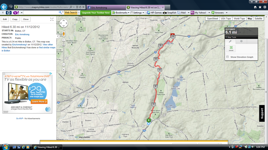
Section: Rt. 44 Commuter Lot (Bolton, CT) to I-84 Commuter Lot (Vernon, CT)
Distance: 6.3 miles
Approximate time to complete: 3 hours
Direction of travel: South to North
Date Hiked: 11/12/2012
Date Published: 1/1/2013
After my second day of hiking the Gay City State Park Trails, I was exhausted. But, I had already planned to hike for a third straight day on the following day. So, we drove out to the commuter lot off of I-84 (Exit 67) and left my car there overnight.
The next morning, the day of this hike, I was still sore. But, as sore I was, it was clear that Roscoe was twice as sore. I know him, and I don’t doubt that he would have come with me, but I could tell his legs were too sore for what I had planned. So, as much as I could tell he wanted to come along, I made the decision to leave him at home.
Jaci was kind enough to drop me off at the Rt. 44 Commuter Lot (near Bolton Notch) on her way to work. This was out of the way for her so it meant a lot that she was willing to do it.
Those of you who are familiar with the area know that Bolton Notch is where I-384 ends and it splits into either Rt. 44 or Rt. 6. Most of you have probably seen the rock on top of the cliffs painted like the American flag. What you probably don’t know, and I didn’t until I started researching this hike, is that on the other side of the pond/lake/marsh from the flag rocks is an abandoned drive in theater. Luckily for me, I would no longer have to just read about the drive in as the trail starts out by passing it.
The abandoned drive-in thing sounds cool but this one is kind of a miss. At this point, after years of decay, it really is just the metal frame of the projection screen. And, the lot where you used to watch the movies from, is overgrown with a lot of trees. Not a problem, trees are good...but there is also a lot of trash in and around the trees. I would be lying to you if I told you I wasn’t expecting some vagrants to pop out at any minute. But, this hike eventually gets a lot better…I promise.
The next half mile or so is fairly flat. At the end of the half mile, the map in the CFPA Walk Book notes a view from the north side of Bolton Notch Pond. I can see where people would be disappointed with this view. You aren’t at a very high elevation so you are basically just overlooking the pond and staring straight at what you can only assume is a better view (from atop the "flag rock"...which is probably at least twice as high). From the view you do get on this hike, you can also see the end of 384 (to the right of the flag)…if that kind of thing interests you. I was fortunate enough to take this hike on one of those mid-November mornings where it was cold but getting warmer (I think we would hit 60 degrees later that day). So, the pond was doing that cool thing where there was a layer of fog/mist on top of it. All in all, though, I don’t recommend spending too much time on this “view”…there are better ones coming.
The next quarter of a mile climbs a ridge to another viewpoint which overlooks an old rail bed below. Those of you from the area know it as the Rail Trail and I’ll write about it a little more in depth shortly. For now, just know that this is the view you are looking for. I started my hike just a little too late to enjoy the sunrise over the ridge on the other side of Bolton Notch. But, it was still somewhat overcast at this point so it didn’t matter how late I was in getting to this point.
The trail eventually descends, somewhat rapidly, to the aforementioned Rail Trail. Those of you who are interested in this stuff can read more about the Rails to Trails project at http://www.vernonct.com/trails.htm . For those of you who just want the quick version, the Rail Trail is basically a dirt path that used to be a railroad track. It extends from Manchester to Willimantic, where it connects with another trail (the Airline Trail, I believe). The sections of the Rail Trail to the south of here are part of the East Coast Greenway, which extends from Key West to Maine. If you are ever feeling really ambitious, you can ride your bike all that way...have fun...let me know how you do. Anyway, the Rail Trail is primarily for bicycle use…but, they allow foot traffic. There are some cool parts where the rail is still visible off to the right, just above the dirt. The only problem, at least for me anyway, is that this is really flat, mostly boring, and the section of Shenipsit which follows the Rail Trail goes on for entirely too long (almost two miles).
The payoff for all that flat walking is that the trail passes right by Valley Falls Park in Vernon. From the Rail Trail, you can stop to enjoy the view overlooking Valley Falls Pond. While the elevation isn’t anything to write home about, I found this to be a really nice view. I’ll write more about Valley Falls Park in a future post. For now just now that I had to return to the area later because there are alternate trails which must be completed in order to complete the CT400. It would have been hard to do them as a part of this hike because they eventually head back in the other direction (south).
One of the unique experiences on this hike was the “Brail Trail” at Valley Falls Park. I was fascinated by it. The Brail Trail is a short, paved path with ropes to guide you through a small area of informational plaques that are written in English and in Brail. It runs right alongside a cascading brook and there were tons of calling birds in the area. Basically, it is designed so the sounds of the area make it enjoyable to even blind hikers. I found it nice to know these things exist. And, even though I knew it was here, it was an entirely different thing to experience it. I’m not exaggerating when I tell you that it brightened my mood. As if on cue, the sun started to peak out from the overcast morning.
From Valley Falls Park, the Shenipsit crosses Valley Falls Road and re-enters the woods. It heads uphill and eventually comes to an area of thick laurel. I stepped on a twig, which snapped, sending a deer scampering off through the laurel. I hope I didn’t interrupt his breakfast. Eventually the trail comes to an information plaque, which is foreshadowing of the area the trail will lead to shortly. First, it descends, crosses another road (Bolton Road), swings east and crosses a cascading brook.
The next section of the hike is my favorite section. The area is known as Belding Wildlife Management Area and it is one of the best places I’ve hiked so far. If you’re looking for rocky, steep elevation changes, you won’t find them here. But, what you will find is information.
One of the first things I realized when I started reading about hiking is that I don’t have clue #1 about nature. At the time, I couldn’t identify types of trees or rocks. Even now, as I type this, I can probably only identify a handful of each. But, if you are like me, and you want to learn (or add to what you already know) about trees and wildlife, start with the Belding Wildlife Management Area. The terrain is nice (very little in the way of elevation changes), the forest is abundant, and there are informational plaques placed throughout the area. I really enjoyed my time here and made a note to come back and spend more time. Fortunately, there is another alternate trail here which I have to complete so I was going to have to come back at some point anyway.
Sadly, the overall feel of the hike drops off a bit once the trail leaves Belding Wildlife Management Area. It can be challenging to maintain those “highs” when hiking and this one, it seems, doesn’t even try. The trail crosses Baker Road in Vernon and eventually leads to Walker Reservoir, but not before running within what felt like 50 feet of I-84...for about half of a mile. It doesn’t get as close to the highway as I had previously read. I think someone took the time to try and make it better, but it doesn't really matter (you can still see and hear the cars and trucks flying by). I’m not sure how it can be fixed, and I applaud the effort that was made, but there has to be an even better way. Before the trail ends (at the commuter lot where I had left my car the night before), it passes an industrial building (there was a guy out back smoking) and the abandoned New England Sports Complex.
If you don’t mind the shady bookends of this hike, there is a lot of nice hiking in between. As mentioned, I re-hiked some of the nicer section when I returned to the area the following weekend. If you are not attempting to complete the CT400, and are only looking to kill a couple of hours, I would recommend that hike instead…which I will write about in my next post.
Trail: Shenipsit
Section: Rt. 44 Commuter Lot (Bolton, CT) to I-84 Commuter Lot (Vernon, CT)
Distance: 6.3 miles
Approximate time to complete: 3 hours
Direction of travel: South to North
Date Hiked: 11/12/2012
Date Published: 1/1/2013
After my second day of hiking the Gay City State Park Trails, I was exhausted. But, I had already planned to hike for a third straight day on the following day. So, we drove out to the commuter lot off of I-84 (Exit 67) and left my car there overnight.
The next morning, the day of this hike, I was still sore. But, as sore I was, it was clear that Roscoe was twice as sore. I know him, and I don’t doubt that he would have come with me, but I could tell his legs were too sore for what I had planned. So, as much as I could tell he wanted to come along, I made the decision to leave him at home.
Jaci was kind enough to drop me off at the Rt. 44 Commuter Lot (near Bolton Notch) on her way to work. This was out of the way for her so it meant a lot that she was willing to do it.
Those of you who are familiar with the area know that Bolton Notch is where I-384 ends and it splits into either Rt. 44 or Rt. 6. Most of you have probably seen the rock on top of the cliffs painted like the American flag. What you probably don’t know, and I didn’t until I started researching this hike, is that on the other side of the pond/lake/marsh from the flag rocks is an abandoned drive in theater. Luckily for me, I would no longer have to just read about the drive in as the trail starts out by passing it.
The abandoned drive-in thing sounds cool but this one is kind of a miss. At this point, after years of decay, it really is just the metal frame of the projection screen. And, the lot where you used to watch the movies from, is overgrown with a lot of trees. Not a problem, trees are good...but there is also a lot of trash in and around the trees. I would be lying to you if I told you I wasn’t expecting some vagrants to pop out at any minute. But, this hike eventually gets a lot better…I promise.
The next half mile or so is fairly flat. At the end of the half mile, the map in the CFPA Walk Book notes a view from the north side of Bolton Notch Pond. I can see where people would be disappointed with this view. You aren’t at a very high elevation so you are basically just overlooking the pond and staring straight at what you can only assume is a better view (from atop the "flag rock"...which is probably at least twice as high). From the view you do get on this hike, you can also see the end of 384 (to the right of the flag)…if that kind of thing interests you. I was fortunate enough to take this hike on one of those mid-November mornings where it was cold but getting warmer (I think we would hit 60 degrees later that day). So, the pond was doing that cool thing where there was a layer of fog/mist on top of it. All in all, though, I don’t recommend spending too much time on this “view”…there are better ones coming.
The next quarter of a mile climbs a ridge to another viewpoint which overlooks an old rail bed below. Those of you from the area know it as the Rail Trail and I’ll write about it a little more in depth shortly. For now, just know that this is the view you are looking for. I started my hike just a little too late to enjoy the sunrise over the ridge on the other side of Bolton Notch. But, it was still somewhat overcast at this point so it didn’t matter how late I was in getting to this point.
The trail eventually descends, somewhat rapidly, to the aforementioned Rail Trail. Those of you who are interested in this stuff can read more about the Rails to Trails project at http://www.vernonct.com/trails.htm . For those of you who just want the quick version, the Rail Trail is basically a dirt path that used to be a railroad track. It extends from Manchester to Willimantic, where it connects with another trail (the Airline Trail, I believe). The sections of the Rail Trail to the south of here are part of the East Coast Greenway, which extends from Key West to Maine. If you are ever feeling really ambitious, you can ride your bike all that way...have fun...let me know how you do. Anyway, the Rail Trail is primarily for bicycle use…but, they allow foot traffic. There are some cool parts where the rail is still visible off to the right, just above the dirt. The only problem, at least for me anyway, is that this is really flat, mostly boring, and the section of Shenipsit which follows the Rail Trail goes on for entirely too long (almost two miles).
The payoff for all that flat walking is that the trail passes right by Valley Falls Park in Vernon. From the Rail Trail, you can stop to enjoy the view overlooking Valley Falls Pond. While the elevation isn’t anything to write home about, I found this to be a really nice view. I’ll write more about Valley Falls Park in a future post. For now just now that I had to return to the area later because there are alternate trails which must be completed in order to complete the CT400. It would have been hard to do them as a part of this hike because they eventually head back in the other direction (south).
One of the unique experiences on this hike was the “Brail Trail” at Valley Falls Park. I was fascinated by it. The Brail Trail is a short, paved path with ropes to guide you through a small area of informational plaques that are written in English and in Brail. It runs right alongside a cascading brook and there were tons of calling birds in the area. Basically, it is designed so the sounds of the area make it enjoyable to even blind hikers. I found it nice to know these things exist. And, even though I knew it was here, it was an entirely different thing to experience it. I’m not exaggerating when I tell you that it brightened my mood. As if on cue, the sun started to peak out from the overcast morning.
From Valley Falls Park, the Shenipsit crosses Valley Falls Road and re-enters the woods. It heads uphill and eventually comes to an area of thick laurel. I stepped on a twig, which snapped, sending a deer scampering off through the laurel. I hope I didn’t interrupt his breakfast. Eventually the trail comes to an information plaque, which is foreshadowing of the area the trail will lead to shortly. First, it descends, crosses another road (Bolton Road), swings east and crosses a cascading brook.
The next section of the hike is my favorite section. The area is known as Belding Wildlife Management Area and it is one of the best places I’ve hiked so far. If you’re looking for rocky, steep elevation changes, you won’t find them here. But, what you will find is information.
One of the first things I realized when I started reading about hiking is that I don’t have clue #1 about nature. At the time, I couldn’t identify types of trees or rocks. Even now, as I type this, I can probably only identify a handful of each. But, if you are like me, and you want to learn (or add to what you already know) about trees and wildlife, start with the Belding Wildlife Management Area. The terrain is nice (very little in the way of elevation changes), the forest is abundant, and there are informational plaques placed throughout the area. I really enjoyed my time here and made a note to come back and spend more time. Fortunately, there is another alternate trail here which I have to complete so I was going to have to come back at some point anyway.
Sadly, the overall feel of the hike drops off a bit once the trail leaves Belding Wildlife Management Area. It can be challenging to maintain those “highs” when hiking and this one, it seems, doesn’t even try. The trail crosses Baker Road in Vernon and eventually leads to Walker Reservoir, but not before running within what felt like 50 feet of I-84...for about half of a mile. It doesn’t get as close to the highway as I had previously read. I think someone took the time to try and make it better, but it doesn't really matter (you can still see and hear the cars and trucks flying by). I’m not sure how it can be fixed, and I applaud the effort that was made, but there has to be an even better way. Before the trail ends (at the commuter lot where I had left my car the night before), it passes an industrial building (there was a guy out back smoking) and the abandoned New England Sports Complex.
If you don’t mind the shady bookends of this hike, there is a lot of nice hiking in between. As mentioned, I re-hiked some of the nicer section when I returned to the area the following weekend. If you are not attempting to complete the CT400, and are only looking to kill a couple of hours, I would recommend that hike instead…which I will write about in my next post.