Hike #16
Trail: Metacomet
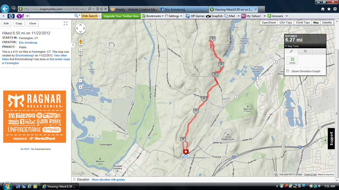
Section: Prattling Pond Road (Farmington, CT) to Kilkenny Rock Trail (West Hartford, CT)
Distance: 6.5 miles (out and back)
Approximate time to complete: 2.5 hours
Date Hiked: 11/22/2012
Date Published: 1/8/2013
The story behind my return to The Metacomet is an involved one, but I think it is important to share. My hope is that you will see how hard it is for me, on certain occasions, just to decide which trail to hike. For example, it would be easy with these longer trails to just pick up where I last left off. But, that doesn’t take into consideration the time I have to complete the hike, whether or not I’ll need two vehicles, or how “bored” I am with hiking the same trail every weekend. Yes, as much as I love these trails, they do get stale from time to time and I find it important to switch it up.
The decision-process for this hike started a few days before the hike, with me trying to find somewhere to hike on Thanksgiving morning. No easy feat when you consider that 1.) Jaci wasn’t going to be around to drop me off (she was going to NYC the night before to watch the balloons for the Macy’s Parade get filled), 2.) I hadn’t yet figured out how to make any of the remaining sections of The Shenipsit into a loop hike, and 3.) I had to be able to make it back to the house and drop off Roscoe in time to clean up so I could make it to my parent’s in time for Thanksgiving dinner. Around this time, I had been reading a lot about Squaw Cave so I thought maybe I would check that out. But, then I heard that the parking area near Bolton Notch State Park might be used for the Manchester Road Race Shuttle. Later, I found out this wasn’t true but by then I had already moved off of that idea. I also considered some hikes close to my parents but, ruled that out when I remembered I would have to bring Roscoe home first.
At some point, I started scouring the CFPA Walk Book for potential loop hikes. I’m not sure why because, in the past when I’ve done this, I’ve only ended up frustrated. Fortunately, this time, I happened to notice an alternate / side trai off of The Metacomet called the Kilkenny Rock Trail. Since I would have to re-hike a section of the Metacomet in order to do all of the main Metacomet miles AND hike Kilkenny Rock Trail (all required to complete the CT400), I decided to make this an out and back hike.
As a book end to this discussion of decision-making, it is important to note this is not the case for every hike. Often times, I decide on a place…pack up…and go.
The morning of the hike, I also decided to do a little scouting for future hikes. I knew a section of The Shenipsit Trail (which I’ve covered in other recent writings) crossed Rt. 2 in Glastonbury and I wanted to check out the parking situation on both sides before I considered how best to tackle that area. I was also up a little earlier than I expected so the sun wasn’t quite high enough for me to start hiking anyway. Trying to explain this to Roscoe was challenging as he cried and cried the whole ride out to the scout area and then cried and cried the whole ride to the spot where we were actually hiking. He really does love these hikes.
Once we got to the commuter lot off of Rt. 4 in Farmington (the same lot where Jaci and I left my car on Hike #1), I began putting my gear together and noticed I had made a huge mistake…I had left the house without Roscoe’s leash. Any other hike and this wouldn’t be a huge problem because we are usually deep in the forest, have the place pretty much to ourselves, and he runs off leash 95 % of the trip anyway. But, on this hike, we were immediately crossing a very busy intersection and my research had shown that there are a couple of busy road walks along the way. I was going to need his leash.
Fortunately, once my frustration subsided, I remembered a recent trip to my parents where Jaci and I (arriving separately) had each brought a leash. In the trunk of my car, sitting as if it had been waiting for this one moment to shine in the spotlight, was his alternate leash. I made that sound a lot more dramatic than it really was, but I swear we’ve used this thing maybe twice. We got it when he was still a puppy and, at four feet in length (instead of the standard six), it looks ridiculous. Picture in your head a six foot, three inch man who weighs around 320 pounds (at the time) walking an 80 pound dog on a short leash. Now you understand what I’m working with. But, this leash…this ridiculous looking leash, was all I needed to manage the sections of this hike where a leash was required. Now, it sits in the trunk…waiting for me to forget his actual leash again…like the faithful back-up that it is.
I understand that this business with the leash probably seems trivial to the average reader, but our dog is a spoiled rotten dog and, if I were to turn around and go home to get his leash after all of the driving around we just did, it would have been torture…for both of us. In summary, Roscoe really knows how to get his way (I wonder who taught him that). Anyway, so after all of this, we finally hit the trail.
If you remember from my Hike #1 recap, this section of The Metacomet crosses Rt. 4 and then skirts along the side of it for a while before coming to Prattling Pond Road. I was glad I covered those steps at the end of my previous hike with Jaci. This way, Roscoe and I could just to hit Prattling Pond Road and go.
The trail follows Prattling Pond Road for about ten seconds of road walk and then turns right, into a field. Immediately I began to wonder if the grass was long enough and the air warm enough to support ticks. And, I was also thankful to be taking this hike in November instead of May or June, when I’m sure the area is crawling with them. I checked him once we go the end of the field and didn’t see any evidence of the nasty critters.
On the other side of the field, the trail turns left and begins making its way back out to Prattling Pond Road. I made a mental note to just to follow the road on the way back to the car and avoid the field. It is a nice field, but with temperatures warming, I wanted to avoid ticks at all cost.
Once the trail reaches the road again, it turns right and becomes a road walk for maybe a half mile or so before ducking back into the “woods”. I say “woods” because you are really in people’s backyards. Usually, when I come to sections of trail like this, I try to avoid looking in people’s back windows by looking in the completely opposite direction. But, on this little section of trail, there are houses straddling both sides. So, head down, I made my way through…but not before noticing an odd smell coming from one of the backyards. I don’t know what a dead body smells like but it definitely smelled like something died. Roscoe didn’t seem to notice it (until we came back through the area) and I wasn’t in the mood to unearth any bodies. So, we trekked on.
The trail eventually comes out to another residential neighborhood and follows Metacomet Road for a while. For some reason, instead of just following the road all the way down to the intersection with Talcott Notch Road, it heads about 10 feet off from the road and heads through what looks like people’s front yards. It also does this on Prattling Pond Road for a bit. At first, I didn’t mind it. The second time, I found it strange and made a mental note just to stick to the road on the way back. There is a tree line here so it is a little more like hiking than a road walk would be…but, when you can still see the road, what’s the point?
Eventually, the trail crosses Talcott Notch Road and can be tricky. Your natural reaction is to follow the power line cut that is here but the trail actually runs right along the fence (which looks like an electric fence) and past the backyard of the homeowner. Here it swings casually through the woods for about a half of a mile before making a left on Old Mountain Road.
At this point of the hike, I was thankful for the extra leash because this is a semi-challenging road walk with not much of a shoulder. We were fortunate that we didn’t get passed by too many cars but we did see a few mountain bikers on the other side of the fence which separates the road and MDC (a local water company) land. And, I’m certain Roscoe would have tried to greet them all if I didn’t find that spare leash in the trunk.
The trail follows Old Mountain Road for a few minutes before making a right through the fence and onto MDC property. A few of the bikers had fallen behind and waited for us to go on up ahead while they rehydrated. After a short walk, the trail makes a right and crosses a power line cut. Once it lead us back into the woods, I was able to let Roscoe off leash for the first time and he ran around like a crazy dog.
The trail eventually links up with what looks like a dirt road and follows that uphill. Then, it crosses a slightly better road (which may have been paved). At this point, I began to notice a couple of big blue water tanks. I was so distracted by them that I thought I missed the turnoff for the Kilkenny Rock Trail. I wasn’t too concerned since I was actually waiting for the second Kilkenny turnoff anyway. But, then it occurred to me that if I wasn’t sure that I missed the first, how would I know when I got to the second? This forced me to do some exploring and doubling back before finally finding the right trail.
Once I found Kilkenny Rock Trail (yellow blazed), I made my way up to the viewpoint described in the CFPA Walk Book to see…nothing. There was a ton of fog covering the low-lying areas around the ridge. It took a while, but I think I was finally able to locate the UConn Health Building. Although, I needed my binoculars in order to see it so I’m still not sure. Since I was getting ready to head back to the car, I figured I would have to travel a portion of this trail again in order to get to the next section anyway. So, I reasoned that I will just have to try this viewpoint again on a clearer day. While we were up there, we also spotted the group of mountain bikers (at least, I think it was the same group) and watched them do their thing for a while. I don’t think they saw us but I also don’t think they cared about us…which is fine.
The section of the Kilkenny Rock Trail which heads back to The Metacomet descends quickly and I found it to be a little steep. Once I saw the familiar blue blazes, I turned to see how I could have missed the initial Kilkenny turn off and I couldn’t figure it out. The blazes are there. Maybe the sun was hitting the tree in a way that the blaze was hard to see. Maybe I’m just bad at this hiking thing. I dunno.
On our way back to the car, we followed mostly the same trail we took on the way out (except where I previously noted I would just stick to the road) and had a cool experience with a couple of Chocolate Labs in the area. On Prattling Pond Road, just before the intersection with Rt. 4 there is a large house with a large front yard (common in these parts) and a rock wall. As we were approaching, I heard several loud barks just before a 100 pound lab came charging down from the house to the foot of the wall. He was wearing an electric fence collar…so, at no point was I concerned for our safety…but the speed with which he pursued us caused Roscoe to get all excited. Like long-lost cousins, they’re aggression quickly turned to joy and the tails were a waggin’. A few seconds later, the first dog was joined by its slightly smaller (maybe 5 pounds or so) brother. I’m not exaggerating when I tell you there was a breeze in the air from all of the tail wagging that was going on! And, it brought a smile to my face that I was able to be a part of this apparent “family reunion”. Good times.
Trail: Metacomet
Section: Prattling Pond Road (Farmington, CT) to Kilkenny Rock Trail (West Hartford, CT)
Distance: 6.5 miles (out and back)
Approximate time to complete: 2.5 hours
Date Hiked: 11/22/2012
Date Published: 1/8/2013
The story behind my return to The Metacomet is an involved one, but I think it is important to share. My hope is that you will see how hard it is for me, on certain occasions, just to decide which trail to hike. For example, it would be easy with these longer trails to just pick up where I last left off. But, that doesn’t take into consideration the time I have to complete the hike, whether or not I’ll need two vehicles, or how “bored” I am with hiking the same trail every weekend. Yes, as much as I love these trails, they do get stale from time to time and I find it important to switch it up.
The decision-process for this hike started a few days before the hike, with me trying to find somewhere to hike on Thanksgiving morning. No easy feat when you consider that 1.) Jaci wasn’t going to be around to drop me off (she was going to NYC the night before to watch the balloons for the Macy’s Parade get filled), 2.) I hadn’t yet figured out how to make any of the remaining sections of The Shenipsit into a loop hike, and 3.) I had to be able to make it back to the house and drop off Roscoe in time to clean up so I could make it to my parent’s in time for Thanksgiving dinner. Around this time, I had been reading a lot about Squaw Cave so I thought maybe I would check that out. But, then I heard that the parking area near Bolton Notch State Park might be used for the Manchester Road Race Shuttle. Later, I found out this wasn’t true but by then I had already moved off of that idea. I also considered some hikes close to my parents but, ruled that out when I remembered I would have to bring Roscoe home first.
At some point, I started scouring the CFPA Walk Book for potential loop hikes. I’m not sure why because, in the past when I’ve done this, I’ve only ended up frustrated. Fortunately, this time, I happened to notice an alternate / side trai off of The Metacomet called the Kilkenny Rock Trail. Since I would have to re-hike a section of the Metacomet in order to do all of the main Metacomet miles AND hike Kilkenny Rock Trail (all required to complete the CT400), I decided to make this an out and back hike.
As a book end to this discussion of decision-making, it is important to note this is not the case for every hike. Often times, I decide on a place…pack up…and go.
The morning of the hike, I also decided to do a little scouting for future hikes. I knew a section of The Shenipsit Trail (which I’ve covered in other recent writings) crossed Rt. 2 in Glastonbury and I wanted to check out the parking situation on both sides before I considered how best to tackle that area. I was also up a little earlier than I expected so the sun wasn’t quite high enough for me to start hiking anyway. Trying to explain this to Roscoe was challenging as he cried and cried the whole ride out to the scout area and then cried and cried the whole ride to the spot where we were actually hiking. He really does love these hikes.
Once we got to the commuter lot off of Rt. 4 in Farmington (the same lot where Jaci and I left my car on Hike #1), I began putting my gear together and noticed I had made a huge mistake…I had left the house without Roscoe’s leash. Any other hike and this wouldn’t be a huge problem because we are usually deep in the forest, have the place pretty much to ourselves, and he runs off leash 95 % of the trip anyway. But, on this hike, we were immediately crossing a very busy intersection and my research had shown that there are a couple of busy road walks along the way. I was going to need his leash.
Fortunately, once my frustration subsided, I remembered a recent trip to my parents where Jaci and I (arriving separately) had each brought a leash. In the trunk of my car, sitting as if it had been waiting for this one moment to shine in the spotlight, was his alternate leash. I made that sound a lot more dramatic than it really was, but I swear we’ve used this thing maybe twice. We got it when he was still a puppy and, at four feet in length (instead of the standard six), it looks ridiculous. Picture in your head a six foot, three inch man who weighs around 320 pounds (at the time) walking an 80 pound dog on a short leash. Now you understand what I’m working with. But, this leash…this ridiculous looking leash, was all I needed to manage the sections of this hike where a leash was required. Now, it sits in the trunk…waiting for me to forget his actual leash again…like the faithful back-up that it is.
I understand that this business with the leash probably seems trivial to the average reader, but our dog is a spoiled rotten dog and, if I were to turn around and go home to get his leash after all of the driving around we just did, it would have been torture…for both of us. In summary, Roscoe really knows how to get his way (I wonder who taught him that). Anyway, so after all of this, we finally hit the trail.
If you remember from my Hike #1 recap, this section of The Metacomet crosses Rt. 4 and then skirts along the side of it for a while before coming to Prattling Pond Road. I was glad I covered those steps at the end of my previous hike with Jaci. This way, Roscoe and I could just to hit Prattling Pond Road and go.
The trail follows Prattling Pond Road for about ten seconds of road walk and then turns right, into a field. Immediately I began to wonder if the grass was long enough and the air warm enough to support ticks. And, I was also thankful to be taking this hike in November instead of May or June, when I’m sure the area is crawling with them. I checked him once we go the end of the field and didn’t see any evidence of the nasty critters.
On the other side of the field, the trail turns left and begins making its way back out to Prattling Pond Road. I made a mental note to just to follow the road on the way back to the car and avoid the field. It is a nice field, but with temperatures warming, I wanted to avoid ticks at all cost.
Once the trail reaches the road again, it turns right and becomes a road walk for maybe a half mile or so before ducking back into the “woods”. I say “woods” because you are really in people’s backyards. Usually, when I come to sections of trail like this, I try to avoid looking in people’s back windows by looking in the completely opposite direction. But, on this little section of trail, there are houses straddling both sides. So, head down, I made my way through…but not before noticing an odd smell coming from one of the backyards. I don’t know what a dead body smells like but it definitely smelled like something died. Roscoe didn’t seem to notice it (until we came back through the area) and I wasn’t in the mood to unearth any bodies. So, we trekked on.
The trail eventually comes out to another residential neighborhood and follows Metacomet Road for a while. For some reason, instead of just following the road all the way down to the intersection with Talcott Notch Road, it heads about 10 feet off from the road and heads through what looks like people’s front yards. It also does this on Prattling Pond Road for a bit. At first, I didn’t mind it. The second time, I found it strange and made a mental note just to stick to the road on the way back. There is a tree line here so it is a little more like hiking than a road walk would be…but, when you can still see the road, what’s the point?
Eventually, the trail crosses Talcott Notch Road and can be tricky. Your natural reaction is to follow the power line cut that is here but the trail actually runs right along the fence (which looks like an electric fence) and past the backyard of the homeowner. Here it swings casually through the woods for about a half of a mile before making a left on Old Mountain Road.
At this point of the hike, I was thankful for the extra leash because this is a semi-challenging road walk with not much of a shoulder. We were fortunate that we didn’t get passed by too many cars but we did see a few mountain bikers on the other side of the fence which separates the road and MDC (a local water company) land. And, I’m certain Roscoe would have tried to greet them all if I didn’t find that spare leash in the trunk.
The trail follows Old Mountain Road for a few minutes before making a right through the fence and onto MDC property. A few of the bikers had fallen behind and waited for us to go on up ahead while they rehydrated. After a short walk, the trail makes a right and crosses a power line cut. Once it lead us back into the woods, I was able to let Roscoe off leash for the first time and he ran around like a crazy dog.
The trail eventually links up with what looks like a dirt road and follows that uphill. Then, it crosses a slightly better road (which may have been paved). At this point, I began to notice a couple of big blue water tanks. I was so distracted by them that I thought I missed the turnoff for the Kilkenny Rock Trail. I wasn’t too concerned since I was actually waiting for the second Kilkenny turnoff anyway. But, then it occurred to me that if I wasn’t sure that I missed the first, how would I know when I got to the second? This forced me to do some exploring and doubling back before finally finding the right trail.
Once I found Kilkenny Rock Trail (yellow blazed), I made my way up to the viewpoint described in the CFPA Walk Book to see…nothing. There was a ton of fog covering the low-lying areas around the ridge. It took a while, but I think I was finally able to locate the UConn Health Building. Although, I needed my binoculars in order to see it so I’m still not sure. Since I was getting ready to head back to the car, I figured I would have to travel a portion of this trail again in order to get to the next section anyway. So, I reasoned that I will just have to try this viewpoint again on a clearer day. While we were up there, we also spotted the group of mountain bikers (at least, I think it was the same group) and watched them do their thing for a while. I don’t think they saw us but I also don’t think they cared about us…which is fine.
The section of the Kilkenny Rock Trail which heads back to The Metacomet descends quickly and I found it to be a little steep. Once I saw the familiar blue blazes, I turned to see how I could have missed the initial Kilkenny turn off and I couldn’t figure it out. The blazes are there. Maybe the sun was hitting the tree in a way that the blaze was hard to see. Maybe I’m just bad at this hiking thing. I dunno.
On our way back to the car, we followed mostly the same trail we took on the way out (except where I previously noted I would just stick to the road) and had a cool experience with a couple of Chocolate Labs in the area. On Prattling Pond Road, just before the intersection with Rt. 4 there is a large house with a large front yard (common in these parts) and a rock wall. As we were approaching, I heard several loud barks just before a 100 pound lab came charging down from the house to the foot of the wall. He was wearing an electric fence collar…so, at no point was I concerned for our safety…but the speed with which he pursued us caused Roscoe to get all excited. Like long-lost cousins, they’re aggression quickly turned to joy and the tails were a waggin’. A few seconds later, the first dog was joined by its slightly smaller (maybe 5 pounds or so) brother. I’m not exaggerating when I tell you there was a breeze in the air from all of the tail wagging that was going on! And, it brought a smile to my face that I was able to be a part of this apparent “family reunion”. Good times.