Hikes #21 & 22
Trail: Shenipsit
Sections: Camp Meeting Road (Bolton, CT) to Amanda Drive (Manchester, CT) & Parker Road (Ellington, CT) to Gulf Road (Somers, CT)
Date Hiked: 12/15/2012
Date Published: 1/14/2013
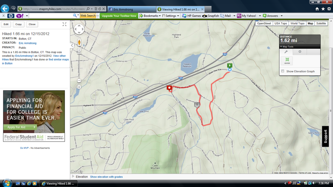
The morning of hikes # 21 and 22, I woke up originally planning only to complete the section of Shenipsit between Camp Meeting Road and Amanda Drive. I previously skipped portions of the trail after frustrations mounted on my hike from Hebron Avenue to Bolton Notch. So, now, I had to go back and get the sections I missed.
Earlier in the week, Jaci and I worked out a plan. We would leave my car at the Birch Mountain Road parking lot (near the Case Mountain Trails) and she would drop me off at the Camp Meeting Road trail head on her way out to my parents (she and my mom were planning to continue their “slowly-becoming-world-famous” Christmas cookie baking).
The make-up hike I’m calling Hike #21 was really brief and I have a hard time even calling it a hike. I was already in a bit of a bad mood because I thought it was ridiculous that I had to make these sections up. I understand the importance of actually doing the CT400 in order to say I did the CT400…but, I wasn’t exactly thrilled about hiking portions of this section “again”. Anyway, I’m a good solider so I did what I had to in order to get it done.
This second time through wasn’t as difficult, but it also wasn’t without its challenges. They started almost immediately when I came to a section between Camp Meeting Road and Carter Road which required me to cross a brook. Most of these brook crossings are pretty easy. A lot of times you have to cross on rocks and occasionally you get a portion or all of your foot / feet wet. This brook, however, cut through the soil in such a way that there was a drop followed by a little bit of water and then an ascent on the other side. This probably still doesn’t sound very challenging but the issue was I couldn’t see a way to get across this little“ravine” without risking a slip and a fall into the brook. There was a fallen tree which crossed the brook in a way that it could almost serve as a bridge, but it wasn’t very wide and I had recently had some issues with my balance. So, after some debate, I decided to give the tree / balance beam scenario a shot. And, I made it without falling. I know I made this into a much bigger deal than it really was, but these are the kinds of things that sometimes stack up to make hiking not so fun.
From the brook crossing, I made my way out to the gas pipeline section where I had lost the trail last time, When I turned around to see how I could’ve missed the turn off last time, I had to chuckle. I don’t know how I miss this stuff. The turn off is clearly marked.
I made my way out to Carter Street and crossed it. This short section is really weird. The trail, which follows the pipeline on the other side of Carter Street, ducks into the woods here. But, it is only about ten feet from the pipeline cut and, eventually, makes its way back out to the cut…only to duck back into the woods again. Someone needs to make up their mind if they want it to follow the cut or not.
From the last turn off, the trail heads downhill and looks like it is heading right for someone’s backyard. It avoids the backyard…but just barely…and eventually leads out to Amanda Drive. I was glad to know that the trail went exactly where I thought it did the last time I was in the area. I made way through the pricker bushes and…finally…completed this section.
Of course, I had another decision to make. Should I battle my way through more backyards and take the short cut route out to Birch Mountain Road? Or, should I walk the roads (Amanda, Carter, and Camp Meeting) back to the Birch Mountain Road lot where my car was waiting?
After a few seconds, I decided I didn’t want to fight with the pricker bushes, mud, and poor blazing so I just walked the roads.
On the way back to my car, I decided this hike was far too short and it was far too nice of a day to call it quits. So, when I got home, I quickly put together a loop hike which would bring me to the summit of Soapstone Mountain in Somers. Originally, I was going to wait and make Soapstone the last section of my Shenipsit adventures. But, I had grown impatient and decided I couldn’t wait any longer to make that trek.
Earlier that day, since I wasn’t sure what to expect in Bolton / Manchester, I had left Roscoe at home. This time, I still didn’t know what to expect, but I knew I couldn’t leave him at home again. So, he hopped in the car with me and we hit the road.
I parked at the base of Soapstone Mountain, off of Gulf Road in Somers. If you wanted, you can drive to the top of the mountain. But, why would you want to do that?
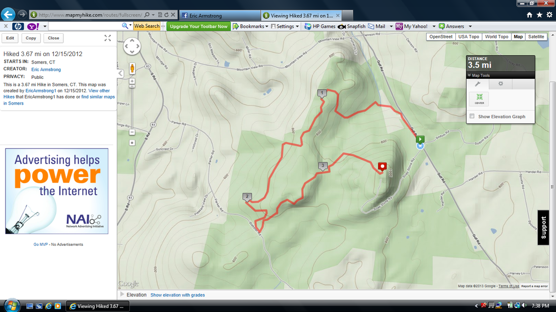
In a weird way, I felt that just hiking to the top of the mountain from the lot off of Gulf Road would cheapen the experience. I wanted to earn it. So, I designed a hike that would follow Gulf Road for a bit to the north before taking the Yellow / Orange Trail to the west. This would allow me to meet up with The Shenipsit south of the mountain and make my way back to the summit after a few miles of hiking.
The map I printed from the Shenipsit State Forest website was a bit misleading in that it implies the trail I was taking out is yellow and orange blazed. I did see occasional orange blazes (like maybe one or two) but it was mostly just yellow blazes…and even those are few and far between. The trail follows what appears to be an ATV trail…so it isn’t hard to follow. I just found it odd that there weren’t many blazes.
There were many times when I questioned if I was on the right trail. Thankfully, I had my MapMyHike app. So, I just kept checking that
and confirming that I was following a path which looked similar to the path of the trail outlined on the map I printed. In spite of the incorrect / lack of blazing, I really enjoyed this trail. There are several views to the south which include Soapstone Mountain. This allowed for my excitement to build as I knew that it wouldn’t be long before I would be on top of that bad boy.
The Yellow / Orange (mostly just Yellow) Trail follows a path that takes the hiker out to the northwest corner of the state forest. At one point, it even brought us right to the edge of the state forest boundary before turning and heading southeast.
Eventually, we came to Parker Road and turned left. The blue-blazed Shenipsit Trail was only a few hundred feet to the southeast and, when we found it, we made another left turn.
From Parker Road, we followed the blue blazes for about a mile until we came to the base of the mountain. I won’t lie…this is a pretty steep climb. I took a minute to read an informational plaque in the area and then decided I had stalled long enough. The climb to the top was pretty brutal. Roscoe didn’t seem to have any trouble (leaving me in his dust) but I struggled. At this point, I was still getting in shape and this was the toughest climb I had done in a while. I could only imagine how badly I would have struggled a year earlier. I do not recommend this climb for anyone who is just starting out. If you have limited hiking experience but want to get to the top of Soapstone Mountain, I suggest you park off of Gulf Road and walk by following the road up to the top. That way is a much more gradual climb. Or, I guess…if you really had to…you
could always drive up. I wouldn’t do it that way but you are more than welcome to.
Once I reached the top, I tied Roscoe to one of the support beams of the lookout tower and climbed the stairs to the top. I don’t know what I was expecting with regards to the tower…but it looked a lot less strong than I anticipated. A few of the stairs (which are metal) had a lot of give to them. Of course, not everyone that goes up there is 300+ pounds. But, regardless, the steps and the platform at the top aren’t as sturdy as I expected. However, the views up here leave nothing else to be desired. They are…flat out amazing. I’m not exactly sure what I was looking at (since there isn’t a diagram) but the tower provides an almost fully panoramic view of the surrounding areas. It was awesome!
Since I had used my MapMyHike app all morning, and kept having to check it on the first left of this hike, the battery on my phone was starting to die. So, I saved the progress I made and turned off the app. The second map below will make it look like I never made it back to my car…but I did.
The descent on the other side of the mountain is just as steep as the way up. I took my time…stopping to read some of the other informational plaques and eventually we made our way back to flat ground. A quarter of a mile later, we were back at the car.
All in all, this was a good day of hiking. I was happy that I was able to turn what was supposed to only be a make-up hike into a day in which I hiked to the highest elevation I had ever been to. I know 1075 feet isn’t much…but it beats the heck out of that 700 foot stuff I had been doing up until now. I look forward to the days when I start knocking out 2000 foot elevations and laugh at how happy I was only to do 1000 feet. But for now, I’ll look at my little 1000 foot elevation with a sense of pride.
Trail: Shenipsit
Sections: Camp Meeting Road (Bolton, CT) to Amanda Drive (Manchester, CT) & Parker Road (Ellington, CT) to Gulf Road (Somers, CT)
Date Hiked: 12/15/2012
Date Published: 1/14/2013
The morning of hikes # 21 and 22, I woke up originally planning only to complete the section of Shenipsit between Camp Meeting Road and Amanda Drive. I previously skipped portions of the trail after frustrations mounted on my hike from Hebron Avenue to Bolton Notch. So, now, I had to go back and get the sections I missed.
Earlier in the week, Jaci and I worked out a plan. We would leave my car at the Birch Mountain Road parking lot (near the Case Mountain Trails) and she would drop me off at the Camp Meeting Road trail head on her way out to my parents (she and my mom were planning to continue their “slowly-becoming-world-famous” Christmas cookie baking).
The make-up hike I’m calling Hike #21 was really brief and I have a hard time even calling it a hike. I was already in a bit of a bad mood because I thought it was ridiculous that I had to make these sections up. I understand the importance of actually doing the CT400 in order to say I did the CT400…but, I wasn’t exactly thrilled about hiking portions of this section “again”. Anyway, I’m a good solider so I did what I had to in order to get it done.
This second time through wasn’t as difficult, but it also wasn’t without its challenges. They started almost immediately when I came to a section between Camp Meeting Road and Carter Road which required me to cross a brook. Most of these brook crossings are pretty easy. A lot of times you have to cross on rocks and occasionally you get a portion or all of your foot / feet wet. This brook, however, cut through the soil in such a way that there was a drop followed by a little bit of water and then an ascent on the other side. This probably still doesn’t sound very challenging but the issue was I couldn’t see a way to get across this little“ravine” without risking a slip and a fall into the brook. There was a fallen tree which crossed the brook in a way that it could almost serve as a bridge, but it wasn’t very wide and I had recently had some issues with my balance. So, after some debate, I decided to give the tree / balance beam scenario a shot. And, I made it without falling. I know I made this into a much bigger deal than it really was, but these are the kinds of things that sometimes stack up to make hiking not so fun.
From the brook crossing, I made my way out to the gas pipeline section where I had lost the trail last time, When I turned around to see how I could’ve missed the turn off last time, I had to chuckle. I don’t know how I miss this stuff. The turn off is clearly marked.
I made my way out to Carter Street and crossed it. This short section is really weird. The trail, which follows the pipeline on the other side of Carter Street, ducks into the woods here. But, it is only about ten feet from the pipeline cut and, eventually, makes its way back out to the cut…only to duck back into the woods again. Someone needs to make up their mind if they want it to follow the cut or not.
From the last turn off, the trail heads downhill and looks like it is heading right for someone’s backyard. It avoids the backyard…but just barely…and eventually leads out to Amanda Drive. I was glad to know that the trail went exactly where I thought it did the last time I was in the area. I made way through the pricker bushes and…finally…completed this section.
Of course, I had another decision to make. Should I battle my way through more backyards and take the short cut route out to Birch Mountain Road? Or, should I walk the roads (Amanda, Carter, and Camp Meeting) back to the Birch Mountain Road lot where my car was waiting?
After a few seconds, I decided I didn’t want to fight with the pricker bushes, mud, and poor blazing so I just walked the roads.
On the way back to my car, I decided this hike was far too short and it was far too nice of a day to call it quits. So, when I got home, I quickly put together a loop hike which would bring me to the summit of Soapstone Mountain in Somers. Originally, I was going to wait and make Soapstone the last section of my Shenipsit adventures. But, I had grown impatient and decided I couldn’t wait any longer to make that trek.
Earlier that day, since I wasn’t sure what to expect in Bolton / Manchester, I had left Roscoe at home. This time, I still didn’t know what to expect, but I knew I couldn’t leave him at home again. So, he hopped in the car with me and we hit the road.
I parked at the base of Soapstone Mountain, off of Gulf Road in Somers. If you wanted, you can drive to the top of the mountain. But, why would you want to do that?
In a weird way, I felt that just hiking to the top of the mountain from the lot off of Gulf Road would cheapen the experience. I wanted to earn it. So, I designed a hike that would follow Gulf Road for a bit to the north before taking the Yellow / Orange Trail to the west. This would allow me to meet up with The Shenipsit south of the mountain and make my way back to the summit after a few miles of hiking.
The map I printed from the Shenipsit State Forest website was a bit misleading in that it implies the trail I was taking out is yellow and orange blazed. I did see occasional orange blazes (like maybe one or two) but it was mostly just yellow blazes…and even those are few and far between. The trail follows what appears to be an ATV trail…so it isn’t hard to follow. I just found it odd that there weren’t many blazes.
There were many times when I questioned if I was on the right trail. Thankfully, I had my MapMyHike app. So, I just kept checking that
and confirming that I was following a path which looked similar to the path of the trail outlined on the map I printed. In spite of the incorrect / lack of blazing, I really enjoyed this trail. There are several views to the south which include Soapstone Mountain. This allowed for my excitement to build as I knew that it wouldn’t be long before I would be on top of that bad boy.
The Yellow / Orange (mostly just Yellow) Trail follows a path that takes the hiker out to the northwest corner of the state forest. At one point, it even brought us right to the edge of the state forest boundary before turning and heading southeast.
Eventually, we came to Parker Road and turned left. The blue-blazed Shenipsit Trail was only a few hundred feet to the southeast and, when we found it, we made another left turn.
From Parker Road, we followed the blue blazes for about a mile until we came to the base of the mountain. I won’t lie…this is a pretty steep climb. I took a minute to read an informational plaque in the area and then decided I had stalled long enough. The climb to the top was pretty brutal. Roscoe didn’t seem to have any trouble (leaving me in his dust) but I struggled. At this point, I was still getting in shape and this was the toughest climb I had done in a while. I could only imagine how badly I would have struggled a year earlier. I do not recommend this climb for anyone who is just starting out. If you have limited hiking experience but want to get to the top of Soapstone Mountain, I suggest you park off of Gulf Road and walk by following the road up to the top. That way is a much more gradual climb. Or, I guess…if you really had to…you
could always drive up. I wouldn’t do it that way but you are more than welcome to.
Once I reached the top, I tied Roscoe to one of the support beams of the lookout tower and climbed the stairs to the top. I don’t know what I was expecting with regards to the tower…but it looked a lot less strong than I anticipated. A few of the stairs (which are metal) had a lot of give to them. Of course, not everyone that goes up there is 300+ pounds. But, regardless, the steps and the platform at the top aren’t as sturdy as I expected. However, the views up here leave nothing else to be desired. They are…flat out amazing. I’m not exactly sure what I was looking at (since there isn’t a diagram) but the tower provides an almost fully panoramic view of the surrounding areas. It was awesome!
Since I had used my MapMyHike app all morning, and kept having to check it on the first left of this hike, the battery on my phone was starting to die. So, I saved the progress I made and turned off the app. The second map below will make it look like I never made it back to my car…but I did.
The descent on the other side of the mountain is just as steep as the way up. I took my time…stopping to read some of the other informational plaques and eventually we made our way back to flat ground. A quarter of a mile later, we were back at the car.
All in all, this was a good day of hiking. I was happy that I was able to turn what was supposed to only be a make-up hike into a day in which I hiked to the highest elevation I had ever been to. I know 1075 feet isn’t much…but it beats the heck out of that 700 foot stuff I had been doing up until now. I look forward to the days when I start knocking out 2000 foot elevations and laugh at how happy I was only to do 1000 feet. But for now, I’ll look at my little 1000 foot elevation with a sense of pride.
Hike #21 Map
Hike #22 Map