Hike #23
Trail: Shenipsit
Section: Gadpouch Road (East Hampton, CT) to Rt. 2 (Glastonbury, CT)
Direction of Travel: South to North
Distance: 8.2 miles
Approx. time to complete: 3.5 hours
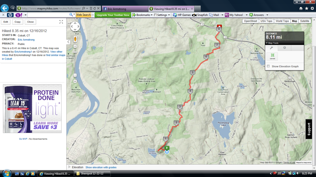
Date Hiked: 12/16/2012
Date Published: 1/15/2013
Trail: Shenipsit
Section: Gadpouch Road (East Hampton, CT) to Rt. 2 (Glastonbury, CT)
Direction of Travel: South to North
Distance: 8.2 miles
Approx. time to complete: 3.5 hours
Date Hiked: 12/16/2012
Date Published: 1/15/2013

I was very excited for this hike. At this point, I’ve covered most of the Shenipsit and I felt I was finally ready to tackle the southernmost section. While doing my research, I thought this section sounded pretty challenging, especially the first mile or so. So, I had put it off until now. But, my anticipation had built (over about six weeks or so) to a boiling point and I couldn’t put it off any longer. And, as I would find out,
it wasn't nearly as challenging as I thought it would be. Of course, that could be because by the time I finally made this hike, I had gotten myself into pretty good hiking shape.
I’m not sure why, but I always start these long trails in the middle sections (I did it with the Metacomet and the Mattabesett too). I’ll have to keep that in mind when I start the long trails going forward and make sure I start them at the beginning. That way, I can experience the trail from beginning to end in the way it was intended.
Jaci was again heading out to my parents so her and my mom could continue their Christmas cookie baking. So, we dropped my car at the parking area off of Rt. 2…the same parking area where I left my car on my Hike # 19. Later, this would create some problems but we’ll cover that when we get there. For now, I hopped in the Jeep and we made our way to the south trail head, which is located near the intersections of Rt. 66 and Rt. 151 in Cobalt.
The trail begins just off of a dirt road (Gadpouch Road) in East Hampton. The picture of me and Roscoe above was taken by Jaci (on her cell phone) just as we were hitting the trail. I like how you can see just how eager Roscoe is when we go hiking. To be honest, I’m surprised he even turned around for the picture.
The first half mile or so of this section can be pretty challenging. Almost immediately, it starts climbing to the top of Great Hill (at an elevation of 770 feet). There is a little area about half way up where the ridge kind of plateaus for a bit, which is nice because it allows you some time to catch your breath before climbing again.
At the top of Great Hill, the Shenipsit makes a right turn. But, there is a side trail to the left which leads to an awesome view overlooking Portland, Middletown, and the Connecticut River. I was glad I took the five additional minutes (if that) to hike this side trail and enjoy the view. It really got the adrenaline flowing, which was needed because a good portion of this hike is nothing but old woods roads. But, I’m getting ahead of myself.
Over the next two and a half miles or so, the trail follows the ridge and eventually summits Bald Hill (at an elevation of 893 feet). Somewhere in this stretch is supposedly an old quarry but I don’t recall seeing it. Regardless, I really enjoyed these miles. This area of the state is called the Meshomasic State Forest and it is, supposedly, the oldest state forest in CT (second oldest in the country)…which is pretty cool.
Somewhere in the next several miles, I passed what looked like an animal den up on a mini-cliff. There was, what looked like a trail leading up to the den. I was curious, but not curious enough to disturb some wild animal in the middle of the woods. I was hopeful I would see something in the surrounding area but never did. I also crossed a brook which, a little further down the trail, turned “waterfall-like”. These things are
never overly impressive but this one was covered with moss which gave the “falls” a cool green looking effect.
As I mentioned earlier, the remaining miles of this hike (of which there are a lot) are basically all woods roads. I don’t typically mind woods road here and there, but this was a bit much. The only time the trail left the woods road over the next three miles was to skirt around the areas of the trail that had become pure mud bog because of ATV activity. On the bright side, the sections that weren’t bog-ish allowed me to pick up the pace to where I was actually jogging some parts.
As we approached the end of the woods road madness, a dirt bike rider passed us going in the opposite direction. I only mention it because it was a hiking first.
It was also around this time that I started hearing gunshots. It was a Sunday and hiking is illegal on Sundays in CT so I was really hoping not to have to report any game violations. Fortunately, as I got closer to Rt. 2, I realized there were a lot more gunshots than what I thought necessary for hunting and they seemed to be timed at specific intervals. I remembered the shooting range from my Hike # 19 and figured it must not be abandoned after all. As we continued to get closer, I confirmed this to be the case.
The last two miles or so of this hike are a lot better than the middle miles. Eventually, the trail gets back to being just single-wide trail and, even though there is one more stretch of woods road, it is a lot more enjoyable.
What wasn’t enjoyable is the fact that the trail eventually runs right into Rt. 2…a fairly busy four lane highway (two lanes on each side) which connects the southeastern portion of the state (like our famous casinos) with Downtown Hartford and central Connecticut. The CFPA walk book recommends following several connector trails and roads to get around the highway. There are also several signs in the area urging hikers not to cross the highway on foot. I’ve read several blogs that admit to crossing the highway (there is a median wide enough to break it up into two runs) but I can’t personally recommend anyone do this. I thought about maybe starting this hike early in the morning and leaving Roscoe at home but I still don’t’ think I would feel comfortable enough to risk my life. I like hiking…but I don’t like it THAT much. So, when we got to this
point, I turned around and started heading back to one of the connector trails (the one that leads to Dickinson Road). There was a steep-ish hill to climb back up and a fallen tree to climb back over, but it was worth it knowing that we were safe.
At this point, I also noticed how badly I miscalculated the time it would take me to complete this section. So, I called Jaci and asked her to come pick me up. And, to top it all off, my phone battery was dying (this is like the third hike in a row). So, I stopped the MapMyHike app once I got to the Rt. 2 crossing. The map below won’t reflect the extra mile or two I walked while waiting for Jaci to make her way to us.
The miles of connector trail and road walk to go around Rt. 2 don’t count towards the CT400 so it wasn’t exactly cheating to have Jaci come get me. And, by the time she got to us, we covered half of the distance. If the CFPA ever decides to add the reaming miles to the CT400, I’ll go back for them. For now, I’m considering this section complete…which means I only had two more sections to cover and the Shenipsit would be complete. I’ll re-cap those hikes in future posts.