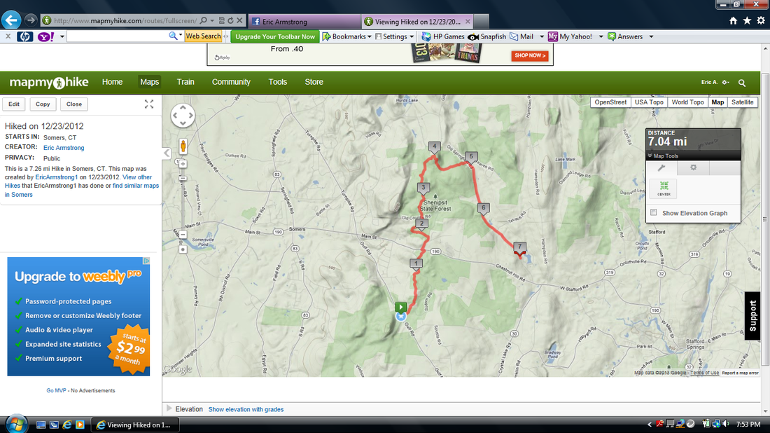
Hike #25
Trail: Shenipsit
Section: Gulf Road (Somers, CT) to Old Springfield Road (Stafford, CT)
Direction of Travel: South to North
Distance: Approx. 5 miles
Approx. time to complete: Unknown
Date Hiked: 12/23/2012
Date Published: 1/17/2013
Trail: Shenipsit
Section: Gulf Road (Somers, CT) to Old Springfield Road (Stafford, CT)
Direction of Travel: South to North
Distance: Approx. 5 miles
Approx. time to complete: Unknown
Date Hiked: 12/23/2012
Date Published: 1/17/2013
The fact that Hike #25 was also the hike in which I completed the last section of the Shenipsit Trail (and thus, completed the whole Shenipsit Trail) is purely coincidence. My only intention with this final hike of The Shenipsit was to complete it before Christmas…as a kind of Christmas present to myself.
This hike was another hike where, during my research, I had heard rumors of additional blazes which were recently added to the existing trail.
Sadly, Steve over at Connecticut Museum Quest had yet to verify the validity of these rumors. So, the only way for me to confirm the existence of trail additions was to head out and see for myself. I’m sure Jaci was more than nervous when I told her I thought the hike would only be “a couple of miles” but I wasn’t entirely sure because “there might be additional miles”. Either way, she allowed me to pack up my gear, load Roscoe into the car, and head out on this Sunday morning.
I parked my car in the lot off of Gulf Road (at the base of Soapstone Mountain)…the same lot I used on my Hike #22. The original plan was to follow the Shenipsit to the east and north then turn around (re-tracing my steps) once I reached the end of the trail. I would eventually alter this plan, adding miles of dangerous road walking to my total distance. It seems I didn’t learn my lesson about these road walks after my Hike #20 (through the Natchaug State Forest).
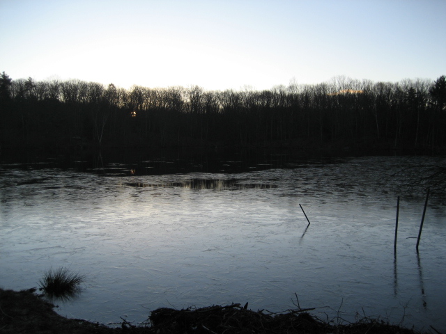
From the lot off of Gulf Road, the trail immediately crosses Gulf Road and heads east. Here, the trail follows Sodom Road and descends a bit to a pond.
This hike was another hike where, during my research, I had heard rumors of additional blazes which were recently added to the existing trail.
Sadly, Steve over at Connecticut Museum Quest had yet to verify the validity of these rumors. So, the only way for me to confirm the existence of trail additions was to head out and see for myself. I’m sure Jaci was more than nervous when I told her I thought the hike would only be “a couple of miles” but I wasn’t entirely sure because “there might be additional miles”. Either way, she allowed me to pack up my gear, load Roscoe into the car, and head out on this Sunday morning.
I parked my car in the lot off of Gulf Road (at the base of Soapstone Mountain)…the same lot I used on my Hike #22. The original plan was to follow the Shenipsit to the east and north then turn around (re-tracing my steps) once I reached the end of the trail. I would eventually alter this plan, adding miles of dangerous road walking to my total distance. It seems I didn’t learn my lesson about these road walks after my Hike #20 (through the Natchaug State Forest).
From the lot off of Gulf Road, the trail immediately crosses Gulf Road and heads east. Here, the trail follows Sodom Road and descends a bit to a pond.
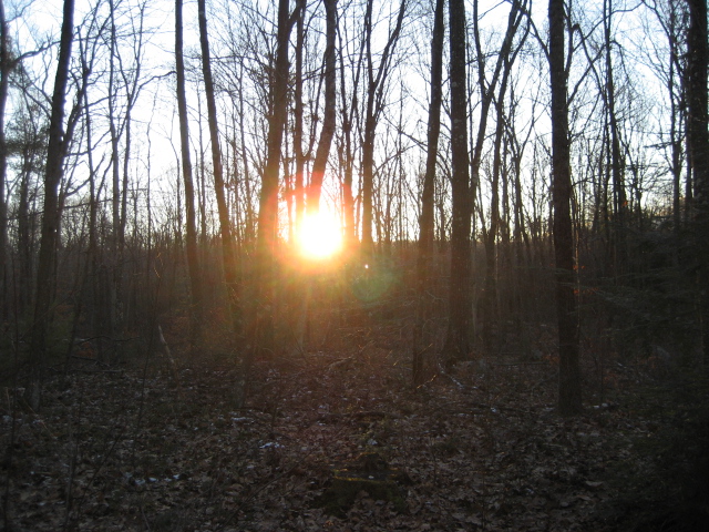
After a short walk, the trail turns away from Sodom Road and enters the woods to the north. It also starts to climb. Over the next half of a mile, the trail continues to climb and can be a bit steep in some areas. As I was hiking along, I was also keeping an eye behind me…waiting for a view of Soapstone Mountain through the trees. Eventually, I saw it and it was awesome. I had been up to the summit of the mountain a few weeks earlier and it was cool to see it now, from a different perspective. Keep in mind I was making this hike in December. So, the view may not be a year-round view.
Eventually, around the one mile mark, the trail leads back out to Sodom Road (the road curves, not the trail) and follows that for about a half of a mile. Then, it crosses over Rt. 190 (Chestnut Hill Road). This crossing can be dangerous so I leashed up Roscoe and we waited for an opportunity to cross.
The trail follows Rt. 190 for a minute or two before it turns right on to Galbraith Road. Here, the trail becomes a road walk for about a quarter of a mile before making a left turn on to Avery Road (which, if I recall correctly, is a dirt road). The trail only follows Avery for a minute or two before making a left turn into the woods.
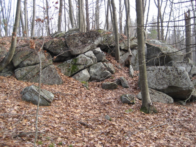
Here, around the two mile mark, the trail descends quickly to a brook crossing…only to climb again almost immediately after the brook. After another half of a mile or so, the trail reaches Old Country Road (a woods road). This used to be the end of the line, but I could see where the old completion blazes had been blacked out and where the trail continued on to the other side of Old Country Road. I was entering (somewhat) uncharted territory.
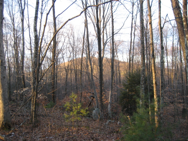
I really only expected the new section of the trail to go on for about a mile or so, but it goes on for almost two and half more miles. And, these are not questionable road walking miles like I experienced on my last hike. These are quality miles including a climb (around the four mile mark) up to a peak that, from all of the research I’ve done, appears to be unnamed. It is one of the higher peaks in the area (at just about 1000 feet it even rivals Soapstone Mountain). So, until someone tells me otherwise, this peak will be referred to as Eric Armstrong Hill. :)
The trail follows Rt. 190 for a minute or two before it turns right on to Galbraith Road. Here, the trail becomes a road walk for about a quarter of a mile before making a left turn on to Avery Road (which, if I recall correctly, is a dirt road). The trail only follows Avery for a minute or two before making a left turn into the woods.
Here, around the two mile mark, the trail descends quickly to a brook crossing…only to climb again almost immediately after the brook. After another half of a mile or so, the trail reaches Old Country Road (a woods road). This used to be the end of the line, but I could see where the old completion blazes had been blacked out and where the trail continued on to the other side of Old Country Road. I was entering (somewhat) uncharted territory.
I really only expected the new section of the trail to go on for about a mile or so, but it goes on for almost two and half more miles. And, these are not questionable road walking miles like I experienced on my last hike. These are quality miles including a climb (around the four mile mark) up to a peak that, from all of the research I’ve done, appears to be unnamed. It is one of the higher peaks in the area (at just about 1000 feet it even rivals Soapstone Mountain). So, until someone tells me otherwise, this peak will be referred to as Eric Armstrong Hill. :)
While I was enjoying some of the views on top of Eric Armstrong Hill :), I heard a bird call that was all too familiar to me. It sounded exactly like the large bird I had heard on top of John Tom Hill (by the communication towers) during my Hike #15. This time, when I got home, I remembered to look up this bird.
After hearing the bird the first time, I remembered thinking it was initially a Turkey Vulture. So, I started by looking up Turkey Vulture sounds…and, as it turns out, that bird lacks the vocal chords of other birds so they are unable to make calls. They make more of a low hissing sound. So, I quickly ruled out the Turkey Vulture. I spent another hour or so searching birds of prey. And, I found a great site run by The Cornell Lab of Ornithology (http://www.allaboutbirds.com). The site has pictures and calls of pretty much any bird I could think of that this bird might be (and many more). If you are interested in birds at all, I encourage you to check out the site.
Anyway, I continued to press on in my search. The sounds I had heard didn’t sound like any of the eagle or hawk calls on the site. I was about to give up when I stumbled upon the page with the Common Raven. I don’t remember exactly how I got there, but I immediately recognized the call…and I believed I had found my mystery bird.
My initial reaction was that the Raven would be too small for what I thought I had heard. I had originally thought that Ravens weren’t that big. But, as I continued to read up on them, I found that the Cornell Lab classifies them as “massive”. Perhaps my opinion of the raven was jaded because of my experience with crows, because I also thought ravens were more social. The Cornell Lab considers them, however, to be far less social than crows. It says they are usually found only in pairs. The most interesting tidbit I found during all of this Raven research is the fact they are considered among the smartest of all birds…and they are capable of many different kinds of calls (jackpot!). In some cases, ravens in captivity have even been taught words…truly fascinating stuff.
In the end, I decided that if these birds are capable of so many different sounds…and are able to learn to the point of mimicry…then that provides an explanation as to why the original calls I heard (back so many weeks before this hike) sounded mechanical in nature. I don’t think I’ll ever confirm that it was, in fact, a raven I had heard. But, based on my research, I’m 99.9% positive that it was. And, most importantly, I have a newfound appreciation for these birds. How something that is considered so common could escape my interest for so long is beyond me. But, now that I’m aware of just how fascinating these birds area, I can’t wait to learn more. I might even head back up to John Tom Hill to see if I can catch a glimpse of my new favorite bird.
Okay, now that I’ve spent four paragraphs and roughly 400 words on ravens, I think I’ll get back to talking about this hike…
The area around Eric Armstrong Hill :) is very close to the Massachusetts border. While I was on the hike, I was hopeful my journey had taken me into Massachusetts. But, when I got home, I discovered the trail misses it by a couple of miles. I would, eventually, break into Massachusetts on another hike…but that is another tale for another day.
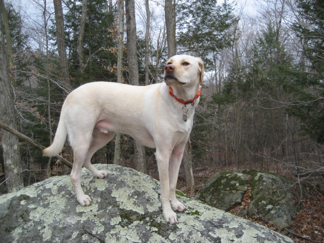
From Eric Armstrong Hill :), the trail descends (in some places it descends quickly) and, over the next mile it makes its way out to Old Springfield Road. Roscoe took a quick break to climb to the top of this rock. I don’t know if you can tell in the picture, but his body is even with my head (at about roughly six feet off the ground).
After hearing the bird the first time, I remembered thinking it was initially a Turkey Vulture. So, I started by looking up Turkey Vulture sounds…and, as it turns out, that bird lacks the vocal chords of other birds so they are unable to make calls. They make more of a low hissing sound. So, I quickly ruled out the Turkey Vulture. I spent another hour or so searching birds of prey. And, I found a great site run by The Cornell Lab of Ornithology (http://www.allaboutbirds.com). The site has pictures and calls of pretty much any bird I could think of that this bird might be (and many more). If you are interested in birds at all, I encourage you to check out the site.
Anyway, I continued to press on in my search. The sounds I had heard didn’t sound like any of the eagle or hawk calls on the site. I was about to give up when I stumbled upon the page with the Common Raven. I don’t remember exactly how I got there, but I immediately recognized the call…and I believed I had found my mystery bird.
My initial reaction was that the Raven would be too small for what I thought I had heard. I had originally thought that Ravens weren’t that big. But, as I continued to read up on them, I found that the Cornell Lab classifies them as “massive”. Perhaps my opinion of the raven was jaded because of my experience with crows, because I also thought ravens were more social. The Cornell Lab considers them, however, to be far less social than crows. It says they are usually found only in pairs. The most interesting tidbit I found during all of this Raven research is the fact they are considered among the smartest of all birds…and they are capable of many different kinds of calls (jackpot!). In some cases, ravens in captivity have even been taught words…truly fascinating stuff.
In the end, I decided that if these birds are capable of so many different sounds…and are able to learn to the point of mimicry…then that provides an explanation as to why the original calls I heard (back so many weeks before this hike) sounded mechanical in nature. I don’t think I’ll ever confirm that it was, in fact, a raven I had heard. But, based on my research, I’m 99.9% positive that it was. And, most importantly, I have a newfound appreciation for these birds. How something that is considered so common could escape my interest for so long is beyond me. But, now that I’m aware of just how fascinating these birds area, I can’t wait to learn more. I might even head back up to John Tom Hill to see if I can catch a glimpse of my new favorite bird.
Okay, now that I’ve spent four paragraphs and roughly 400 words on ravens, I think I’ll get back to talking about this hike…
The area around Eric Armstrong Hill :) is very close to the Massachusetts border. While I was on the hike, I was hopeful my journey had taken me into Massachusetts. But, when I got home, I discovered the trail misses it by a couple of miles. I would, eventually, break into Massachusetts on another hike…but that is another tale for another day.
From Eric Armstrong Hill :), the trail descends (in some places it descends quickly) and, over the next mile it makes its way out to Old Springfield Road. Roscoe took a quick break to climb to the top of this rock. I don’t know if you can tell in the picture, but his body is even with my head (at about roughly six feet off the ground).
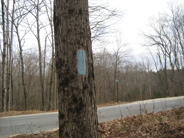
From what I could tell, Old Springfield Road marks the end of the line for now. The blaze on the tree in the picture below is the last blaze I could find in the area.
I think, eventually, the trail will head across Old Springfield Road and head east, off into the woods on the other side. For now, that was it for the Shenipsit. I could now say that I had walked (in sections) from East Hampton to within a few miles of the Massachusetts border. I thought it was pretty cool that I had completed the entire length of trail (including regional sections like Case Mountain and Gay City State Park) in roughly eight weeks…until I read about a couple of guys who ran the whole thing in one day. Proving (once again) that no matter how good you feel about yourself, there is always someone out there better than you. Regardless, I still think that my effort over the last two months (for a novice hiker) is pretty cool. What wasn’t cool was the journey back to my car.
From the final blaze just off of Old Springfield Road, I made a right and followed the road in a southeasterly direction for more than two miles. I slowly realized this was a mistake as I was adding unnecessary miles to my hike. If I had just turned around when I reached Old Springfield Road, and followed the trail back to my car, my total distance traveled would’ve been roughly ten miles. Instead, by following Old Springfield Road and Rt. 190, my total distance covered was closer to twelve miles. Also, you will see where eventually I got bored with tracking all of these road miles and turned off my MapMyHike app. But, I assure you, I did follow Old Springfield Road ALL the way to Rt. 190 and then followed Rt. 190 ALL the way back to Sodom Road.
Along Old Springfield Road, I stopped to take some pictures of the area around Kent Hollow Dam. In keeping with the theme of the day (birds), I heard and saw a beautiful Red-Tail Hawk. This one I recognized immediately (they are easy to spot because of their red tails) and, I tried to get a picture but all I got for kmy troubles was a blur.
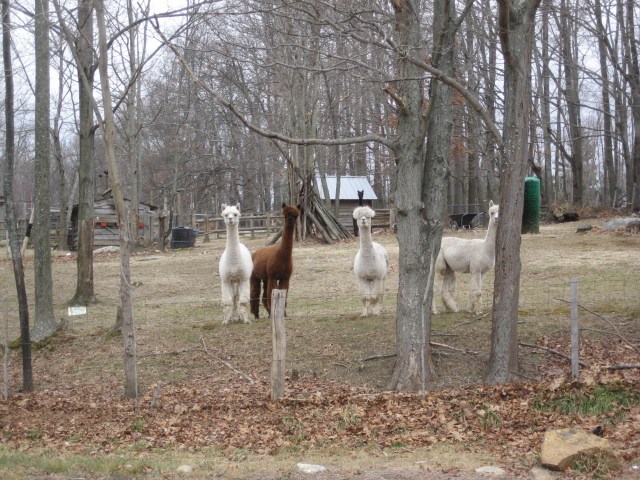
Later, once we made the turn onto Rt. 190, I also encountered some Alpacas. If you’ve never seen an alpaca before, check out the pictures below. These guys came bounding down the hill from the back of their fenced in area to check me and Roscoe out. Jaci and I agree that the white one with the fro is the coolest.
From the final blaze just off of Old Springfield Road, I made a right and followed the road in a southeasterly direction for more than two miles. I slowly realized this was a mistake as I was adding unnecessary miles to my hike. If I had just turned around when I reached Old Springfield Road, and followed the trail back to my car, my total distance traveled would’ve been roughly ten miles. Instead, by following Old Springfield Road and Rt. 190, my total distance covered was closer to twelve miles. Also, you will see where eventually I got bored with tracking all of these road miles and turned off my MapMyHike app. But, I assure you, I did follow Old Springfield Road ALL the way to Rt. 190 and then followed Rt. 190 ALL the way back to Sodom Road.
Along Old Springfield Road, I stopped to take some pictures of the area around Kent Hollow Dam. In keeping with the theme of the day (birds), I heard and saw a beautiful Red-Tail Hawk. This one I recognized immediately (they are easy to spot because of their red tails) and, I tried to get a picture but all I got for kmy troubles was a blur.
Later, once we made the turn onto Rt. 190, I also encountered some Alpacas. If you’ve never seen an alpaca before, check out the pictures below. These guys came bounding down the hill from the back of their fenced in area to check me and Roscoe out. Jaci and I agree that the white one with the fro is the coolest.
The remainder of this trip was pretty uneventful…although, we did almost get hit by several cars on Rt. 190. That was a lot of fun. I’m really not sure what compelled me to think that this road walk was a good idea, but I think I’m done with road walks for a while.
Eventually, we made our way back to Sodom Road and I turned left to follow the trail. A mile and a half later, we were back to the car.
I give these road walks a bad rap, but the truth is they allow me to cover a ton of miles more quickly than “woods miles”. For example, with the miles of road walking over this hike and my previous hike, I was able to cover more than 20 miles in a two-day period. I think, even with the majority of that being road miles, this is a pretty impressive feat. My hope is that I will someday build myself up enough to do 20 miles of actual hiking in a two-day period…and then, take it a step even further. I’m not exactly sure what my end goal is (other than the CT400). But, I think eventually I’d like to do the Appalachian Trail from start to finish. For now, I’ll just keep plugging away at these miles of the CT400.
Next stop: a familiar place not too far from home as I return to Case Mountain…and I’ll be sharing that journey with a new face (at least, new to this blog). The final hike of 2012 is next!