Hike #27
Stony Creek Quarry Preserve Trails
Date Hiked: 1/1/2013
Date Published: 1/22/2013
Disclaimer: This“re-cap” is more about the complications I experienced leading up to and on this hike, than it is about actual hiking.
For the first hike of 2013, I wanted to do something special. Originally, I had planned to save the hike up to Soapstone Mountain for New Year’s Day. But, later, it occurred to me that I should make that trip on a clear day in order to take full advantage of the view. So, I ended up making that trip sooner than I had originally planned. Now, I needed to find something else to do for New Year’s Day. And, complicating matters further, was the fact that we got about six inches of snow a few days before the end of 2012. So, my solution was to head down to the shoreline because they had a lot less snowfall than we did in the central region of the state. The morning of this hike, that seemed like a smart decision and I was looking forward to this hike. But, the truth is that this trip was doomed from the start.
In order to capture the complete mess that this hike became, I actually have to flash back to a few months earlier, which is when I received the Connecticut Forest & Park Association (CFPA) Walk Book. Flipping through it for the first time, I noticed the tangled mess that is the Stony Creek Quarry Preserve Trails and the Westwoods Trails. If you own the CFPA Walk Book, you know what I’m talking about. If you don’t, the only way I can explain it is to say that it is virtually impossible to tell where one trail ends and one trail begins. Complicating matters, for whatever reason, someone decided it was a good idea to blaze several trails with the same colors and differentiate between the two blazes by making one a square and one a rectangle. So, let me ask you…would you be confident in your ability to distinguish between a green square
and a green rectangle? So, my reaction at the time was to put these trails off for a bit until I felt more confident in my hiking ability.
Fast forward to New Year’s Day 2013 and I was confident that I could tell the trails apart. So, I loaded Roscoe into the car and we drove down I-91 to Guilford. I followed the map in the CFPA Walk Book to where it said there was a parking area. As I was pulling up the road near the
parking area, I encountered problem # 2. The small parking area had yet to be plowed. If I were in an SUV (like our new Jeep) or a truck, I would have no problem driving on the little bit of snow and parking where the map suggested. However, I was in my Charger and I know from experience it isn’t the best on snow and ice. It isn’t the worst car in snow, but I had a funny feeling about this trip. A funny feeling that I would later confirm…but we’ll get to that.
Right near the parking area is an independent senior living center known as The Gables. In hindsight, I guess I could have parked in their lot but it was marked as “employees only” and the few spots marked for visitor parking were right in front of the main entrance to the building. So, I knew that could mean trouble either way. I decided it was best to try one of the other parking areas on the CFPA map.
As I was driving over to the alternate parking area, I drove over a section of road where one of the trails crosses and noticed there was third parking area. So, I turned around and went back to that parking area…only to find that it hadn’t been plowed that well. I decided I would turn around again and keep heading over to the second parking area…only to get stuck. I spent the next ten to fifteen minutes digging myself out.
At this point, I really should have just turned around and gone home.
Eventually, I made my way over to the second parking area…which is off of Stony Creek Quarry Road in Branford. I saw what looked like a parking area, but it also didn’t look to be plowed too well. So, I kept driving down the road…only to realize that there was a fence and a gate,
which was closed and marked “No Trespassing”. I decided to back it out and make my way back to the area I had just passed. As I looked in my review mirror, I saw a cop car. I thought to myself that he responded quickly to my almost trespass, but then realized he was probably just making regular rounds. The parking area was littered with trash and a few of the boulders in the area were covered in graffiti. So, I’m sure he was just checking out the area. He left me alone and I…finally…was able to park and hit the trail. Complications over? Not quite...
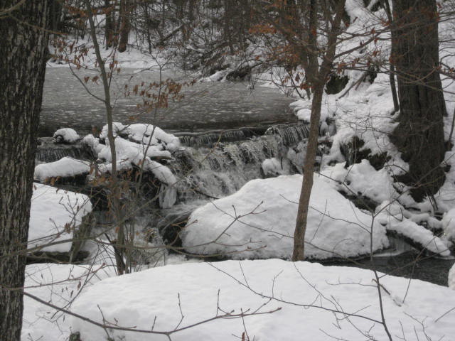
The first trail I attempted to hike is marked in the CFPA as a Green Rectangle, but the blazes don’t begin right away. There is a white circle on a few trees, which marks the trail, making it a sort-of access trail. The green blazes eventually begin after a short walk. I knew I was in the right area when I saw this waterfall.
Stony Creek Quarry Preserve Trails
Date Hiked: 1/1/2013
Date Published: 1/22/2013
Disclaimer: This“re-cap” is more about the complications I experienced leading up to and on this hike, than it is about actual hiking.
For the first hike of 2013, I wanted to do something special. Originally, I had planned to save the hike up to Soapstone Mountain for New Year’s Day. But, later, it occurred to me that I should make that trip on a clear day in order to take full advantage of the view. So, I ended up making that trip sooner than I had originally planned. Now, I needed to find something else to do for New Year’s Day. And, complicating matters further, was the fact that we got about six inches of snow a few days before the end of 2012. So, my solution was to head down to the shoreline because they had a lot less snowfall than we did in the central region of the state. The morning of this hike, that seemed like a smart decision and I was looking forward to this hike. But, the truth is that this trip was doomed from the start.
In order to capture the complete mess that this hike became, I actually have to flash back to a few months earlier, which is when I received the Connecticut Forest & Park Association (CFPA) Walk Book. Flipping through it for the first time, I noticed the tangled mess that is the Stony Creek Quarry Preserve Trails and the Westwoods Trails. If you own the CFPA Walk Book, you know what I’m talking about. If you don’t, the only way I can explain it is to say that it is virtually impossible to tell where one trail ends and one trail begins. Complicating matters, for whatever reason, someone decided it was a good idea to blaze several trails with the same colors and differentiate between the two blazes by making one a square and one a rectangle. So, let me ask you…would you be confident in your ability to distinguish between a green square
and a green rectangle? So, my reaction at the time was to put these trails off for a bit until I felt more confident in my hiking ability.
Fast forward to New Year’s Day 2013 and I was confident that I could tell the trails apart. So, I loaded Roscoe into the car and we drove down I-91 to Guilford. I followed the map in the CFPA Walk Book to where it said there was a parking area. As I was pulling up the road near the
parking area, I encountered problem # 2. The small parking area had yet to be plowed. If I were in an SUV (like our new Jeep) or a truck, I would have no problem driving on the little bit of snow and parking where the map suggested. However, I was in my Charger and I know from experience it isn’t the best on snow and ice. It isn’t the worst car in snow, but I had a funny feeling about this trip. A funny feeling that I would later confirm…but we’ll get to that.
Right near the parking area is an independent senior living center known as The Gables. In hindsight, I guess I could have parked in their lot but it was marked as “employees only” and the few spots marked for visitor parking were right in front of the main entrance to the building. So, I knew that could mean trouble either way. I decided it was best to try one of the other parking areas on the CFPA map.
As I was driving over to the alternate parking area, I drove over a section of road where one of the trails crosses and noticed there was third parking area. So, I turned around and went back to that parking area…only to find that it hadn’t been plowed that well. I decided I would turn around again and keep heading over to the second parking area…only to get stuck. I spent the next ten to fifteen minutes digging myself out.
At this point, I really should have just turned around and gone home.
Eventually, I made my way over to the second parking area…which is off of Stony Creek Quarry Road in Branford. I saw what looked like a parking area, but it also didn’t look to be plowed too well. So, I kept driving down the road…only to realize that there was a fence and a gate,
which was closed and marked “No Trespassing”. I decided to back it out and make my way back to the area I had just passed. As I looked in my review mirror, I saw a cop car. I thought to myself that he responded quickly to my almost trespass, but then realized he was probably just making regular rounds. The parking area was littered with trash and a few of the boulders in the area were covered in graffiti. So, I’m sure he was just checking out the area. He left me alone and I…finally…was able to park and hit the trail. Complications over? Not quite...
The first trail I attempted to hike is marked in the CFPA as a Green Rectangle, but the blazes don’t begin right away. There is a white circle on a few trees, which marks the trail, making it a sort-of access trail. The green blazes eventually begin after a short walk. I knew I was in the right area when I saw this waterfall.
I did my best to keep following the blazes, the CFPA Walk Book map, and the snow show tracks someone had previously left in the area. But, the going was extremely tough. The snow wasn’t deep…by any stretch. But, the blazes were few and far between, they didn’t seem to match up with what I was looking at on the map, and the person who previously went through with the snow shoes was all over the place. After getting “lost” a few times, I eventually made my way back a few hundred yards and decided to follow a different path. This new path looked more correct to me, so I followed it for a while and eventually made my way to where I could see a familiar building (The Gables). So, after all that driving and walking around in circles, I found an area that was somewhat familiar and I was able to orient myself. I was starting to make some progress. Complications over? Not even close...
From the area around The Gables, I made a left turn and started to follow the Orange Trail. For some reason, somebody decided it was a good
idea to blaze this trail as orange when heading west, but green when heading east. I didn’t have too much trouble with this. Where I did
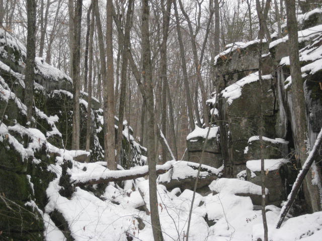
have trouble was when the trail came to an area of a brook, which created a small ravine. As we continued to make our way “west” (north), the ravine got narrower and narrower. We came to a couple of spots where I had to climb over some boulders. Roscoe was keeping up…for the most part.
From the area around The Gables, I made a left turn and started to follow the Orange Trail. For some reason, somebody decided it was a good
idea to blaze this trail as orange when heading west, but green when heading east. I didn’t have too much trouble with this. Where I did
have trouble was when the trail came to an area of a brook, which created a small ravine. As we continued to make our way “west” (north), the ravine got narrower and narrower. We came to a couple of spots where I had to climb over some boulders. Roscoe was keeping up…for the most part.
The first set of boulders weren’t overly challenging but I made Roscoe wait while I explored to verify the best path to take. He waited patiently (this is hard for him as he usually wants to charge ahead on these hikes) until I confirmed this was the best route and then told him to “come”. With the second set of boulders, he got a little over zealous and his curiosity got the best of him. Rather than listen to me and wait for me to verify the route, he followed right behind me up to a steep ledge. He made it up to the top of the section just fine. But, once I made my way down the other side, he thought it too steep and refused to follow.
I don’t know how long I spent trying to encourage him to come down, but it was a while. So, I eventually climbed back up to the top and went
back down the way we came…only to find out that he wasn’t comfortable going down that way either. We were out in the middle of the woods for what seemed like an eternity. No matter how hard I tried, I couldn’t come up with a solution to get him down. At one point, I
even went a few hundred yards down the trail (back in the direction we had come) to see if his urge to follow would overcome his fear to descend the rocky section.
After a few minutes passed, he began barking and crying so I had to go back. I again started trying to convince him that he could climb
down the way he had gone up…but he just wouldn’t cooperate.
The worst part of this whole scenario is that it really shouldn’t have been as hard as he was making it out to be. The highest part of the
rocky section was only a short jump down from the way we came (no higher than the jump down from our bed to the floor). And, the next "ledge" was no steeper than the stairs we have at home. Try as I might to confirm for him that this was just like being at home, he refused to make that initial first jump. I honestly lost track of time but it had to be like forty five minutes of trying to convince him to come down.
Finally, he came out on to the “ledge” far enough (with one front paw on a rock and the other on a small tree) where I could cradle him
in my arms and lower him to the “staircase” section. Given the position I was in, wedged between a boulder and a cliff (a literal rock and a hard place)…and keeping in mind that he weighs almost eighty pounds, I was proud of myself that I had the strength to lift him. From there, I was going to go down to the bottom of the ravine and try to do the same thing. But, before I could climb down, he scampered right down as if there was never any problem. I was so exhausted from the whole experience that, when I got to the bottom (again) myself, I collapsed and just
lay there for a few minutes to collect myself. I know this sounds dramatic but I, honestly, almost cried.
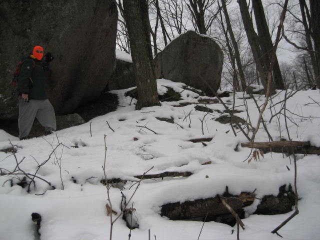
Needless to say, at this point, we were done. We still had about two miles to hike before we could get back to the car. But, we eventually made it and went home. Not before I took a quick minute to take this picture of me standing next to a huge boulder. I think I look pretty B.A.
So, this trip wasn’t a complete loss.
I don’t know how long I spent trying to encourage him to come down, but it was a while. So, I eventually climbed back up to the top and went
back down the way we came…only to find out that he wasn’t comfortable going down that way either. We were out in the middle of the woods for what seemed like an eternity. No matter how hard I tried, I couldn’t come up with a solution to get him down. At one point, I
even went a few hundred yards down the trail (back in the direction we had come) to see if his urge to follow would overcome his fear to descend the rocky section.
After a few minutes passed, he began barking and crying so I had to go back. I again started trying to convince him that he could climb
down the way he had gone up…but he just wouldn’t cooperate.
The worst part of this whole scenario is that it really shouldn’t have been as hard as he was making it out to be. The highest part of the
rocky section was only a short jump down from the way we came (no higher than the jump down from our bed to the floor). And, the next "ledge" was no steeper than the stairs we have at home. Try as I might to confirm for him that this was just like being at home, he refused to make that initial first jump. I honestly lost track of time but it had to be like forty five minutes of trying to convince him to come down.
Finally, he came out on to the “ledge” far enough (with one front paw on a rock and the other on a small tree) where I could cradle him
in my arms and lower him to the “staircase” section. Given the position I was in, wedged between a boulder and a cliff (a literal rock and a hard place)…and keeping in mind that he weighs almost eighty pounds, I was proud of myself that I had the strength to lift him. From there, I was going to go down to the bottom of the ravine and try to do the same thing. But, before I could climb down, he scampered right down as if there was never any problem. I was so exhausted from the whole experience that, when I got to the bottom (again) myself, I collapsed and just
lay there for a few minutes to collect myself. I know this sounds dramatic but I, honestly, almost cried.
Needless to say, at this point, we were done. We still had about two miles to hike before we could get back to the car. But, we eventually made it and went home. Not before I took a quick minute to take this picture of me standing next to a huge boulder. I think I look pretty B.A.
So, this trip wasn’t a complete loss.
It will be a while before I head back to Stony Creek. And, when I do, it will be under much better conditions…and, sadly, Roscoe will have to stay at home.
In closing, I wanted to share about my hiking goal for 2013. I’ve committed to hiking 365 miles this year. I still haven’t decided if this is too much or too little. At first glance, it is only a mile per day, which sounds simple enough. But, I don’t get the chance to hike every day. I hike
enough on the weekends where I could probably set a goal of two miles every day, but I also don’t hike every weekend. Additionally, after my experience hiking over the summer of 2012 in Rhode Island, I don’t know that I will do a lot of hiking over the summer of 2013. In the end, I think 365 miles is a realistic, attainable goal. We’ll see how it plays out. Regardless, even with all of the complications on this hike, I did actually cover a distance of 4.01 miles…bringing my goal for 2013 down to 360.99.
