Hike #29
Trail: Metacomet
Section: Hartford Reservoir #1 (off Rt. 4 in West Hartford, CT) to Hartford Reservoir # 6 (off Rt. 44 in West Hartford, CT)
Direction of Travel: South to North
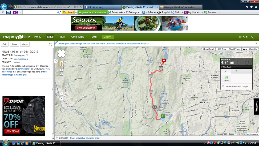
Distance: 4.96 miles
Approx Time to Complete: 2.5 hours
Date Hiked: 1/12/2013
Date Published: 1/24/2013
A few days before this hike, I posted a message on FaceBook to see if any of my friends wanted to join me. There was a pretty good initial response. And, while the actual turnout wasn’t as good as I expected based on the initial response, I was still joined by a handful of friends.
I think, at this point, it goes without saying that Roscoe was coming with me. But, in addition to my faithful furry friend, Jaci was going to make her quarterly appearance on these hikes (as more than just a hiking chauffeur this time). Also joining us would be my friend Eric (who I’ve known since I was about 5 years old…and, who was responsible for getting me back into playing softball last spring) and our friends Lauren and Kyle (who are also active hikers but, until now, I have not hiked with). I was excited for this “group hike” and I hope it is the first of many
more to come. I even have what I consider to be a whimsical name for these group hikes, which I will share if we ever make a common occurrence out of these things.
The gang met at our house around 9:15 in the morning and we made our way west to Reservoir #6, where we dropped all of the cars except for the Jeep. We loaded Roscoe into the back of the Jeep and the rest of us piled in. From there, we made our way due south to the parking area near Reservoir #1 and hit the trail shortly after 10:00.
The parking area, which is right off of Rt. 4 on the West Hartford / Farmington town line, is extremely large when compared to some of the
other spots I’ve left my car in the past. However, while it was an unseasonably warm day and the parking lot was maybe half full, it was also still the middle of winter. I imagine this parking area fills up quickly during the other seasons…especially during the height of the fall foliage.
We left the parking area and started out by making our way along the paved paths in the area. This reminded me of the Manchester Bike Trail.
The first half mile or so was more of a walk than it was a hike, but that was about to change.
As we made our way slightly uphill, I found the dirt road I had turned on to while hiking on Thanksgiving Day (Hike #16). On that hike, I had made my way up to The Kilkenny Rock Trail and turned around to head back to my car. On this hike, we would keep going all the way to Rt. 44. So, this first section of trail was familiar to me.
The first mile and a half of this hike is all climb. And, while it isn’t overly steep (MapMyHike has it at a Category 5 climb), I wouldn’t suggest it as a first hike for anyone who is just starting to get off of the couch. I think Jaci would agree as she quickly attempted to give up and head back to the safety of the Jeep. I encouraged her to keep going because I knew once we got to the top of the ridge the hike would level off. She kept going, with what I would call minimal complaining from that point on (even though there were several “are we almost there”s in my future). And, we all got a good laugh later when, upon completion, she said “that wasn’t so bad”.
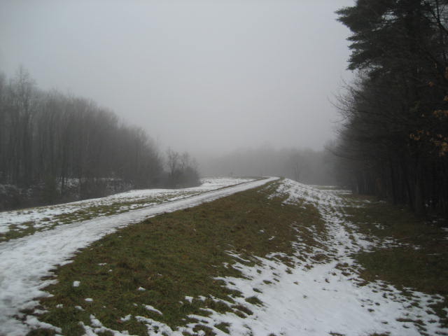
As promised, the trail leveled off after about a mile and half. We followed the top of the ridge for the next few miles. Somewhere in this stretch, we crossed a power line cut. I believe this to be the same power line cut I have crossed about a dozen times on the Metacomet since starting to make my way north from Plainville. Eventually, we came to some spots where, on a clearer day, we would have enjoyed some nice views (I swear I need to start saving these Metacomet hikes for clearer days). There were also some cool ups and downs in here but nothing overly
challenging.
Trail: Metacomet
Section: Hartford Reservoir #1 (off Rt. 4 in West Hartford, CT) to Hartford Reservoir # 6 (off Rt. 44 in West Hartford, CT)
Direction of Travel: South to North
Distance: 4.96 miles
Approx Time to Complete: 2.5 hours
Date Hiked: 1/12/2013
Date Published: 1/24/2013
A few days before this hike, I posted a message on FaceBook to see if any of my friends wanted to join me. There was a pretty good initial response. And, while the actual turnout wasn’t as good as I expected based on the initial response, I was still joined by a handful of friends.
I think, at this point, it goes without saying that Roscoe was coming with me. But, in addition to my faithful furry friend, Jaci was going to make her quarterly appearance on these hikes (as more than just a hiking chauffeur this time). Also joining us would be my friend Eric (who I’ve known since I was about 5 years old…and, who was responsible for getting me back into playing softball last spring) and our friends Lauren and Kyle (who are also active hikers but, until now, I have not hiked with). I was excited for this “group hike” and I hope it is the first of many
more to come. I even have what I consider to be a whimsical name for these group hikes, which I will share if we ever make a common occurrence out of these things.
The gang met at our house around 9:15 in the morning and we made our way west to Reservoir #6, where we dropped all of the cars except for the Jeep. We loaded Roscoe into the back of the Jeep and the rest of us piled in. From there, we made our way due south to the parking area near Reservoir #1 and hit the trail shortly after 10:00.
The parking area, which is right off of Rt. 4 on the West Hartford / Farmington town line, is extremely large when compared to some of the
other spots I’ve left my car in the past. However, while it was an unseasonably warm day and the parking lot was maybe half full, it was also still the middle of winter. I imagine this parking area fills up quickly during the other seasons…especially during the height of the fall foliage.
We left the parking area and started out by making our way along the paved paths in the area. This reminded me of the Manchester Bike Trail.
The first half mile or so was more of a walk than it was a hike, but that was about to change.
As we made our way slightly uphill, I found the dirt road I had turned on to while hiking on Thanksgiving Day (Hike #16). On that hike, I had made my way up to The Kilkenny Rock Trail and turned around to head back to my car. On this hike, we would keep going all the way to Rt. 44. So, this first section of trail was familiar to me.
The first mile and a half of this hike is all climb. And, while it isn’t overly steep (MapMyHike has it at a Category 5 climb), I wouldn’t suggest it as a first hike for anyone who is just starting to get off of the couch. I think Jaci would agree as she quickly attempted to give up and head back to the safety of the Jeep. I encouraged her to keep going because I knew once we got to the top of the ridge the hike would level off. She kept going, with what I would call minimal complaining from that point on (even though there were several “are we almost there”s in my future). And, we all got a good laugh later when, upon completion, she said “that wasn’t so bad”.
As promised, the trail leveled off after about a mile and half. We followed the top of the ridge for the next few miles. Somewhere in this stretch, we crossed a power line cut. I believe this to be the same power line cut I have crossed about a dozen times on the Metacomet since starting to make my way north from Plainville. Eventually, we came to some spots where, on a clearer day, we would have enjoyed some nice views (I swear I need to start saving these Metacomet hikes for clearer days). There were also some cool ups and downs in here but nothing overly
challenging.
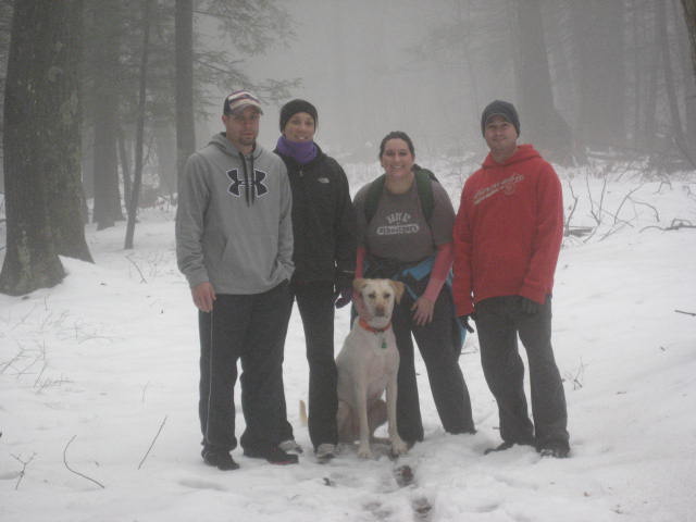
About three and a quarter miles in, the trail makes a hard right turn and starts heading east. It also starts to descend gradually. There are
a couple of more than gradual dips but, again, nothing overly challenging. We stopped somewhere in this stretch and my friend Eric took the picture below. Hiking pals!
a couple of more than gradual dips but, again, nothing overly challenging. We stopped somewhere in this stretch and my friend Eric took the picture below. Hiking pals!
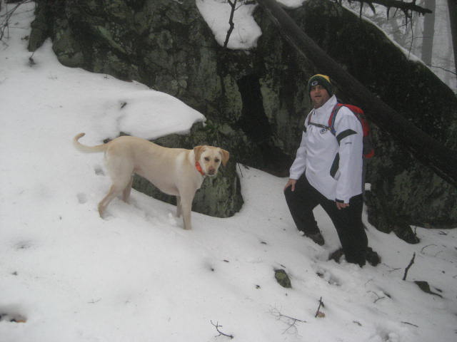
As we made our way down from the top of the ridge, we crossed the power line cut again. Make it a baker’s dozen!
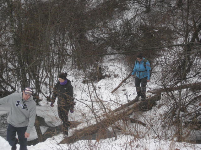
Just past the four mile mark of this hike, the trail crosses a stream. The humans used the make-shift bridge you see below to stay dry (although, at this point, I think all of our feet were soaked anyway). Roscoe decided to use the bridge to cross one way but then came back to
the group through the water/mud. Crazy dog!
After the stream, the trail followed along the top of a water control dyke for about a half of a mile or so.
Just before Rt. 44, the trail turns right and heads down off of the dyke. There is another small lot here but we had already left our cars on
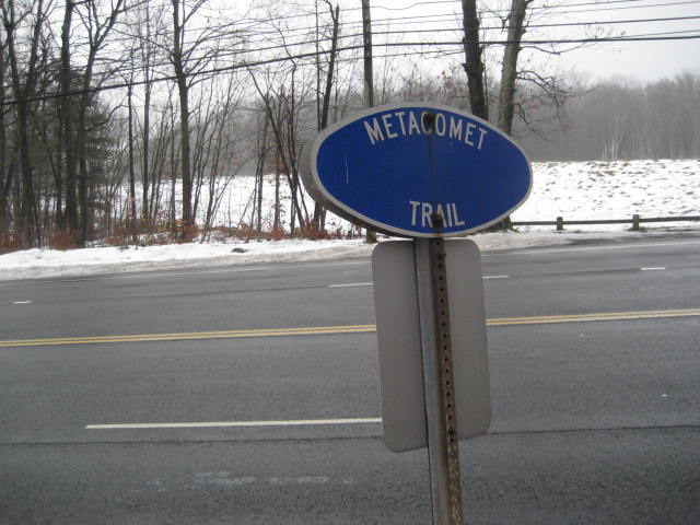
the other side of Rt. 44. So, we crossed the busy four-lane (two on each side) road and re-entered the woods on the other side. The picture below is looking back the way we came...after we had safely crossed.
the other side of Rt. 44. So, we crossed the busy four-lane (two on each side) road and re-entered the woods on the other side. The picture below is looking back the way we came...after we had safely crossed.
I was somewhat surprised when a small deer darted off into the woods not too far from our crossing. To begin with, I hadn’t seen any deer while hiking for a long time. And, we were fairly close to a very busy Rt. 44. But there she was…and there she went…off into the woods.
Shortly after crossing Rt. 44, we reached the point where the Metacomet makes a left turn and heads north past Reservoir #6. We could
continue on from there to Heublein Tower, but we would have to save that section of trail for another day. We doubled back to where we had left our cars two and half hours earlier. Lauren and Kyle went on their way. Jaci, Eric, Roscoe and I hopped in the Charger and the four of us made our way back over to Reservoir # 1 to pick up the Jeep (funny how it only took us a fraction of the time by car). From there, Eric, Roscoe and I made our way back to the house while Jaci went and picked up lunch at Noodles & Company (yummy!). Try as I might, I just can’t help myself when it comes to putting the calories I just burned off right back into my body.
Distance to 2013 Goal: 351.53