Hike #3
Metacomet & Penwood State Park Trails (Orange & Yellow)
Distance: 6.6 miles
Date Hiked: 11/11/2011
Date Published: 12/18/2012
Metacomet & Penwood State Park Trails (Orange & Yellow)
Distance: 6.6 miles
Date Hiked: 11/11/2011
Date Published: 12/18/2012
Veteran’s Day…2011. 11…11…11, if you will. I wasn’t originally planning to hike on this day. But, Jaci had to work and I was just sitting around the house with Roscoe. So, I decided to head out with him and see what the trail had to offer.
One of the bigger challenges with a lot of these hikes is that most of the trails only head in one direction. So, I either need to a.) leave my car at one trailhead and have Jaci drop me off at another or b.) find a way to make the hike into a “loop” hike. This isn’t always possible and often times, it leads to me travelling the same trail out and back. Not the biggest problem in life to have…but still something that needs to be addressed ahead of time. Fortunately for me (and for you, if you are just like me), there was a way to make this hike into a loop hike. You just have to get a little creative with it.
If you’ve ever hiked the Heublein Tower Trail, you are familiar with the area. The Penwood section of the Metacomet is actually right across the street (Rt. 185) from the Tower Trail. If you are heading West on 185, turn right (instead of turning left into the Tower Trail lot) and park in the parking area of Penwood State Park.
From the main park sign, I took a minute to grab one of the pocket maps they offer. I paid it forward later by returning the map for someone else to use...what a guy, huh? For the record, I already printed out a map at home but it was an 8-1/2 x 11 so the pocket-sized map seemed like an upgrade due to it being easier to pull out of my pocket whenever I needed...without having to unfold and re-fold.
I also took the time to read about the wildlife in the area, including bears…and, if you should encounter one, how best to deal with them. I’m always intrigued by these little commentaries on bear defense tactics. Oh sure, someone chose the tactic described in order to ward off the bear...and, congratulations to the person because it worked from them. But, what about the guy who did the same thing and didn’t live to tell the world that this particular tactic is only 50/50? Again, these are the things I think about in the middle of the woods when I'm by myself...or, in this case, with my dog...
From the lot, the trail starts by following a road. The road, which runs along the edge of Gale Pond, eventually leads deeper into the park. I’m not sure how far you can drive in, but why would you want to drive anyway? The trail only follows the road for a quarter of a mile before it heads up into the woods.
Almost immediately, we ran into the first fallen branch of the day (remember, this is still right around the time of the Snowpocalypse)…and it was a big one. After trying to go around it one way, I turned back and went around (through) it on the other side of the trail. Soon after, a trail runner passed me and I was impressed. Keep in mind, at the time I’m pushing 350 pounds so the thought of running at all was disturbing…and, I was struggling to walk up and down these trails. Running them was about the farthest thing from my mind. Later, she would pass me going back the other way…leaving me to ponder exactly how far she had run in that short amount of time. For all I knew, she ran all the way up to the border of Massachusetts and back. Not likely, but who am I to judge...
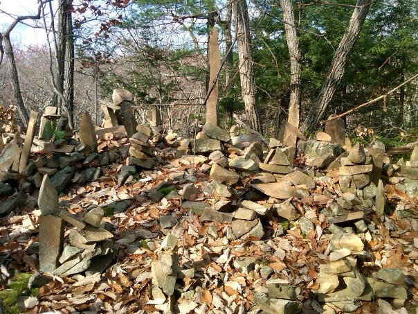
Along the first section of trail, there is a short side trail to the left that leads to the rock formation you see in the picture above. The formation is easy to see from the main trail so you won’t miss it. I snapped the picture you see and uploaded it to Facebook stating it was “man-made”. Later, my high school friend Charlie would ask how I knew it was “man-made”…and he has a point. For all I know, aliens created this little formation in the middle of the woods of Connecticut. Regardless of whom (what) created this…man, aliens, or some other unknown force…I think it is pretty cool. The picture doesn’t really capture the detail. So, if you want to see a better version…get out to the trail and check it out for yourself.
Eventually, about a mile and three quarters into the hike, the trail gradually descends down to Lake Louise. There is a “dock” which allows you to walk a short stretch out into the lake. I chuckled at Roscoe as he tried to bend his neck down from the dock in order to get close enough to the water to have a drink. First, I always carry enough water for both of us. At the time, I was still even carrying his dog bowl in my pack. Why did I stop bringing his bowl with me? Oh, we'll get to that when I recap one of our later hikes. For now, let's just say my upper back still hurts thinking about it. I assure you that he gets more than enough water on these trips. More importantly, though, I laughed because he reminded me of a Giraffe you might see on Animal Planet, trying to get a drink from a watering hole in the Serengeti. I explained to him, using logic (which he hates so much), that he could easily trot back to the beginning of the dock and get a drink of water right from the shoreline of the lake. I also explained to him that it wouldn't be the best thing for him and that he should just drink the water I packed (a solution he has still not come to grasp to this day...as he can often be found drinking the muddy water from the tire tracks left by Jeeps/ATVs...no matter how hard I try to get him to stop, he still does it). All I got in return for my logical reasoning was a scoff. So, we trekked on.
From here, the trail runs along the lake for a short stretch and then goes up, up, up a steep incline. Someone (thing?) was kind enough to build steps out of rocks so the incline isn’t as difficult as it could be. But, that doesn’t mean it isn’t challenging. I’m interested to re-explore this area of the trail now that I completely trust Roscoe enough to let him off leash. I could just see in his eyes that he wanted to climb this section as quickly as possible but I was slowing him down.
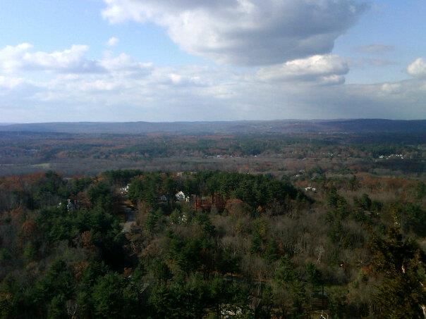
Once you reach the top, you stay along the ridge for quite a while (maybe a mile or so). And, you eventually reach another of the infamous Connecticut “Pinnacles”. For those of you who haven’t read through my other hike recaps, I wrote about one of the other “Pinnacles” on another section of the same Metacomet Trail, down in Plainville. This “Pinnacle” overlooks the town of Simsbury which, from above, looks like a sleepy little town…the highest point of which is a church steeple. It was very calm and quiet…except for the wind, which is always loudest at these high overlooks. Personally, I think the view from this Pinnacle the nicer of the two I’ve experienced so far.
From the viewpoint, the trail starts to make its way down, down, down. Slowly at first, but just before reaching Wintonbury Road (at about 3.3 miles), it gets really steep. The road is partially paved but, as it crosses the ridge into Bloomfield, it becomes a dirt road. If we had played the commuter car shuffle game, this is where I would've dropped off my car. And, this is where I will eventually have Jaci drop me off when I’m ready to tackle the next section. Instead, we were forced to turn back and head the other way. Fortunately, I had planned ahead. So I knew that, not too far down the road on the left, there is an orange blazed trail which leads back to where I did actually park. Unfortunately, due to the aforementioned Snowpocalypse, the dirt road section of Wintonbury Road was covered (and I mean covered) with fallen branches.
After we made our way through what I can only assume was the Town of Simsbury Fallen Branch Dumping Grounds, we hit the Orange-Blazed Trail and followed that for a little more than mile back to Lake Louise. The trail through here is nice but it basically follows the same ridgeline as the blue-blazed Metacomet, only much closer to the valley. If I had to guess I would say we were probably about halfway up the ridge, where as the Metacomet Trail on the way out followed the top of the ridge line. It was a nice change of pace, but the views aren’t nearly as nice at this level. It was also around this time that I noticed the first (yes, there will be more) pair of ticks on Roscoe.
People who aren’t from this area don’t understand just how much of a pest these ticks can be. They are nasty! Hate isn’t a word I throw around casually, but I can say…without hesitation…that I hate them! If you aren’t familiar with ticks, they are basically small spiders…that suck blood and transmit diseases like mosquitoes…and they are nearly impossible to kill. If a mosquito is biting you, you feel it and you slap yourself to kill it. It makes a bloody mess and, later, you will have an itchy bump. But that is a small price to pay compared to what ticks can do. First, if I tick is feasting on you, you are likely to not even know it. They secrete a pain killer so that the immediate area is numb to the pain of their bite. And, once they are in your skin, good luck getting them out. People try all kinds of crazy things…like burning them (which can also burn your skin), putting rubbing alcohol on them, and pulling them out with tweezers. Either way, you have to make sure the head comes out otherwise you could end up with infection. So, like I said…they are nasty and I hate them. I would’ve preferred to encounter those bears I was warned about.
The Orange Trail eventually runs into a semi-paved road that circles the other side of Lake Louise from the one I trekked earlier. And, the semi-paved road eventually runs into the Yellow Trail. From the Yellow Trail, we enjoyed some more view points. The views here are actually better than the views from the first section of the Metacomet in Penwood, since most of those views are obscured by trees. But, they still don’t beat the view from The Pinnacle. We made our way back and forth from the “road” to the ridgeline so I didn’t exactly stick to the true Yellow Trail the whole way out. But, eventually the road brought us back to the parking lot and to my car.
On the way home, I had to stop to pick a few more ticks off of Roscoe. Then, once we got home, I checked him over again and there were a few more. I lost count after 13. 13 ticks! That has to be some kind of record! Sadly, it should have been 14. As I was walking him the next day, I found another one which had swelled up. For those of you aren’t familiar, once they swell up from the blood they’ve been feasting on they look similar to a corn kernel…only silver. As with humans, there is a threat of disease when they bite our pets, but we were fortunate in that he never showed any signs of anything resulting from this bite.
When we got back from our regular walk that next morning, I plucked this last one off of him…and vowed never to hike again...
One of the bigger challenges with a lot of these hikes is that most of the trails only head in one direction. So, I either need to a.) leave my car at one trailhead and have Jaci drop me off at another or b.) find a way to make the hike into a “loop” hike. This isn’t always possible and often times, it leads to me travelling the same trail out and back. Not the biggest problem in life to have…but still something that needs to be addressed ahead of time. Fortunately for me (and for you, if you are just like me), there was a way to make this hike into a loop hike. You just have to get a little creative with it.
If you’ve ever hiked the Heublein Tower Trail, you are familiar with the area. The Penwood section of the Metacomet is actually right across the street (Rt. 185) from the Tower Trail. If you are heading West on 185, turn right (instead of turning left into the Tower Trail lot) and park in the parking area of Penwood State Park.
From the main park sign, I took a minute to grab one of the pocket maps they offer. I paid it forward later by returning the map for someone else to use...what a guy, huh? For the record, I already printed out a map at home but it was an 8-1/2 x 11 so the pocket-sized map seemed like an upgrade due to it being easier to pull out of my pocket whenever I needed...without having to unfold and re-fold.
I also took the time to read about the wildlife in the area, including bears…and, if you should encounter one, how best to deal with them. I’m always intrigued by these little commentaries on bear defense tactics. Oh sure, someone chose the tactic described in order to ward off the bear...and, congratulations to the person because it worked from them. But, what about the guy who did the same thing and didn’t live to tell the world that this particular tactic is only 50/50? Again, these are the things I think about in the middle of the woods when I'm by myself...or, in this case, with my dog...
From the lot, the trail starts by following a road. The road, which runs along the edge of Gale Pond, eventually leads deeper into the park. I’m not sure how far you can drive in, but why would you want to drive anyway? The trail only follows the road for a quarter of a mile before it heads up into the woods.
Almost immediately, we ran into the first fallen branch of the day (remember, this is still right around the time of the Snowpocalypse)…and it was a big one. After trying to go around it one way, I turned back and went around (through) it on the other side of the trail. Soon after, a trail runner passed me and I was impressed. Keep in mind, at the time I’m pushing 350 pounds so the thought of running at all was disturbing…and, I was struggling to walk up and down these trails. Running them was about the farthest thing from my mind. Later, she would pass me going back the other way…leaving me to ponder exactly how far she had run in that short amount of time. For all I knew, she ran all the way up to the border of Massachusetts and back. Not likely, but who am I to judge...
Along the first section of trail, there is a short side trail to the left that leads to the rock formation you see in the picture above. The formation is easy to see from the main trail so you won’t miss it. I snapped the picture you see and uploaded it to Facebook stating it was “man-made”. Later, my high school friend Charlie would ask how I knew it was “man-made”…and he has a point. For all I know, aliens created this little formation in the middle of the woods of Connecticut. Regardless of whom (what) created this…man, aliens, or some other unknown force…I think it is pretty cool. The picture doesn’t really capture the detail. So, if you want to see a better version…get out to the trail and check it out for yourself.
Eventually, about a mile and three quarters into the hike, the trail gradually descends down to Lake Louise. There is a “dock” which allows you to walk a short stretch out into the lake. I chuckled at Roscoe as he tried to bend his neck down from the dock in order to get close enough to the water to have a drink. First, I always carry enough water for both of us. At the time, I was still even carrying his dog bowl in my pack. Why did I stop bringing his bowl with me? Oh, we'll get to that when I recap one of our later hikes. For now, let's just say my upper back still hurts thinking about it. I assure you that he gets more than enough water on these trips. More importantly, though, I laughed because he reminded me of a Giraffe you might see on Animal Planet, trying to get a drink from a watering hole in the Serengeti. I explained to him, using logic (which he hates so much), that he could easily trot back to the beginning of the dock and get a drink of water right from the shoreline of the lake. I also explained to him that it wouldn't be the best thing for him and that he should just drink the water I packed (a solution he has still not come to grasp to this day...as he can often be found drinking the muddy water from the tire tracks left by Jeeps/ATVs...no matter how hard I try to get him to stop, he still does it). All I got in return for my logical reasoning was a scoff. So, we trekked on.
From here, the trail runs along the lake for a short stretch and then goes up, up, up a steep incline. Someone (thing?) was kind enough to build steps out of rocks so the incline isn’t as difficult as it could be. But, that doesn’t mean it isn’t challenging. I’m interested to re-explore this area of the trail now that I completely trust Roscoe enough to let him off leash. I could just see in his eyes that he wanted to climb this section as quickly as possible but I was slowing him down.
Once you reach the top, you stay along the ridge for quite a while (maybe a mile or so). And, you eventually reach another of the infamous Connecticut “Pinnacles”. For those of you who haven’t read through my other hike recaps, I wrote about one of the other “Pinnacles” on another section of the same Metacomet Trail, down in Plainville. This “Pinnacle” overlooks the town of Simsbury which, from above, looks like a sleepy little town…the highest point of which is a church steeple. It was very calm and quiet…except for the wind, which is always loudest at these high overlooks. Personally, I think the view from this Pinnacle the nicer of the two I’ve experienced so far.
From the viewpoint, the trail starts to make its way down, down, down. Slowly at first, but just before reaching Wintonbury Road (at about 3.3 miles), it gets really steep. The road is partially paved but, as it crosses the ridge into Bloomfield, it becomes a dirt road. If we had played the commuter car shuffle game, this is where I would've dropped off my car. And, this is where I will eventually have Jaci drop me off when I’m ready to tackle the next section. Instead, we were forced to turn back and head the other way. Fortunately, I had planned ahead. So I knew that, not too far down the road on the left, there is an orange blazed trail which leads back to where I did actually park. Unfortunately, due to the aforementioned Snowpocalypse, the dirt road section of Wintonbury Road was covered (and I mean covered) with fallen branches.
After we made our way through what I can only assume was the Town of Simsbury Fallen Branch Dumping Grounds, we hit the Orange-Blazed Trail and followed that for a little more than mile back to Lake Louise. The trail through here is nice but it basically follows the same ridgeline as the blue-blazed Metacomet, only much closer to the valley. If I had to guess I would say we were probably about halfway up the ridge, where as the Metacomet Trail on the way out followed the top of the ridge line. It was a nice change of pace, but the views aren’t nearly as nice at this level. It was also around this time that I noticed the first (yes, there will be more) pair of ticks on Roscoe.
People who aren’t from this area don’t understand just how much of a pest these ticks can be. They are nasty! Hate isn’t a word I throw around casually, but I can say…without hesitation…that I hate them! If you aren’t familiar with ticks, they are basically small spiders…that suck blood and transmit diseases like mosquitoes…and they are nearly impossible to kill. If a mosquito is biting you, you feel it and you slap yourself to kill it. It makes a bloody mess and, later, you will have an itchy bump. But that is a small price to pay compared to what ticks can do. First, if I tick is feasting on you, you are likely to not even know it. They secrete a pain killer so that the immediate area is numb to the pain of their bite. And, once they are in your skin, good luck getting them out. People try all kinds of crazy things…like burning them (which can also burn your skin), putting rubbing alcohol on them, and pulling them out with tweezers. Either way, you have to make sure the head comes out otherwise you could end up with infection. So, like I said…they are nasty and I hate them. I would’ve preferred to encounter those bears I was warned about.
The Orange Trail eventually runs into a semi-paved road that circles the other side of Lake Louise from the one I trekked earlier. And, the semi-paved road eventually runs into the Yellow Trail. From the Yellow Trail, we enjoyed some more view points. The views here are actually better than the views from the first section of the Metacomet in Penwood, since most of those views are obscured by trees. But, they still don’t beat the view from The Pinnacle. We made our way back and forth from the “road” to the ridgeline so I didn’t exactly stick to the true Yellow Trail the whole way out. But, eventually the road brought us back to the parking lot and to my car.
On the way home, I had to stop to pick a few more ticks off of Roscoe. Then, once we got home, I checked him over again and there were a few more. I lost count after 13. 13 ticks! That has to be some kind of record! Sadly, it should have been 14. As I was walking him the next day, I found another one which had swelled up. For those of you aren’t familiar, once they swell up from the blood they’ve been feasting on they look similar to a corn kernel…only silver. As with humans, there is a threat of disease when they bite our pets, but we were fortunate in that he never showed any signs of anything resulting from this bite.
When we got back from our regular walk that next morning, I plucked this last one off of him…and vowed never to hike again...