Hike #30
Bigelow Hollow Trails (East Ridge Trail, Breakneck Pond View Trail)
Distance: 6.86 miles
Approx Time to Complete: 3.5 hours
Date Hiked: 1/13/2013
Date Published: 1/25/2013
If I had a dollar for every one of these blogs I posted that included the phrase “my original plan”, I would have roughly twenty dollars by now. I might have mentioned this before, but I think that my number one piece of advice to anyone who is just starting out would be to have a map, and be ready to change plans at a moment’s notice.
So…”my original plan” with this hike was to follow the East Ridge Trail out and take the Ridge Trail back. I was in need of some elevation and
wanted to experience the 990 foot Peter Rabbit Rock. However, I missed the turn off for the Ridge Trail (I still don’t know how). And, I ended up taking the Breakneck Pond View Trail back…but I’m getting way ahead of myself.
Bigelow Hollow State Park, located in Union, Connecticut is roughly 3.5 miles from I-84 (exit 73). Within the area of Bigelow Hollow are three large ponds (Bigelow Pond, Mashapaug Pond and Breakneck Pond). The trails through the area, of which there are six (totaling approximately 20 miles), allow hikers to explore the shores of these ponds or climb to cliffs overlooking them. These trails include the Nipmuck Trail, which makes its way north from Mansfield…approximately 30 miles away. Certain trails, like the Breakneck Pond View Trail and the Ridge Trail
(not to be confused with the East Ridge Trail) also cross the state border into Massachusetts.
When planning for this hike, I did my best to avoid the blue-blazed Nipmuck Trail because I wanted to save it for last and experience the sections of that trail to the south first (from the “beginning”, if you will). Going forward, I’m doing my best to experience these “long-distance” trails from beginning to end…instead of starting in the middle like I did with the Metacomet and the Shenipsit. For now, I was just looking for a place to do a loop hike. So, I planned to start by hiking the East Ridge Trail, which would eventually lead me to the Breakneck Pond View Trail. I then planned to hike the Breakneck Pond View Trail for about a half of a mile, before making a right turn and heading back along the Ridge
Trail.
I was excited that, for the first time, I was going to hike over the state border into Massachusetts.
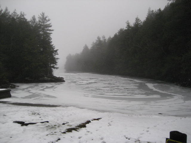
After a 30 to 40 minute drive from the house, I arrived at Bigelow Hollow to find that the parking area I originally choose was still covered with snow (here we go again…I really need to start bringing the Jeep). I drove around for a bit, looking for a better spot. There are several other parking areas in the park, but nothing looked good enough to me. So, I made my way to the far end of the park road and parked in the area of the Mashapaug Pond Boat Launch. This is, I think, the best parking area in the park. I got out and took a picture of the pond from the boat launch.
Bigelow Hollow Trails (East Ridge Trail, Breakneck Pond View Trail)
Distance: 6.86 miles
Approx Time to Complete: 3.5 hours
Date Hiked: 1/13/2013
Date Published: 1/25/2013
If I had a dollar for every one of these blogs I posted that included the phrase “my original plan”, I would have roughly twenty dollars by now. I might have mentioned this before, but I think that my number one piece of advice to anyone who is just starting out would be to have a map, and be ready to change plans at a moment’s notice.
So…”my original plan” with this hike was to follow the East Ridge Trail out and take the Ridge Trail back. I was in need of some elevation and
wanted to experience the 990 foot Peter Rabbit Rock. However, I missed the turn off for the Ridge Trail (I still don’t know how). And, I ended up taking the Breakneck Pond View Trail back…but I’m getting way ahead of myself.
Bigelow Hollow State Park, located in Union, Connecticut is roughly 3.5 miles from I-84 (exit 73). Within the area of Bigelow Hollow are three large ponds (Bigelow Pond, Mashapaug Pond and Breakneck Pond). The trails through the area, of which there are six (totaling approximately 20 miles), allow hikers to explore the shores of these ponds or climb to cliffs overlooking them. These trails include the Nipmuck Trail, which makes its way north from Mansfield…approximately 30 miles away. Certain trails, like the Breakneck Pond View Trail and the Ridge Trail
(not to be confused with the East Ridge Trail) also cross the state border into Massachusetts.
When planning for this hike, I did my best to avoid the blue-blazed Nipmuck Trail because I wanted to save it for last and experience the sections of that trail to the south first (from the “beginning”, if you will). Going forward, I’m doing my best to experience these “long-distance” trails from beginning to end…instead of starting in the middle like I did with the Metacomet and the Shenipsit. For now, I was just looking for a place to do a loop hike. So, I planned to start by hiking the East Ridge Trail, which would eventually lead me to the Breakneck Pond View Trail. I then planned to hike the Breakneck Pond View Trail for about a half of a mile, before making a right turn and heading back along the Ridge
Trail.
I was excited that, for the first time, I was going to hike over the state border into Massachusetts.
After a 30 to 40 minute drive from the house, I arrived at Bigelow Hollow to find that the parking area I originally choose was still covered with snow (here we go again…I really need to start bringing the Jeep). I drove around for a bit, looking for a better spot. There are several other parking areas in the park, but nothing looked good enough to me. So, I made my way to the far end of the park road and parked in the area of the Mashapaug Pond Boat Launch. This is, I think, the best parking area in the park. I got out and took a picture of the pond from the boat launch.
Parking where I did would add some extra distance to my hike (road walk), but I was okay with that. I was feeling ambitious. My MapMyHike app, however, was not. It was an overcast day so I was having a hard time connecting to GPS…which means, no map of my hike. No big deal. If anything, I had read that the cell phone reception within the park was limited so this would allow me to save my battery in the event I needed to make an emergency call.
The description in the CFPA Walk Book of the Ridge Trail makes it sound very rugged. So, I printed a map from the Bigelow Hollow State Park website and left it for Jaci. That way, if something happened to me or Roscoe, she would know exactly where we were.
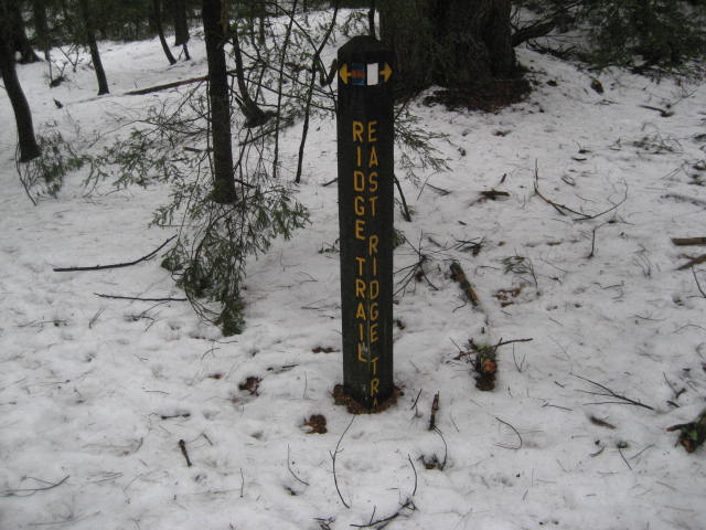
On the road walk from the parking area to the Ridge Trail / East Ridge Trail connector, I kept trying to get my MapMyHike app to work, but I
eventually gave up. From the park road, I made a left into the woods and eventually came to this sign, which marks the beginning of both the Ridge Trail and the East Ridge Trail.
The description in the CFPA Walk Book of the Ridge Trail makes it sound very rugged. So, I printed a map from the Bigelow Hollow State Park website and left it for Jaci. That way, if something happened to me or Roscoe, she would know exactly where we were.
On the road walk from the parking area to the Ridge Trail / East Ridge Trail connector, I kept trying to get my MapMyHike app to work, but I
eventually gave up. From the park road, I made a left into the woods and eventually came to this sign, which marks the beginning of both the Ridge Trail and the East Ridge Trail.
We kept going straight and followed the East Ridge Trail (white-blazed). About a quarter of a mile in, the trail makes a left turn and heads north, following an old woods road. There are several woods roads through the park but the trails do a really good job of avoiding them where they can. The East Ridge Trail, however, follows this woods road for about a mile before it comes to the first intersection with the Breakneck Pond Trail (to the left). We kept following the woods road to the right and, shortly after, came to an area marked on the map as a helicopter landing zone. Back when I first saw this on the map, it made me concerned about what I might find deeper in the park. With names like “Breakneck” Pond and a helicopter landing zone, I was beyond just a little worried.
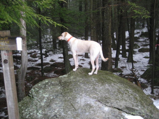
The area around the helicopter landing zone is basically a big field, shaped like a circle. Here, the East Ridge Trail crosses the Nipmuck Trail. I had to take a few seconds to locate the East Ridge Trail, since the sign was obscured by a tree in the area. Look for the rock Roscoe is standing
on in the picture below and you’ll find it.
From the area around the helicopter landing zone, the trail ascends the ridge and follows it (for the most part) for the next mile and a half. There are some drops and some re-climbs in the area, but nothing overly challenging. I was fine and I was even dealing with a good amount of snow. It was obvious that not many people had traveled this trail since the last time it snowed. There was one set of footprints, which I followed (for the most part). But, it was also clear that this person wasn’t sure of where they were going. So, I kept an eye out for the blazes.
The trail eventually crosses an unpaved road and, when it re-enters the woods on the other side, it is surrounded by laurel. At one point in this
section, I climbed over a fallen pine tree and gashed my leg pretty good…but it wasn’t anything a little peroxide over the next few days couldn’t fix.
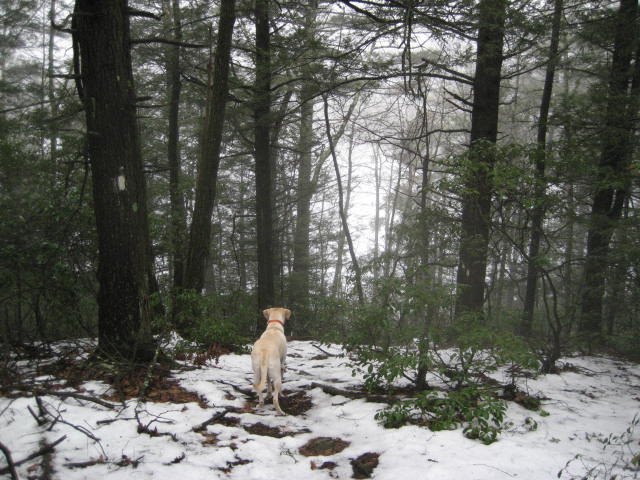
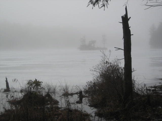
Half a mile after we crossed the unpaved road in the middle of the woods, we reached the Breakneck Pond overlook. We stopped to enjoy the (limited) view and I took the picture below.
The trail eventually crosses an unpaved road and, when it re-enters the woods on the other side, it is surrounded by laurel. At one point in this
section, I climbed over a fallen pine tree and gashed my leg pretty good…but it wasn’t anything a little peroxide over the next few days couldn’t fix.
Half a mile after we crossed the unpaved road in the middle of the woods, we reached the Breakneck Pond overlook. We stopped to enjoy the (limited) view and I took the picture below.
I’m not sure if you can tell from that picture, but the trail pretty much drops off. The CFPA Walk Book describes this as a “descent”, but if
you aren’t careful it is really more of a fall. We took our time, as you should, and eventually reached an unpaved road on the eastern edge of Breakneck Pond.
Here, the East Ridge Trail ends. To the left is the northern terminus of the Nipmuck Trail. And, to the right, is the northern terminus of the Breakneck Pond View Trail (although that trail continues further north). I took a minute here to catch my breath after the steep descent and noticed the stone marker on the side of the unpaved road.
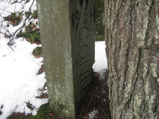
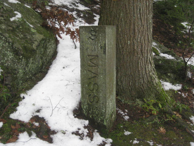
At this point, I was officially “hiking” in Massachusetts…never mind the fact that I was really just
walking down a dirt road.
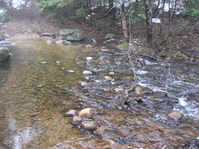
From the area of the stone state boundary marker, I followed the unpaved road north for about a tenth of a mile before I reached the north end of Breakneck Pond. I made a left turn, following the blue and white blazes over the dam listed on the CFPA map. I continued to follow the Breakneck Pond View Trail to where I planned to meet up with the Ridge Trail. But, somehow, I missed the turn. I think it had something to do with this wide stream crossing that is in the area.
From the area of the stone state boundary marker, I followed the unpaved road north for about a tenth of a mile before I reached the north end of Breakneck Pond. I made a left turn, following the blue and white blazes over the dam listed on the CFPA map. I continued to follow the Breakneck Pond View Trail to where I planned to meet up with the Ridge Trail. But, somehow, I missed the turn. I think it had something to do with this wide stream crossing that is in the area.
Regardless, by the time I realized I had missed the turn; I was already too far south along the Breakneck Pond View Trail. So, I decided to just take the Breakneck Pond View Trail south until I ran back into the intersection with the East Ridge Trail. The Breakneck Pond View Trail follows the western edge of Breakneck Pond, but it doesn’t always stick right to the edge. There were a few points where it climbs to a pretty good view of the pond.
As we got closer to the end of the trail, there were some rocky parts. After my experience with the rocky ledges on the Stony Creek Preserve Trails, I was worried Roscoe wouldn’t be able to follow. But, he was a champ. And, after he was done climbing over the somewhat difficult sections, he took some well-deserved free time to test the strength of the ice covering the pond. Disney Presents: Roscoe on Ice!
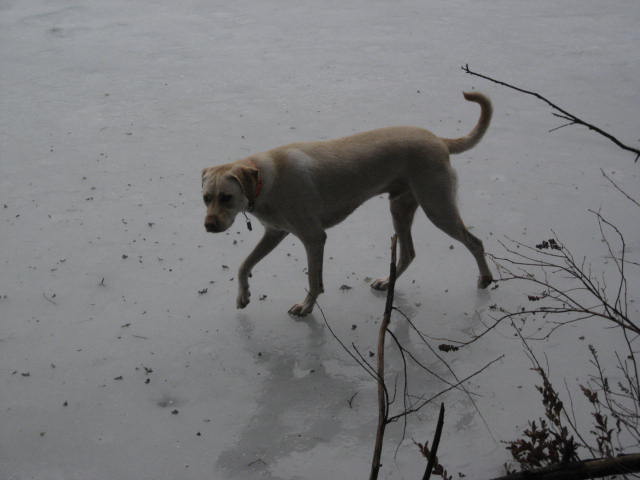
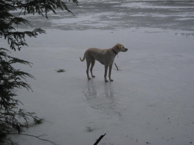
For anyone who might be concerned about him falling through, I only took the pictures because I was already in the process of taking my phone and camera out of my pocket in the event I had to go in after him. Fortunately, he would live to skate another day. Thank you for your concern, though!
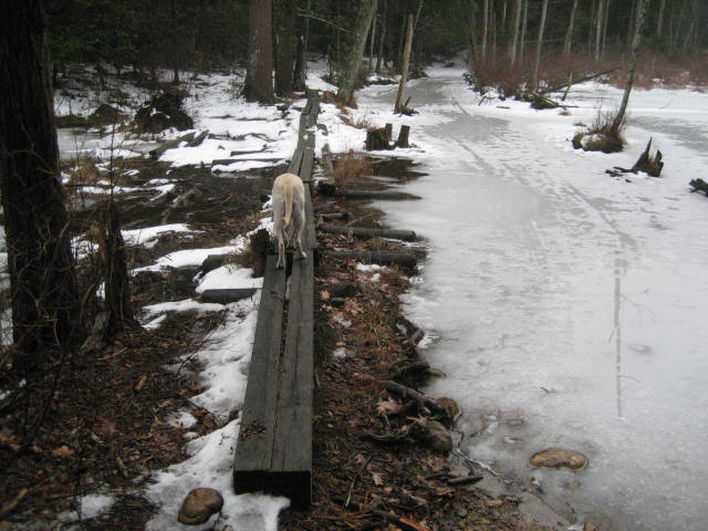
After the rocky sections, we eventually came to these bog bridges…which I through were cool.
After the rocky sections, we eventually came to these bog bridges…which I through were cool.
The whole Breakneck Pond View Trail experience was a nice one. The trail is about two and quarter miles (start to finish) and it offers a lot. I was disappointed I missed the turn off for the Ridge Trail (and Peter Rabbit Rock), but I knew I would experience that trail in due time.
From the Breakneck Pond View Trail, I followed the southern sections of the East Ridge Trail and the park road back to my car.
Distance to 2013 Goal: 344.67
From the Breakneck Pond View Trail, I followed the southern sections of the East Ridge Trail and the park road back to my car.
Distance to 2013 Goal: 344.67
