Hike #31
Case Mountain Trails (White, Blue, Red, Yellow/Red, Grey/White, Pink, Yellow)
Date Hiked: 1/18/2013
Date Published: 1/27/2013
Case Mountain Trails (White, Blue, Red, Yellow/Red, Grey/White, Pink, Yellow)
Date Hiked: 1/18/2013
Date Published: 1/27/2013
Friday, January 18th. The Friday before Martin Luther King Day. I had taken the day off because Jaci was having a minor medical procedure. It wasn't anything overly serious, but serious enough that they would have to put her under and I would have to drive her home. I wasn't even sure I would be hiking on this day. But, when we got home from her appointment, she said she was feeling well enough for me to go. Still, I didn't went to venture off too far in the event that she needed me to give her a ride somewhere. Case Mountain it is!
I packed up my gear (remembering my camera this time), loaded Roscoe into the Jeep and we headed out. That's right, I was taking the Jeep this time. So, I don't need to spend too many words on parking attempts.
Those of you who remember the last time I was on these trails (Hike #28), might recall that I wasn't feeling well before that hike. So, I had to cut that hike a bit short (if you want to call 4.5 miles while recovering from the flu "short"). Anyway, my plan this time was to hit up the red trail (in the southern section of the park) and make my way back via Lookout Mountain.
I followed the same path I took on my Hike #28 out (the white trail to the blue trail). At around the 1.8 mile mark, I found the right hand turn for the red trail. Almost immediately, the trail begins to dscend. In fact, the trail descends the entire time you are on it...gradually in some spots, less gradually in others.
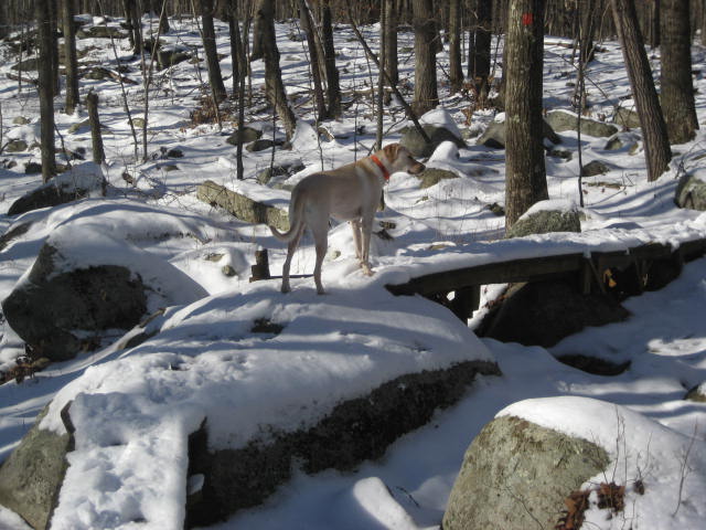
Overall, I enjoyed this trail. It is typical of the Case Mountain trails with a few "extras" thrown in for good measure. For example, in the picture below, Roscoe is crossing a wood bridge. We've crossed several of these things over the last few weeks while working our way through Bigelow Hollow State Park. I didn't see evidence of much water in the area. So, the set in the picture below seemed out of place. I imagine, since this is the lowest area of the park, that there is a lot of runoff in the spring months. I'm sure they are here for a reason.
I packed up my gear (remembering my camera this time), loaded Roscoe into the Jeep and we headed out. That's right, I was taking the Jeep this time. So, I don't need to spend too many words on parking attempts.
Those of you who remember the last time I was on these trails (Hike #28), might recall that I wasn't feeling well before that hike. So, I had to cut that hike a bit short (if you want to call 4.5 miles while recovering from the flu "short"). Anyway, my plan this time was to hit up the red trail (in the southern section of the park) and make my way back via Lookout Mountain.
I followed the same path I took on my Hike #28 out (the white trail to the blue trail). At around the 1.8 mile mark, I found the right hand turn for the red trail. Almost immediately, the trail begins to dscend. In fact, the trail descends the entire time you are on it...gradually in some spots, less gradually in others.
Overall, I enjoyed this trail. It is typical of the Case Mountain trails with a few "extras" thrown in for good measure. For example, in the picture below, Roscoe is crossing a wood bridge. We've crossed several of these things over the last few weeks while working our way through Bigelow Hollow State Park. I didn't see evidence of much water in the area. So, the set in the picture below seemed out of place. I imagine, since this is the lowest area of the park, that there is a lot of runoff in the spring months. I'm sure they are here for a reason.
From the red trail, we ran into the yellow/red trail at around the 2.5 mile mark. So, at around three quarters of a mile, the red trail isn't overly long. But it is nice.
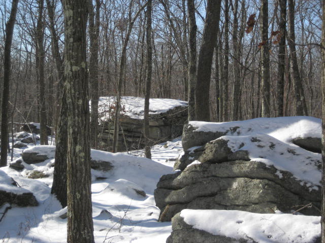
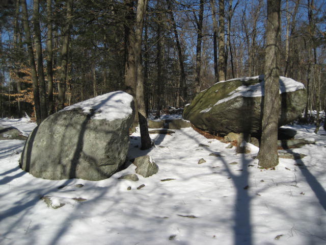
From the yellow/red trail, we connected back to the grey/white trail just as I had done on my previous hike through the area. This time, however, I had my camera. So, I got some cool shots of some of hte rock formations in the area.
From the yellow/red trail, we connected back to the grey/white trail just as I had done on my previous hike through the area. This time, however, I had my camera. So, I got some cool shots of some of hte rock formations in the area.
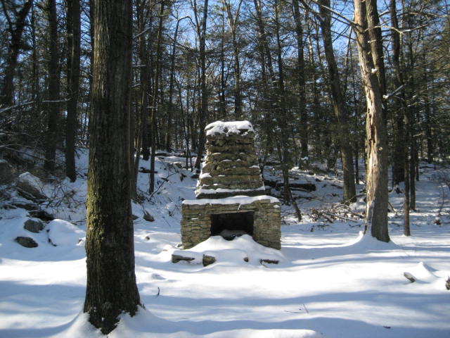
And, as promised, I also got a cool picture of the chimney I wrote about in that recap.
Eventually, I made my way from the grey/white trail and crossed the white trail to the pink trail. I was, once again, following the same path I had taken on my Hike #28. I really enjoyed this section of the hike as the excitement for the Lookout Mountain viewpoint began to build. I stopped to take the picture below. This is a vernal pool.
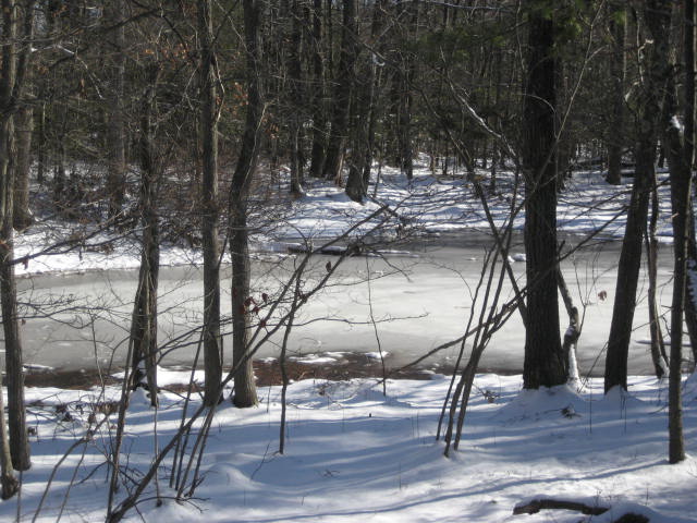
From the CFPA Walk Book: Vernal pools provide habitat that is critical to the survival of certain species of amphibians and reptiles, including frogs, toads, salamanders and turtles, that use them for mating and breeding. Certain aquatic insects and other invertebrates are also dependent upon them. I took the picture above because the first time I came through this area (in October), there wasn't much water to be found. I'll try to remember to come back and get a picture sometime this summer, when I'm certain the pool is completely empty.
From the vernal pool, we made our way a little further to the top of Lookout Mountain. I've been trying for months to get a picture of downtown Hartford, similar to the one below. But, I either forgot my camera (like on my last hike through the area) or conditions wouldn't allow for a good shot (like when I hiked up here with my dad as part of the CFPA Historical Hike). I found it ironic that I was finally able to get this shot because, on any other Friday, I would be sitting in my cubicle on the 35th floor of downtown's tallest building...wishing I was out here.
From the vernal pool, we made our way a little further to the top of Lookout Mountain. I've been trying for months to get a picture of downtown Hartford, similar to the one below. But, I either forgot my camera (like on my last hike through the area) or conditions wouldn't allow for a good shot (like when I hiked up here with my dad as part of the CFPA Historical Hike). I found it ironic that I was finally able to get this shot because, on any other Friday, I would be sitting in my cubicle on the 35th floor of downtown's tallest building...wishing I was out here.
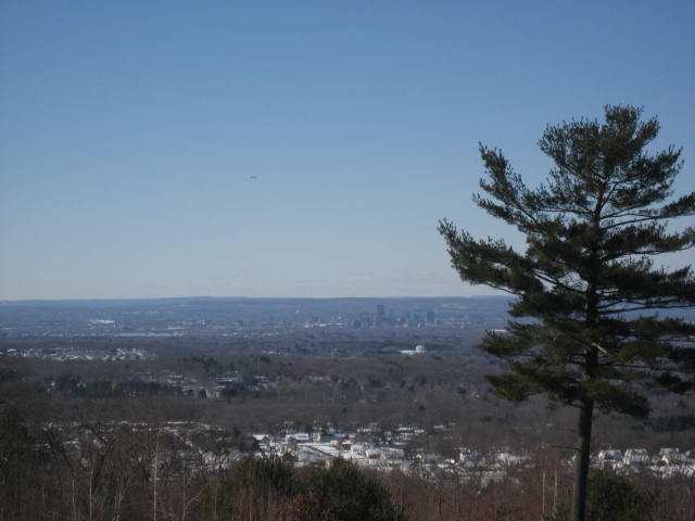
The following day, while hiking the Metacomet, I got another decent shot of downtown from the opposite direction (from the top of the ridgeline you can see in the distance of this picture).
After I took the picture, I took a minute to enjoy the other views (you can see Heublein Tower but not well enough for it to come out in a picture). From there, we hit the yellow trail back to the blue trail and then took the white trail back to the Jeep.
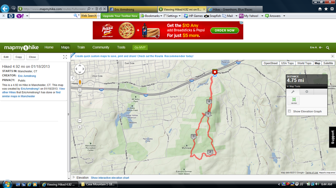
Distance Hiked: 4.92 miles
Distance to 2013 Goal: 339.75 miles
After I took the picture, I took a minute to enjoy the other views (you can see Heublein Tower but not well enough for it to come out in a picture). From there, we hit the yellow trail back to the blue trail and then took the white trail back to the Jeep.
Distance Hiked: 4.92 miles
Distance to 2013 Goal: 339.75 miles