Hike #38
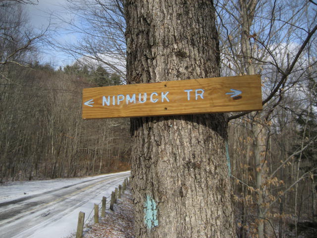
Trail: Nipmuck
Section: Warrenville Road (Mansfield, CT) to Mansfield Historical Society (Mansfield, CT)
Distance: 3.02 miles
Approx Time to Complete: 1.5 hours
Date Hiked: 2/3/2013
Date Published: 2/4/2013
Trail: Nipmuck
Section: Warrenville Road (Mansfield, CT) to Mansfield Historical Society (Mansfield, CT)
Distance: 3.02 miles
Approx Time to Complete: 1.5 hours
Date Hiked: 2/3/2013
Date Published: 2/4/2013
Super bowl Sunday! My dad and I were determined to finish up the last section of the East Branch of the Nipmuck Trail. A day earlier, we made our way from the southern terminus (off of North Windham Road) to the second iron truss bridge along the Fenton River. From the bridge, we turned on to the Fenton River Trail and made our way back to the car on Warrenville Road. So, our plan for this hike was to finish up the remaining sections north of the second bridge.
We started the day by leaving my car at the Mansfield Historical Society and parked my dad’s truck at the baseball fields near Southeast School on Warrenville Road. This meant that the early sections of our hike would cover trail we had just covered the day before (and a later section would cover trail we hiked a week earlier), but that was okay by us because we were eager to finish up these sections by any means necessary.
Before setting out, I thought this would make for a good“follow-up” hike to the last one. I was expecting that this hike, at just over three miles, would be easy going when compared to the almost seven miles we did the day before. But, what this hike lacks in distance, it more than makes up for in difficulty. And that was a complete surprise to me.
Once we parked my dad’s truck, we crossed Warrenville Road and entered the woods on the north side of the road. I forgot to transfer Roscoe’s leash from my car to the truck when I moved all of my the other gear. So, the road crossing here was slightly more difficult than it needed to be. Fortunately, there was only one other road crossing on this hike…and it wasn’t a busy road.
As we made our way around the area of the levee/spillway which I wrote about in my last hike, we saw another pair of hikers joining the Nipmuck from an access trail. We decided to slow our pace so we weren’t all bunched together. However, they were moving very slow. Earlier, we were discussing if we should take the Nipmuck the whole way or follow the Fenton River Trail. Once we saw how slowly these two were moving, we decided to take whichever path they didn’t…and then try to outpace them to where the trails intersect again. They elected to stay on the Nipmuck Trail so we took the Fenton River Trail. This wasn’t our first choice, as we were hoping to examine the deer carcass on The Nipmuck more closely. But, fate decided we should travel the Fenton River Trail again…so we did.
The Fenton River Trail didn’t change much in the 24 hours since we last travelled it. But, we were hiking in the opposite direction this time so that was a nice change of pace. I found it funny that Roscoe seemed to be heading “off-trail” in the same locations as the day before. I guess he was tracking himself. I don’t know. If he was, I’m not certain he knew that he was following himself. Maybe I don’t give him enough credit, but I doubt those are super awesome doggy sections that only our four legged friends can enjoy. I think he was just thinking“Oh, I smell another dog!” without realizing that he was the other dog.
Shortly before the second intersection, we were able to see across the river and noticed the other hikers were keeping pace. In all honesty, I think the trail on that side of the river is shorter. I know for a fact is it less hilly and curvy. Either way, we picked up the pace and passed the intersection of the two trails before they got there.
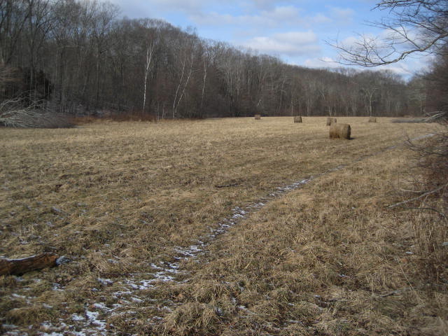
Just north of the trail intersection (now entering new territory for us), the trail sticks to the edge of the river as it also follows along this large field…
We started the day by leaving my car at the Mansfield Historical Society and parked my dad’s truck at the baseball fields near Southeast School on Warrenville Road. This meant that the early sections of our hike would cover trail we had just covered the day before (and a later section would cover trail we hiked a week earlier), but that was okay by us because we were eager to finish up these sections by any means necessary.
Before setting out, I thought this would make for a good“follow-up” hike to the last one. I was expecting that this hike, at just over three miles, would be easy going when compared to the almost seven miles we did the day before. But, what this hike lacks in distance, it more than makes up for in difficulty. And that was a complete surprise to me.
Once we parked my dad’s truck, we crossed Warrenville Road and entered the woods on the north side of the road. I forgot to transfer Roscoe’s leash from my car to the truck when I moved all of my the other gear. So, the road crossing here was slightly more difficult than it needed to be. Fortunately, there was only one other road crossing on this hike…and it wasn’t a busy road.
As we made our way around the area of the levee/spillway which I wrote about in my last hike, we saw another pair of hikers joining the Nipmuck from an access trail. We decided to slow our pace so we weren’t all bunched together. However, they were moving very slow. Earlier, we were discussing if we should take the Nipmuck the whole way or follow the Fenton River Trail. Once we saw how slowly these two were moving, we decided to take whichever path they didn’t…and then try to outpace them to where the trails intersect again. They elected to stay on the Nipmuck Trail so we took the Fenton River Trail. This wasn’t our first choice, as we were hoping to examine the deer carcass on The Nipmuck more closely. But, fate decided we should travel the Fenton River Trail again…so we did.
The Fenton River Trail didn’t change much in the 24 hours since we last travelled it. But, we were hiking in the opposite direction this time so that was a nice change of pace. I found it funny that Roscoe seemed to be heading “off-trail” in the same locations as the day before. I guess he was tracking himself. I don’t know. If he was, I’m not certain he knew that he was following himself. Maybe I don’t give him enough credit, but I doubt those are super awesome doggy sections that only our four legged friends can enjoy. I think he was just thinking“Oh, I smell another dog!” without realizing that he was the other dog.
Shortly before the second intersection, we were able to see across the river and noticed the other hikers were keeping pace. In all honesty, I think the trail on that side of the river is shorter. I know for a fact is it less hilly and curvy. Either way, we picked up the pace and passed the intersection of the two trails before they got there.
Just north of the trail intersection (now entering new territory for us), the trail sticks to the edge of the river as it also follows along this large field…
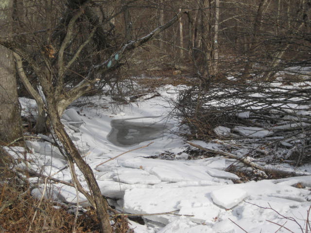
The proximity to the edge of the river became a problem for us when we reached a section where the trail was previously washed out. The water must have retreated under the ice back to where the river normally flows. And, it must have done so in a way that the water on top stayed frozen. I initially tried to walk over this ice but it didn’t take long before I broke through…
This water/ice development along the edge of the river forced us to head into the field and follow along a path through there for a stretch. At the northwest corner of the field, the path turned into a woods road. However, it wasn’t long before we were able to, with some minor bushwhacking, cut back over to the true trail. We were only back on the trail for a minute when it made a sharp left turn, crossed the woods road we were just on, and started to climb as it approached Chafeeville Road.
Over the next mile and a half, including the road crossing, we climbed about 400 feet in elevation. I didn’t think this was overly challenging but my dad added a degree of difficulty by carrying on a cell phone conversation for a good portion of it. Normally, I would frown upon cell phone use in the middle of the woods for an extended period of time. But, he and my mom were hosting a Super Bowl party. So, he was trying to coordinate last minute items. And, I’ll give him a pass for that. Hopefully he laughs when he reads this.
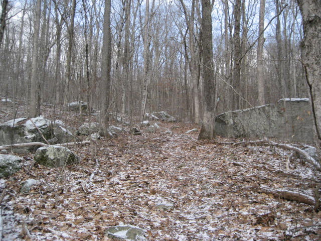
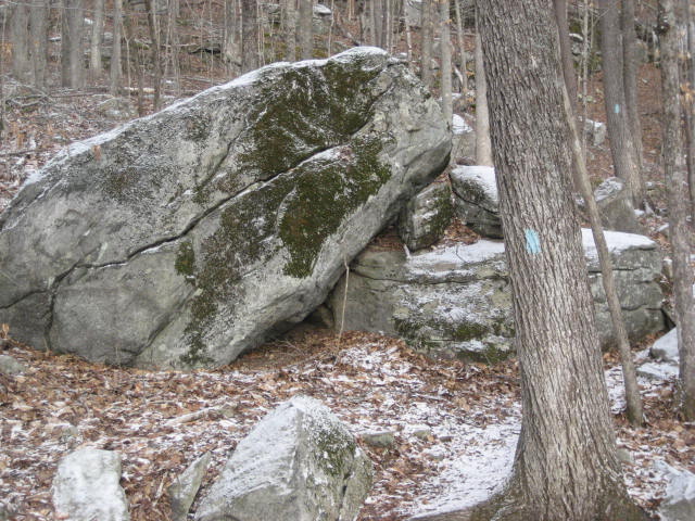
As we made our way up to the area of 50 Foot Rock, I took this picture of a portion of the ascent…
Over the next mile and a half, including the road crossing, we climbed about 400 feet in elevation. I didn’t think this was overly challenging but my dad added a degree of difficulty by carrying on a cell phone conversation for a good portion of it. Normally, I would frown upon cell phone use in the middle of the woods for an extended period of time. But, he and my mom were hosting a Super Bowl party. So, he was trying to coordinate last minute items. And, I’ll give him a pass for that. Hopefully he laughs when he reads this.
As we made our way up to the area of 50 Foot Rock, I took this picture of a portion of the ascent…
I also stopped to snap this picture as we were about to cross a stream…
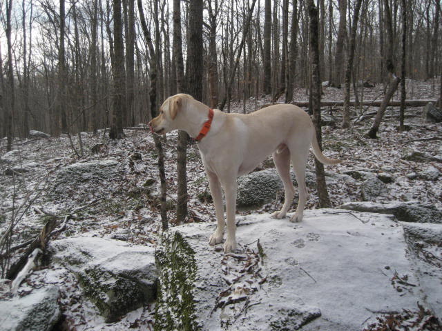
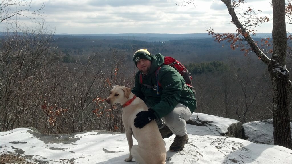
And, I took a picture of Roscoe doing his thing…
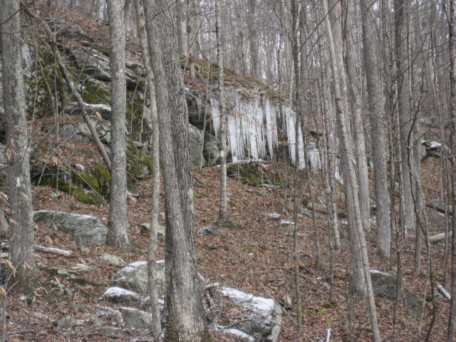
Finally, I took this picture of a cool icicle formation…
For the record…yes, I was TOTALLY stalling by taking this many pictures along the ascent. But, this was also the only real highlight we had for this day. So, even though I stalled because I was tired, I was also trying to get some good shots to post in this recap. Call me a chumpfor stalling next time you see me, if you must, but this climb was really no joke. MapMyHike had it as a category 4 climb. And, that puts it on par with the ascent to Castle Craig (over on The Metacomet)…which I think is pretty impressive. I find it even more impressive considering I thought this hike would be a “cruise-control” hike.
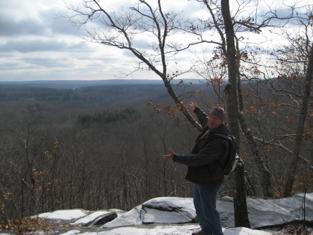
As it turns out, all that climbing was…as it usually is…well worth it. The views from 50 Foot Rock are amazing. We spent some time here enjoying the sights, catching our breath, and trying to figure out if we could see the area where we left my dad’s truck. The views up here are truly spectacular and, while I expected them to be good, they surpassed my expectations. It really was a treat.
As it turns out, all that climbing was…as it usually is…well worth it. The views from 50 Foot Rock are amazing. We spent some time here enjoying the sights, catching our breath, and trying to figure out if we could see the area where we left my dad’s truck. The views up here are truly spectacular and, while I expected them to be good, they surpassed my expectations. It really was a treat.
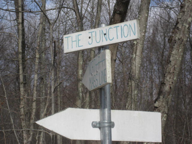
From the area of 50 Foot Rock, the trail heads west and we followed along until we came to the North/South Junction…
I was surprised at how close 50 Foot Rock is to the junction. A week earlier, we passed through this are while making our way north from the Mansfield Historical Society. And I didn’t realize at the time how close we were to the views. Otherwise, I would have demanded a quick detour from that hike.
The portions of the Nipmuck trail directly in front of us would eventually lead us north to Rt. 44 and, beyond that, to Massachusetts. But, we had already traveled a good portion of that trail last week. So, we made a left and followed the West Branch in a southwesterly direction back to my car.
This was a great hike. My legs were tired from the hike the day before. My arms and chest were sore from working out the night before. And, this hike was a lot more challenging that I thought it would be. But, we soldiered on and we’ve now completed both the West and East Branches.
Next up on our Nipmuck adventures is the section from Rt. 44 to Rt. 74. Among other things, that section will allow us to finally experience the trail outside of Mansfield. Not that Mansfield has been bad (quite the opposite), but the last four hikes (20+ miles) have been entirely in the same town. And, I’m ready for a change. The CFPA Walk Book says that the terrain on the next section is “generally easy going”. But, I thought the terrain on this hike would be “easy going” and it wasn’t. So, I guess we’ll just have to see when we get there…
Distance to goal: 298.19
