Hike #4
Vin Gormley Trail (Charlestown, RI)
Distance: Completed 4.81 miles of the 8.1 mile loop
Date Hiked: 7/7/2012
Date Published: 12/20/2012
Hiking in July sucks. I just wanted to get that out of the way. It is brutally hot and humid, you never know when you might get caught in the middle of a storm, and the ticks (which thrive at around a temperature of 50 degrees) have been replaced by mosquitoes and biting flies. Good times!
In my last write-up, I talked about how I took a break from hiking. After I posted it, I realized that wasn’t entirely truthful. There were, in fact, a couple of hike-like experiences in between “tick day” and this July hike, but they weren’t anything special.
Basically, these “hikes” included JB Williams Park in Glastonbury, CT (which you can read more about at http://www.glasct.org/index.aspx?page=205)…but that’s more like hiking with training wheels. There is a section there where you will find an old, abandoned ski-lift…which is cool. In fact, I’m sure people pass by there every day without knowing that you used to be able to ski up that way. So, I guess there is some stuff to see here but it isn’t anything like the hiking I’d previously done on The Metacomet.
There were also a couple of treks on the Bike Trail in Manchester, CT (which is part of the East Coast Greenway...you can read more about it at http://www.traillink.com/trail/charter-oak-greenway.aspx). Roscoe and I even walked from one end of the trail (out by Highland Park Market) through the Charter Oak Park section all the way back to the house (we live close to Crossroad Community Cathedral on the East Hartford / Manchester town line). We also covered the area in and around Wickham Park. And, at one point, made the walk up to Veteran’s Memorial Clubhouse (on Sunset Ridge in East Hartford) and back our regular evening walk. But, all of that Bike Trail walking is basically just walking with a few hills thrown in for good measure.
Even though I had sworn off actual hiking only a few months before, I was eager to get back to it.
The weekend after the Fourth of July, we had made plans to head down (over) to Burlingame State Park & Campground in Charlestown, RI with my parents and some of their friends. We were excited. Not only because this would be the first time we had been camping in a couple of years, but because this would be the first time camping with Roscoe. And, for all you non-dog people out there, I have to say that nothing beats any first-time experience with your dog. There is just something about that “unknown” factor and watching them surprise you by reacting in the exact opposite way you expected.
My parents had gone down a day or two earlier and were planning to stay the whole weekend. But, since we weren’t sure how it would go with Roscoe, we planned on only staying one night. So, we got up early on Saturday and made the hour or so drive. We set up the tent and then went down to the pond. It was time to prove, once and for all, that Roscoe was capable of swimming.
I was concerned because the research I had done ahead of time said that dogs weren’t allowed in the swimming area and that swimming outside of the designated areas was not recommended. I have to give credit to my dad here. He was very adamant that everything would be okay…and it was.
When we got to the pond, there was a group of people and one other dog already swimming in the area outside of the “designated” swimming area. That put my mind at ease, especially since nobody seemed to be giving them a hard time about it. So, we took off our shirts, hit some of our best “which way to the beach?” poses and went in. And, of course, Roscoe followed right behind. For a lab, he isn’t the best swimmer in the world…but, he hurt his leg a few days after we originally got him so we give him a pass. From what I could tell, he loved it…even if he would only go swimming one other time since that day (a few days later when we made a trip to Block Island).
Once we were done at the pond, everyone else was content to hang out by the fire until chow time…but I had already made up my mind about hiking the Vin Gromley Trail.
The trail is basically one big loop that circles the pond (Watchaug Pond) and they even give out maps right at the camp store. So, if you didn’t plan ahead, fear not. One section of the trail even has a covered walking bridge. But, as you will read, we never made it that far.
The elevation doesn’t change all that much so this isn’t a difficult trail by any stretch. There are a few rocky sections around mile number 4 (up near the northwest corner of the trail, where the trail interescts with Rhode Island's North/South Trail) but those sections aren't anything you can’t handle. The only problem you might have is if you are like me, and you decide to hike this trail on what I’m pretty sure was the hottest day of the year. Adding to the challenge was the fact that it started to rain. Normally, you would think the rain would help cool us off. Nope. All it did was increase the bug activity.
I don’t want anyone to think I’m a big complainer, because I’m really not. I usually just put my head down and keep trucking along. I’m really just stating facts. And, the fact is, I picked a really bad day to try and make this hike.
The first two miles of the trail were really nice, even if half of it is just a glorified road walk. It starts by skirting along the pond, passing by a few of the public beach areas on the other side from where we were swimming earlier. It also passes a Cub / Boy Scout camp. We stopped not too far from there so I could chat with one of the locals and Roscoe could sniff around. I probably should have been more concerned when the local asked me, in a shocked tone “are you going to do the whole 8.1 miles today?” From there, it was all downhill…and not in the nice downhill sense where you can pick up your pace slightly to finish with a better time than you previously anticipated. Downhill in the metaphorical sense...as in "This is about to get ugly..."
When I tell you that I was being hunted by the most relentless biting fly ever, I literally mean that I was being hunted by the most relentless biting fly ever. So much for that bug spray I applied and re-applied. Fortunately, I was able to feel him land on me so he wasn’t able to bite me too much (although he did get me a few times). Unfortunately, I was flailing my arms around so much (which I’m sure looked hilarious to those not involved in the situation) that 4.81 miles felt like 48.1 miles. I hiked 10 miles about a week before publishing this recap and I was less tired after I was done with that hike than on this 4.81 mile journey. I was pretty much exhausted.
Complicating matters even further is the fact that Roscoe kept stopping every three minutes. Not to stop and sniff, or pee, or poo. Just...stopping. I thought maybe he was just thirsty. But, every time I offered him a drink, he refused. So, it became this game of taking out his bowl, pouring some water for him, pouring it out after he refused to drink it, and then re-packing everything. Again, all while I tried my best to deter the most determined biting fly ON THE PLANET!
Finally, I had enough…so, when I got to the closest road (a section of the trail at about the halfway point requires you to do a road walk), I called Jaci. I knew what road I was on and that I was heading south (I had even recently downloaded an app called MapMyHike which allowed me to track hike distances and times in real-time) so I was able to relay that information to her. Eventually, after walking down the road about a half mile, I found a house with the number on the mailbox and asked her to put it into the GPS on her phone (naturally, as soon as I hung up with her, the fly was nowhere to be found). She found us and single-handedly saved the day. Have I mentioned before how much I love her?
My first hike in a while and I had to be “medevacced” out. Grrrrrrrrrrreat…
In all seriousness, I refuse to look at this is a failure. Rather than just sitting around the camp fire drinking soda and adding calories to my body, I burned 1700 calories by hiking 4.81 miles in 90-degree weather with a dog who quit on me after 3 miles and a biting fly who was hell-bent on having my blood. All in all, not bad. And, I will return to complete the hike next time we are in the area. That shouldn’t be too long from now because it is a beautiful campground and we love camping there. May sounds like a nice time to try again…maybe Memorial Day Weekend. Who knows?
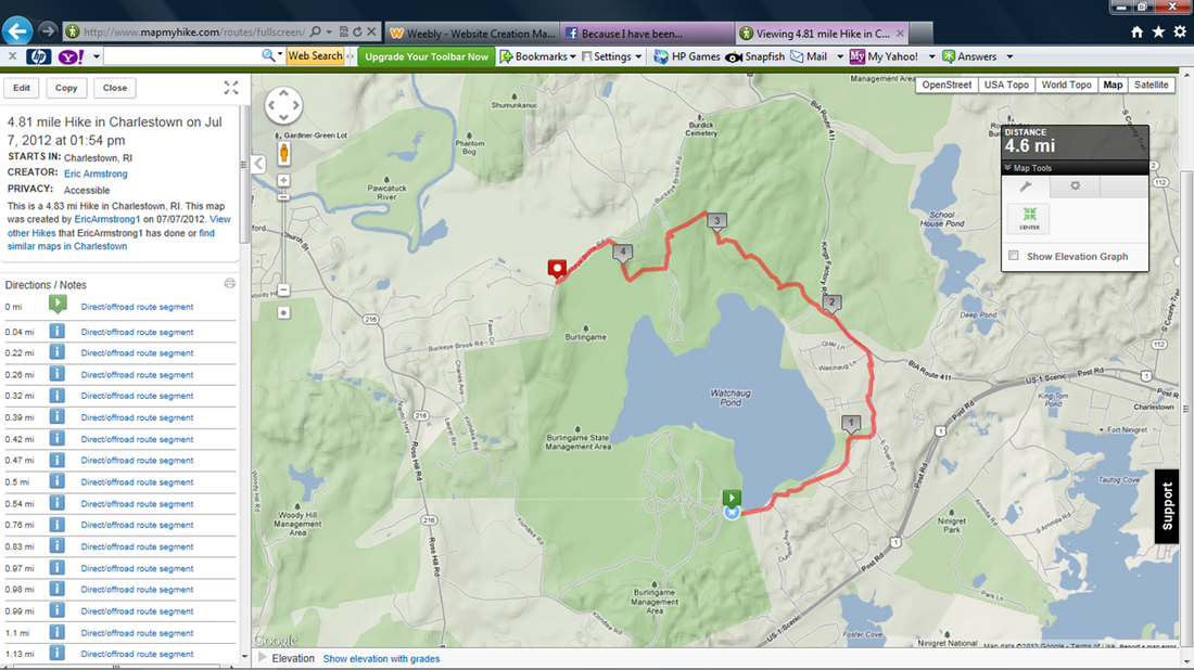
Before I close out this recap, I want to take a few lines to write about the MapMyHike app. When I downloaded it, it was free. If it still is, I suggest you pick it up. While the purists might argue that this takes away from the true “return to wilderness” of hiking, I say it is a cool way to keep track of how far you’ve gone and how long it took you to get there. It also has a cool feature where it shows you elevation changes (a fun pastime of mine is looking to see how many category 5 climbs I did on each hike). It even keeps a record, so you can go back and compare your past hikes to the hike you just completed. In a way, this allows you to track your improvement. For example, on this hike I walked 4.81 miles in just over 2 hours (an average pace of 25:48 minutes per mile). On one of my recent hikes, I walked 8.35 miles in 3 hours and 20 minutes (an average pace of 23:59 minutes per mile). And, the most recent hike was over a lot tougher terrain. So, you can see how much I’ve improved in five months. For me, that is the ultimate motivation…it forces me to keep pushing myself. Below is a copy of one of the MapMyHike maps which you can access when you're done. The app also provides a picture to your phone or iPad once you're done, which you can share with your friends on Facebook and Twitter. Many of you who have been tracking my progress have seen a similar map, which I post to my Facebook page after each hike. The purists can say what they want; I think it is just the coolest thing to go back later and look at this when I’m safe at home, resting on the couch.
Vin Gormley Trail (Charlestown, RI)
Distance: Completed 4.81 miles of the 8.1 mile loop
Date Hiked: 7/7/2012
Date Published: 12/20/2012
Hiking in July sucks. I just wanted to get that out of the way. It is brutally hot and humid, you never know when you might get caught in the middle of a storm, and the ticks (which thrive at around a temperature of 50 degrees) have been replaced by mosquitoes and biting flies. Good times!
In my last write-up, I talked about how I took a break from hiking. After I posted it, I realized that wasn’t entirely truthful. There were, in fact, a couple of hike-like experiences in between “tick day” and this July hike, but they weren’t anything special.
Basically, these “hikes” included JB Williams Park in Glastonbury, CT (which you can read more about at http://www.glasct.org/index.aspx?page=205)…but that’s more like hiking with training wheels. There is a section there where you will find an old, abandoned ski-lift…which is cool. In fact, I’m sure people pass by there every day without knowing that you used to be able to ski up that way. So, I guess there is some stuff to see here but it isn’t anything like the hiking I’d previously done on The Metacomet.
There were also a couple of treks on the Bike Trail in Manchester, CT (which is part of the East Coast Greenway...you can read more about it at http://www.traillink.com/trail/charter-oak-greenway.aspx). Roscoe and I even walked from one end of the trail (out by Highland Park Market) through the Charter Oak Park section all the way back to the house (we live close to Crossroad Community Cathedral on the East Hartford / Manchester town line). We also covered the area in and around Wickham Park. And, at one point, made the walk up to Veteran’s Memorial Clubhouse (on Sunset Ridge in East Hartford) and back our regular evening walk. But, all of that Bike Trail walking is basically just walking with a few hills thrown in for good measure.
Even though I had sworn off actual hiking only a few months before, I was eager to get back to it.
The weekend after the Fourth of July, we had made plans to head down (over) to Burlingame State Park & Campground in Charlestown, RI with my parents and some of their friends. We were excited. Not only because this would be the first time we had been camping in a couple of years, but because this would be the first time camping with Roscoe. And, for all you non-dog people out there, I have to say that nothing beats any first-time experience with your dog. There is just something about that “unknown” factor and watching them surprise you by reacting in the exact opposite way you expected.
My parents had gone down a day or two earlier and were planning to stay the whole weekend. But, since we weren’t sure how it would go with Roscoe, we planned on only staying one night. So, we got up early on Saturday and made the hour or so drive. We set up the tent and then went down to the pond. It was time to prove, once and for all, that Roscoe was capable of swimming.
I was concerned because the research I had done ahead of time said that dogs weren’t allowed in the swimming area and that swimming outside of the designated areas was not recommended. I have to give credit to my dad here. He was very adamant that everything would be okay…and it was.
When we got to the pond, there was a group of people and one other dog already swimming in the area outside of the “designated” swimming area. That put my mind at ease, especially since nobody seemed to be giving them a hard time about it. So, we took off our shirts, hit some of our best “which way to the beach?” poses and went in. And, of course, Roscoe followed right behind. For a lab, he isn’t the best swimmer in the world…but, he hurt his leg a few days after we originally got him so we give him a pass. From what I could tell, he loved it…even if he would only go swimming one other time since that day (a few days later when we made a trip to Block Island).
Once we were done at the pond, everyone else was content to hang out by the fire until chow time…but I had already made up my mind about hiking the Vin Gromley Trail.
The trail is basically one big loop that circles the pond (Watchaug Pond) and they even give out maps right at the camp store. So, if you didn’t plan ahead, fear not. One section of the trail even has a covered walking bridge. But, as you will read, we never made it that far.
The elevation doesn’t change all that much so this isn’t a difficult trail by any stretch. There are a few rocky sections around mile number 4 (up near the northwest corner of the trail, where the trail interescts with Rhode Island's North/South Trail) but those sections aren't anything you can’t handle. The only problem you might have is if you are like me, and you decide to hike this trail on what I’m pretty sure was the hottest day of the year. Adding to the challenge was the fact that it started to rain. Normally, you would think the rain would help cool us off. Nope. All it did was increase the bug activity.
I don’t want anyone to think I’m a big complainer, because I’m really not. I usually just put my head down and keep trucking along. I’m really just stating facts. And, the fact is, I picked a really bad day to try and make this hike.
The first two miles of the trail were really nice, even if half of it is just a glorified road walk. It starts by skirting along the pond, passing by a few of the public beach areas on the other side from where we were swimming earlier. It also passes a Cub / Boy Scout camp. We stopped not too far from there so I could chat with one of the locals and Roscoe could sniff around. I probably should have been more concerned when the local asked me, in a shocked tone “are you going to do the whole 8.1 miles today?” From there, it was all downhill…and not in the nice downhill sense where you can pick up your pace slightly to finish with a better time than you previously anticipated. Downhill in the metaphorical sense...as in "This is about to get ugly..."
When I tell you that I was being hunted by the most relentless biting fly ever, I literally mean that I was being hunted by the most relentless biting fly ever. So much for that bug spray I applied and re-applied. Fortunately, I was able to feel him land on me so he wasn’t able to bite me too much (although he did get me a few times). Unfortunately, I was flailing my arms around so much (which I’m sure looked hilarious to those not involved in the situation) that 4.81 miles felt like 48.1 miles. I hiked 10 miles about a week before publishing this recap and I was less tired after I was done with that hike than on this 4.81 mile journey. I was pretty much exhausted.
Complicating matters even further is the fact that Roscoe kept stopping every three minutes. Not to stop and sniff, or pee, or poo. Just...stopping. I thought maybe he was just thirsty. But, every time I offered him a drink, he refused. So, it became this game of taking out his bowl, pouring some water for him, pouring it out after he refused to drink it, and then re-packing everything. Again, all while I tried my best to deter the most determined biting fly ON THE PLANET!
Finally, I had enough…so, when I got to the closest road (a section of the trail at about the halfway point requires you to do a road walk), I called Jaci. I knew what road I was on and that I was heading south (I had even recently downloaded an app called MapMyHike which allowed me to track hike distances and times in real-time) so I was able to relay that information to her. Eventually, after walking down the road about a half mile, I found a house with the number on the mailbox and asked her to put it into the GPS on her phone (naturally, as soon as I hung up with her, the fly was nowhere to be found). She found us and single-handedly saved the day. Have I mentioned before how much I love her?
My first hike in a while and I had to be “medevacced” out. Grrrrrrrrrrreat…
In all seriousness, I refuse to look at this is a failure. Rather than just sitting around the camp fire drinking soda and adding calories to my body, I burned 1700 calories by hiking 4.81 miles in 90-degree weather with a dog who quit on me after 3 miles and a biting fly who was hell-bent on having my blood. All in all, not bad. And, I will return to complete the hike next time we are in the area. That shouldn’t be too long from now because it is a beautiful campground and we love camping there. May sounds like a nice time to try again…maybe Memorial Day Weekend. Who knows?
Before I close out this recap, I want to take a few lines to write about the MapMyHike app. When I downloaded it, it was free. If it still is, I suggest you pick it up. While the purists might argue that this takes away from the true “return to wilderness” of hiking, I say it is a cool way to keep track of how far you’ve gone and how long it took you to get there. It also has a cool feature where it shows you elevation changes (a fun pastime of mine is looking to see how many category 5 climbs I did on each hike). It even keeps a record, so you can go back and compare your past hikes to the hike you just completed. In a way, this allows you to track your improvement. For example, on this hike I walked 4.81 miles in just over 2 hours (an average pace of 25:48 minutes per mile). On one of my recent hikes, I walked 8.35 miles in 3 hours and 20 minutes (an average pace of 23:59 minutes per mile). And, the most recent hike was over a lot tougher terrain. So, you can see how much I’ve improved in five months. For me, that is the ultimate motivation…it forces me to keep pushing myself. Below is a copy of one of the MapMyHike maps which you can access when you're done. The app also provides a picture to your phone or iPad once you're done, which you can share with your friends on Facebook and Twitter. Many of you who have been tracking my progress have seen a similar map, which I post to my Facebook page after each hike. The purists can say what they want; I think it is just the coolest thing to go back later and look at this when I’m safe at home, resting on the couch.