Hike #5
Trail: Metacomet (Including the Heublein Tower Trail and the Alternate Trail near Reservoir #6)
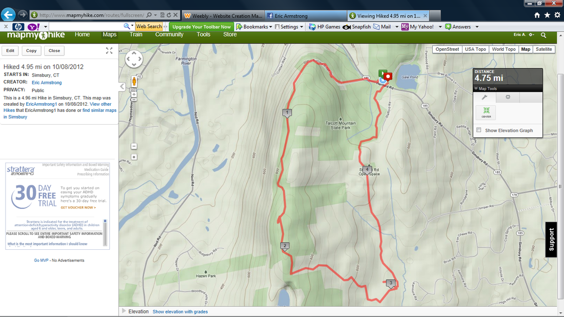
Distance: 4.95 mile loop
Approximate time to complete: 2 hours
Date Hiked: 10/8/2012
Date Published: 12/22/2012
Trail: Metacomet (Including the Heublein Tower Trail and the Alternate Trail near Reservoir #6)
Distance: 4.95 mile loop
Approximate time to complete: 2 hours
Date Hiked: 10/8/2012
Date Published: 12/22/2012
Columbus Day. I was eager to get back to real hiking. Sadly, Roscoe was still feeling a little under the weather so this would be a solo trip.
Once I decided I wanted to get back into hiking and use it as a way to keep weight off through the winter months, I decided to start by heading back up to Heublein Tower. I mentioned in previous posts how I had been up there several times before. But, now that I was attempting to become a member of the CT400, I wanted to make sure I covered this section of the Metacomet by sticking exactly to the trail. Later, I decided that this hike should become an annual Columbus Day event. So, I ended up NOT sticking exactly to the trail…thinking that I would have plenty of chances to hit up the Metacomet proper. So, I outlined a trail that would allow me to experience the best views.
I’m always intrigued by the traffic, of lack thereof, on these holidays. Normally, driving from our house to the trail would require I go way out of my way and take a different route to avoid downtown Hartford. But, since only a handful of people (like my wife) work on these holidays; I’m able to drive right through downtown in a quarter of the time it would normally take during a Monday morning rush hour.
In the interest of keeping this hike fresh, I decided to park in the lot on the other side of Rt. 185 in Penwood State Park. I knew this would add a little extra mileage (mostly road walk) but I also knew that, by the time I finished hiking, the lot on the other side of 185 (the Tower side) would be packed. I knew this because I had previously taken Roscoe up to the tower on Columbus Day the year before…and, after our hike, it was a mad house trying to get out of the lot. I guess I could have used that hike…back in October of 2011…as my Hike #1 recap, but it was an uneventful trip (the hike I did recap, with Jaci and I hiking through Plainville, was much more exciting).
From the Tower Trail lot, there are two ways to get up to the tower. You can either a.) follow the trail that starts in the “middle” of the lot or b.) follow the road (Summit Ridge Drive) up to the cul-de-sac (the one where Lifestar lands in emergency situations) and take the more challenging trail which sticks more closely to the ridgeline. Option B is a lot more challenging (not overly challenging as I’ve seen little kids make the trip), but it also affords about three additional viewpoints. And, since it is off the “beaten path”, odds are you’ll have these viewpoints all to yourself. If you are concerned about how challenging it is, the viewpoints also allow for a few “rest areas” along the way. Then again, there will be plenty of other chances to check out the views later. So, if you are unsure, stick to the trail that starts in the middle of the lot.
Once you finish your ascent, no matter which way you choose, the trails will meet up for the rest of the hike up to the tower. Once you are on top of the ridge, the trail levels off and it is pretty flat for the remainder of the way. Just before you reach the tower, there is a spot…off the trail…with a cliff. It is not uncommon to see people trying to climb the cliff. You don't have to scale the wall to complete the hike, so I wouldn’t recommend it. But, I’m not here to tell you what to do.
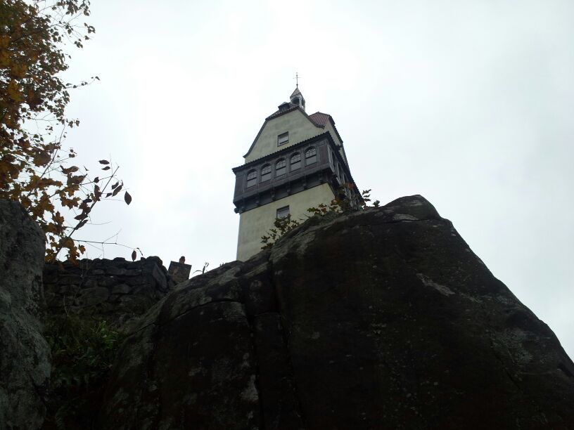
Once you reach the tower, you can hang out in the picnic area and cool off / rehydrate before you go inside the tower. The tower is only open on certain days. So, if you are only interested in going inside, make sure you check out their website to confirm the hours they are open before you go.
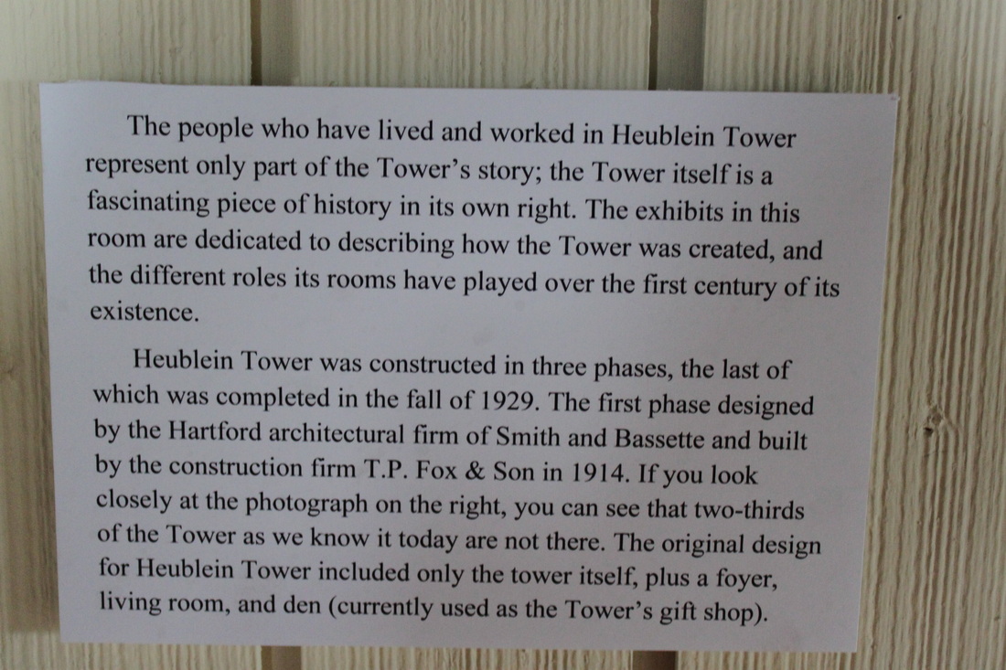
The tower, which was originally constructed in 1914, has played host to all kinds of neat events and famous people. According to http://www.friendsofheubleintower.org/ the tower was the site where the Republican Party asked Eisenhower to run for president. Pretty cool stuff.
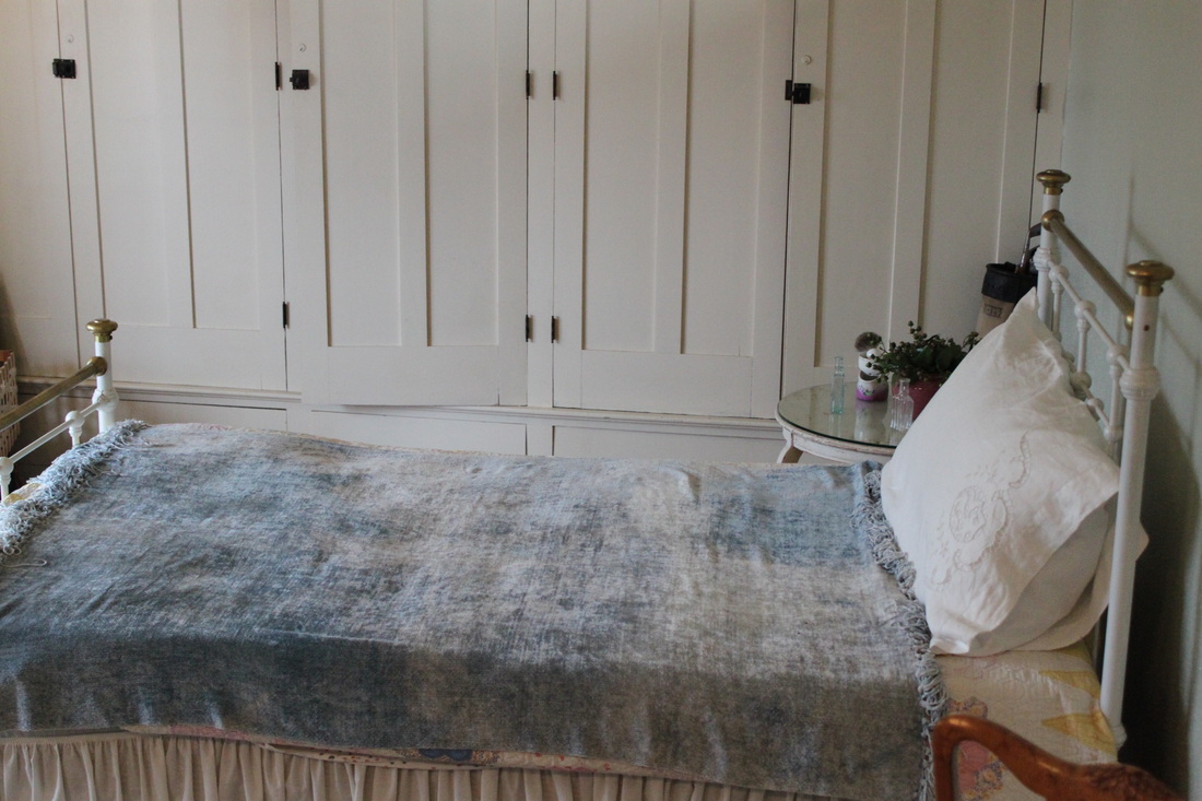
I’ve been up to the tower countless times, but it was never open so I’d never been inside. Today, I was in luck...they were open. So, I went inside and took the pictures you see below. I stopped at the top level to chat with a kind gentleman about how well my beloved Baltimore Orioles were playing this year. Being able to talk baseball the second week of October was pretty sweet. Once we were done, I poked around the tower a bit more and went back downstairs to hit the trail again.
Once I decided I wanted to get back into hiking and use it as a way to keep weight off through the winter months, I decided to start by heading back up to Heublein Tower. I mentioned in previous posts how I had been up there several times before. But, now that I was attempting to become a member of the CT400, I wanted to make sure I covered this section of the Metacomet by sticking exactly to the trail. Later, I decided that this hike should become an annual Columbus Day event. So, I ended up NOT sticking exactly to the trail…thinking that I would have plenty of chances to hit up the Metacomet proper. So, I outlined a trail that would allow me to experience the best views.
I’m always intrigued by the traffic, of lack thereof, on these holidays. Normally, driving from our house to the trail would require I go way out of my way and take a different route to avoid downtown Hartford. But, since only a handful of people (like my wife) work on these holidays; I’m able to drive right through downtown in a quarter of the time it would normally take during a Monday morning rush hour.
In the interest of keeping this hike fresh, I decided to park in the lot on the other side of Rt. 185 in Penwood State Park. I knew this would add a little extra mileage (mostly road walk) but I also knew that, by the time I finished hiking, the lot on the other side of 185 (the Tower side) would be packed. I knew this because I had previously taken Roscoe up to the tower on Columbus Day the year before…and, after our hike, it was a mad house trying to get out of the lot. I guess I could have used that hike…back in October of 2011…as my Hike #1 recap, but it was an uneventful trip (the hike I did recap, with Jaci and I hiking through Plainville, was much more exciting).
From the Tower Trail lot, there are two ways to get up to the tower. You can either a.) follow the trail that starts in the “middle” of the lot or b.) follow the road (Summit Ridge Drive) up to the cul-de-sac (the one where Lifestar lands in emergency situations) and take the more challenging trail which sticks more closely to the ridgeline. Option B is a lot more challenging (not overly challenging as I’ve seen little kids make the trip), but it also affords about three additional viewpoints. And, since it is off the “beaten path”, odds are you’ll have these viewpoints all to yourself. If you are concerned about how challenging it is, the viewpoints also allow for a few “rest areas” along the way. Then again, there will be plenty of other chances to check out the views later. So, if you are unsure, stick to the trail that starts in the middle of the lot.
Once you finish your ascent, no matter which way you choose, the trails will meet up for the rest of the hike up to the tower. Once you are on top of the ridge, the trail levels off and it is pretty flat for the remainder of the way. Just before you reach the tower, there is a spot…off the trail…with a cliff. It is not uncommon to see people trying to climb the cliff. You don't have to scale the wall to complete the hike, so I wouldn’t recommend it. But, I’m not here to tell you what to do.
Once you reach the tower, you can hang out in the picnic area and cool off / rehydrate before you go inside the tower. The tower is only open on certain days. So, if you are only interested in going inside, make sure you check out their website to confirm the hours they are open before you go.
The tower, which was originally constructed in 1914, has played host to all kinds of neat events and famous people. According to http://www.friendsofheubleintower.org/ the tower was the site where the Republican Party asked Eisenhower to run for president. Pretty cool stuff.
I’ve been up to the tower countless times, but it was never open so I’d never been inside. Today, I was in luck...they were open. So, I went inside and took the pictures you see below. I stopped at the top level to chat with a kind gentleman about how well my beloved Baltimore Orioles were playing this year. Being able to talk baseball the second week of October was pretty sweet. Once we were done, I poked around the tower a bit more and went back downstairs to hit the trail again.
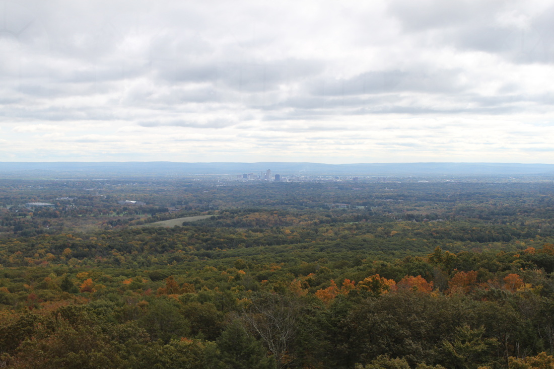
Downtown Hartford
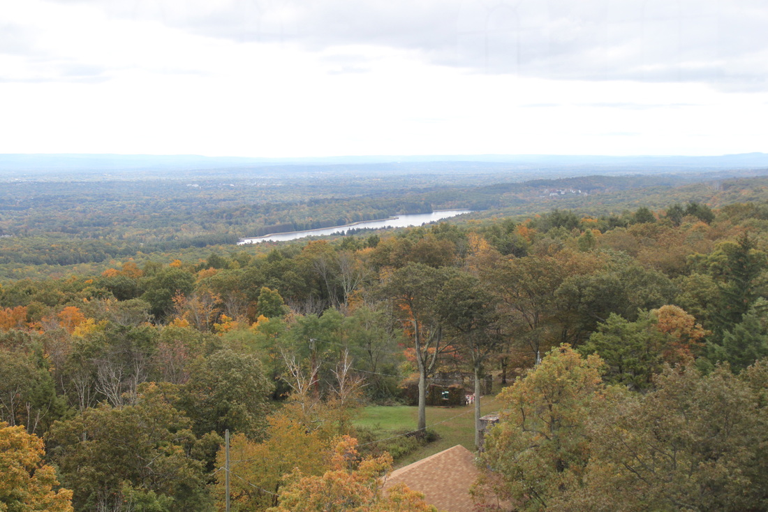
Reservoir #6
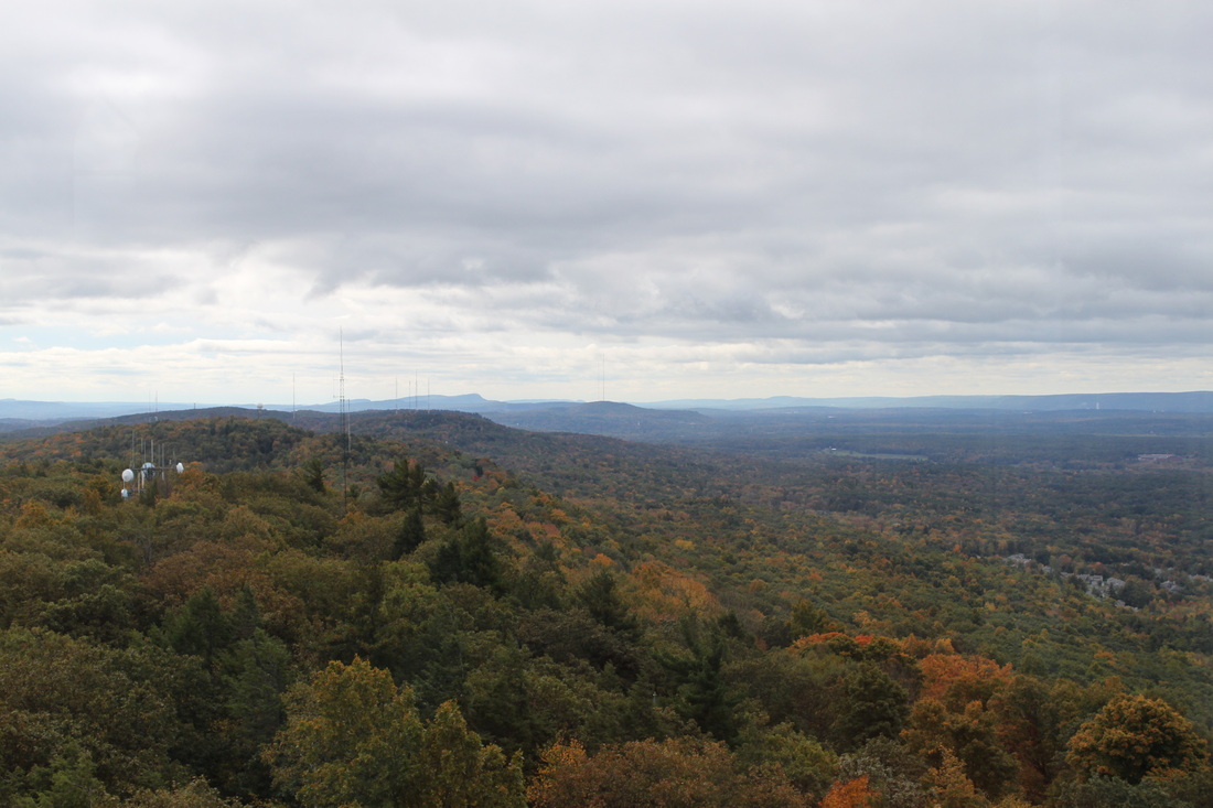
The View South (The Metacomet Ridge)
From the area around the tower, the trail heads south past the picnic tables. There is a road here, which you follow past a radio tower. Eventually, the trail leaves the road and heads back in to the woods. For the most part, the trail heads east. But, it winds left and right, up and down, and it is very rocky in sections…so watch your ankles.
Eventually, the trail comes to a T intersection with an alternate trail that heads up from Reservoir # 6. This section can be a bit tricky because it isn’t a true T. It kind of bends to the left (where there is another, unmarked trail) and I got lost for a few minutes (you’ll see my error on the MapMyHike map below...around the mile # 3 marker). So, when you get here, bear left slightly but then straighten back out before you make the hard left onto the alternate trail (marked with a blue and red blaze).
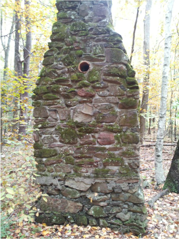
I’m still not sure if this alternate trail is required for the CT400, but it is in the CFPA Walk Book. So, I’m covering it just in case. It also makes the hike a loop. So, you won't have to re-hike over trail you've already hiked. That said, there really isn’t much to write about down here. At one point, I passed an old chimney in the middle of the woods. There are a lot of these in CT and, as cool as they are, they are equally creepy. Jaci says they are too “Blair Witch-y” for her. I think it’s cool to reflect on a simpler time, when this was someone’s cabin or farm (where there are now trees as far as the eye can see, there was once farmland). This one stands about nine feet tall, which is on the taller side of the "woods chimneys" I've seen so far...
Eventually, the trail comes to a T intersection with an alternate trail that heads up from Reservoir # 6. This section can be a bit tricky because it isn’t a true T. It kind of bends to the left (where there is another, unmarked trail) and I got lost for a few minutes (you’ll see my error on the MapMyHike map below...around the mile # 3 marker). So, when you get here, bear left slightly but then straighten back out before you make the hard left onto the alternate trail (marked with a blue and red blaze).
I’m still not sure if this alternate trail is required for the CT400, but it is in the CFPA Walk Book. So, I’m covering it just in case. It also makes the hike a loop. So, you won't have to re-hike over trail you've already hiked. That said, there really isn’t much to write about down here. At one point, I passed an old chimney in the middle of the woods. There are a lot of these in CT and, as cool as they are, they are equally creepy. Jaci says they are too “Blair Witch-y” for her. I think it’s cool to reflect on a simpler time, when this was someone’s cabin or farm (where there are now trees as far as the eye can see, there was once farmland). This one stands about nine feet tall, which is on the taller side of the "woods chimneys" I've seen so far...
Eventually, the trail heads across a power-line cut and, not too far from there, links back up with the Metacomet proper. It descends, becoming rocky again for a short stretch, and eventually leads back out to Rt. 185. I crossed the street, made my way back to the car, and drove home.