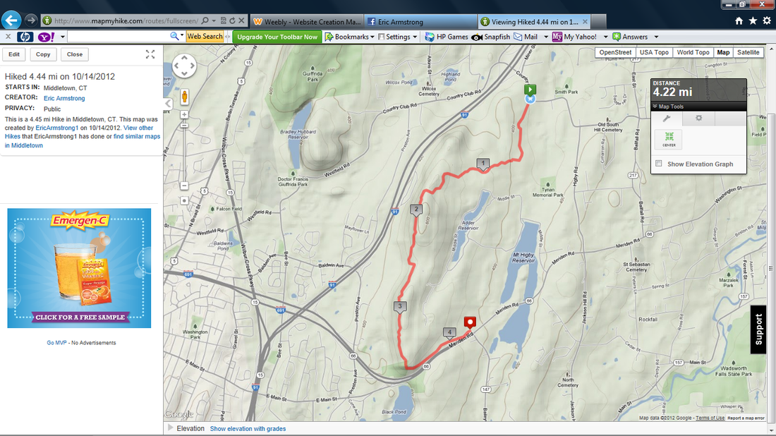
Hike #6
Trail: Mattabesett
Section: Country Club Road (Middletown, CT) to Rt. 66 (Middlefield, CT)
Distance: 4.45 miles
Approximate time to complete: 2.5 hours
Direction of Travel: North to South
Date Hiked: 10/14/2012
Date Published: 12/26/2012
Trail: Mattabesett
Section: Country Club Road (Middletown, CT) to Rt. 66 (Middlefield, CT)
Distance: 4.45 miles
Approximate time to complete: 2.5 hours
Direction of Travel: North to South
Date Hiked: 10/14/2012
Date Published: 12/26/2012
A few weeks before I got back into hiking, one of Jaci’s friends from college had expressed interest in hiking from one end of Mount Higby to the other. We discussed it briefly but nohing really took shape until after I posted the MapMyHike from my trip up to Heublein Tower on Facebook. We eventually ironed out plans and decided we would make the hike on this, the second Sunday of October.
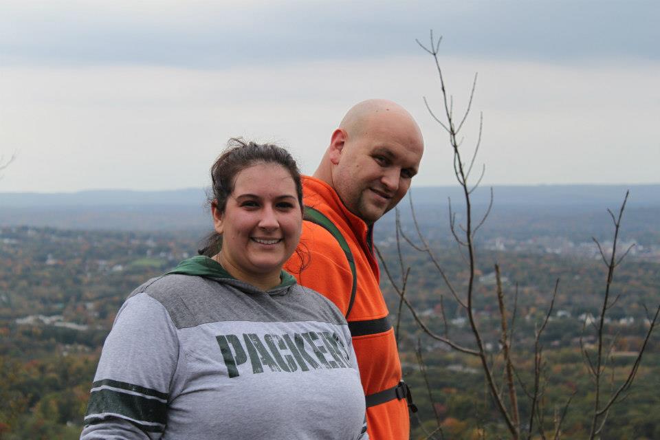
Jaci and I got up early (but not as early as we originally planned), dropped Roscoe off at PetSmart for a grooming, and drove to our friends Pam and Mark’s. Pam was staying behind to tend to their six month old baby daughter. And, I have to give credit to Jaci here. It would’ve been easy for her to stay behind with Pam but she decided to join Mark and me. Also, a quick thanks to Pam for dropping us off and picking us up at the trailheads.
The weather on this day wasn’t great, but it wasn’t bad either. It was overcast which meant the views at the top wouldn’t be as good, but it wasn’t raining (and never would) so we were thankful for that. It was also cool enough for a sweater but not cold.
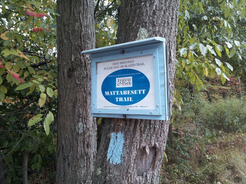
Before we set out, I explained to the party that I was slightly concerned about what we might find at the start of our hike. According to Steve over at http://www.ctmuseumquest.com/ the area around the northern trailhead had been converted to an ATV park. The pictures from his hike include several shots of fences and “Keep Out” signs the landowner felt the need to put up just off trail. Apparently, this guy had even gone to the trouble of blacking out the blue blazes on some of the telephone poles in the area. I have to laugh at that attempt to keep people off of his property since, by removing the blazes, all he did was confuse hikers and INCREASE the likelihood that they would end up on his property looking for the trail. Regardless, we were hiking the trail four years later, so I was hopeful that this “ATV business” had failed and the area had been cleaned up. And, I’m happy to report that it is. There is still some evidence of this failed venture in the area, but our experience was a lot better than Steve’s.
The trail starts climbing almost immediately, but it is a nice gradual climb for about a mile and a half. Somewhere in this stretch, there is an alternate trail, which connects the Mattabesett and Tynan Memorial Park. We were dropped off at the trail so we didn’t need to worry about parking. But, if you can’t find a spot on Country Club Road (and you aren’t concerned about the CT400), consider the park as an alternate parking location. If you are trying to do all of the CT400 mileage, but are forced to leave your car at the park instead of Country Club Road, you’ll have to return to make up the mileage you miss. No big deal, either way…just a heads up.
As you get closer to the top of the ridgeline, the trail gets steeper but it isn’t anything you can’t handle. There is also a series of switchbacks, which I’ve come to love because they allow a look back (and, in some cases, down) over the trail where you just hiked. Close to the top, I noticed several deer off in the distance and pointed them out to Mark. Jaci didn’t hear me correctly and thought I said “bear” so she had a semi freak-out and, naturally, the deer scampered off.
Somewhere close to the top of the ridgeline trail there is supposedly a side trail that leads to the wreckage of a small plane crash from the 50’s. I had never heard of it before this trip so I don’t know much about it, but we crossed paths with a gentleman later who seemed to know a lot about it. We weren’t interested in backtracking, but Mark and I agreed we would have to come back to check that out at some point. Hopefully, we’ll make our way back there and I can provide more details.
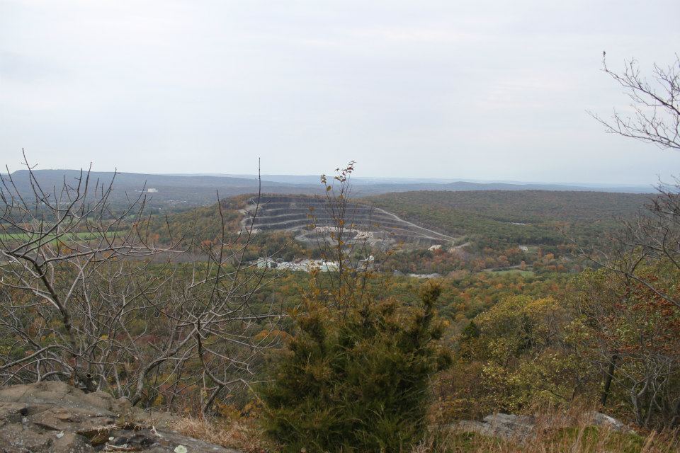
Once you reach the top of the ridge, the trail immediately offers views (which will only get better as you continue to hike) to the west. If you know the area, you can point out Lamentation Mountain and Meriden’s Hanging Hills. There is also a quarry on the east side of Lamentation Mountain and the view from the top of the ridge offers a nice view of it.
Jaci and I got up early (but not as early as we originally planned), dropped Roscoe off at PetSmart for a grooming, and drove to our friends Pam and Mark’s. Pam was staying behind to tend to their six month old baby daughter. And, I have to give credit to Jaci here. It would’ve been easy for her to stay behind with Pam but she decided to join Mark and me. Also, a quick thanks to Pam for dropping us off and picking us up at the trailheads.
The weather on this day wasn’t great, but it wasn’t bad either. It was overcast which meant the views at the top wouldn’t be as good, but it wasn’t raining (and never would) so we were thankful for that. It was also cool enough for a sweater but not cold.
Before we set out, I explained to the party that I was slightly concerned about what we might find at the start of our hike. According to Steve over at http://www.ctmuseumquest.com/ the area around the northern trailhead had been converted to an ATV park. The pictures from his hike include several shots of fences and “Keep Out” signs the landowner felt the need to put up just off trail. Apparently, this guy had even gone to the trouble of blacking out the blue blazes on some of the telephone poles in the area. I have to laugh at that attempt to keep people off of his property since, by removing the blazes, all he did was confuse hikers and INCREASE the likelihood that they would end up on his property looking for the trail. Regardless, we were hiking the trail four years later, so I was hopeful that this “ATV business” had failed and the area had been cleaned up. And, I’m happy to report that it is. There is still some evidence of this failed venture in the area, but our experience was a lot better than Steve’s.
The trail starts climbing almost immediately, but it is a nice gradual climb for about a mile and a half. Somewhere in this stretch, there is an alternate trail, which connects the Mattabesett and Tynan Memorial Park. We were dropped off at the trail so we didn’t need to worry about parking. But, if you can’t find a spot on Country Club Road (and you aren’t concerned about the CT400), consider the park as an alternate parking location. If you are trying to do all of the CT400 mileage, but are forced to leave your car at the park instead of Country Club Road, you’ll have to return to make up the mileage you miss. No big deal, either way…just a heads up.
As you get closer to the top of the ridgeline, the trail gets steeper but it isn’t anything you can’t handle. There is also a series of switchbacks, which I’ve come to love because they allow a look back (and, in some cases, down) over the trail where you just hiked. Close to the top, I noticed several deer off in the distance and pointed them out to Mark. Jaci didn’t hear me correctly and thought I said “bear” so she had a semi freak-out and, naturally, the deer scampered off.
Somewhere close to the top of the ridgeline trail there is supposedly a side trail that leads to the wreckage of a small plane crash from the 50’s. I had never heard of it before this trip so I don’t know much about it, but we crossed paths with a gentleman later who seemed to know a lot about it. We weren’t interested in backtracking, but Mark and I agreed we would have to come back to check that out at some point. Hopefully, we’ll make our way back there and I can provide more details.
Once you reach the top of the ridge, the trail immediately offers views (which will only get better as you continue to hike) to the west. If you know the area, you can point out Lamentation Mountain and Meriden’s Hanging Hills. There is also a quarry on the east side of Lamentation Mountain and the view from the top of the ridge offers a nice view of it.
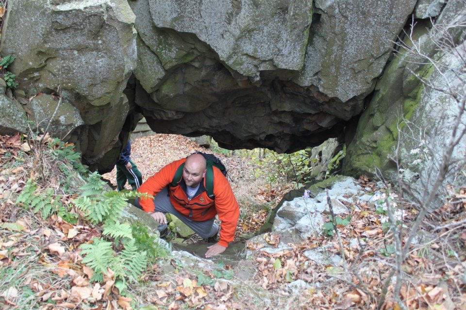
From there, the trail is a ridge walk for the next half mile or so. Mark and I took a quick minute to explore an area where there is a “Natural Bridge” and you can pass through some rocks, right off the trail. The pictures below make it look you have to complete this section in order to complete the trail. You don’t…but hiking is supposed to be fun so take a minute and enjoy it. Later, there is a section where the trail descends through the area of Preston Notch and eventually climbs back up to an area known as…wait for it…The Pinnacle. I told you there were a lot of these things in CT…so many, in fact, that I forgot about this one when writing about them in my previous re-caps.
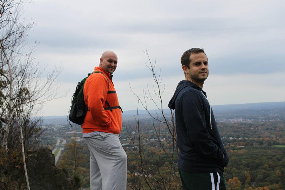
The views over the next mile or so are really nice (the main pic on this site is a panoramic style shot of the views). You are basically overlooking the area of I-91 where it intersects with 691…but you can see Beseck Mountain to the south (the next section of the Mattabesett will cover that area), the Hanging Hills and Castle Craig to the west (I will write about a hike up to Castle Craig in a future post), and a nice view to the north (which caused me to wonder if, on a clearer day, one could see downtown Hartford). If you’ve traveled through the area north on I-91, you
know the area I’m talking about it. You can see the cliff from the highway. We’ve seen it a bunch of times. As we were standing there, I reflected on how cool it was to be standing on top of a ledge I had passed in my car countless times.
know the area I’m talking about it. You can see the cliff from the highway. We’ve seen it a bunch of times. As we were standing there, I reflected on how cool it was to be standing on top of a ledge I had passed in my car countless times.
Towards the end of this section, the trail descends. The descent is quick, but it also isn’t steep (although a few sections required careful footing). That said, it isn’t nearly as gradual as the way up the other side. For a while, the descent heads directly towards Rt. 66 but it eventually swings east and runs parallel to the speeding cars (close enough to the road so you can hear them but not close enough where you need to be concerned).
This section ends in the parking lot of Guida’s, which is an old-school roadside restaurant/stand right off of Rt. 66. Again, if you are from the area, you know the place. I know of it, but I’ve never eaten there. But, they apparently have good hot dogs. We had originally planned to find out just how good the hot dogs are, but we changed plans last minute and opted for Five Guys instead. Either way, there is nothing like burning all of those calories over the course of 2.5 hours only to put them back in under 15 minutes.
This section ends in the parking lot of Guida’s, which is an old-school roadside restaurant/stand right off of Rt. 66. Again, if you are from the area, you know the place. I know of it, but I’ve never eaten there. But, they apparently have good hot dogs. We had originally planned to find out just how good the hot dogs are, but we changed plans last minute and opted for Five Guys instead. Either way, there is nothing like burning all of those calories over the course of 2.5 hours only to put them back in under 15 minutes.