From Record Highs to Record Lows
Hikes #78 & #79
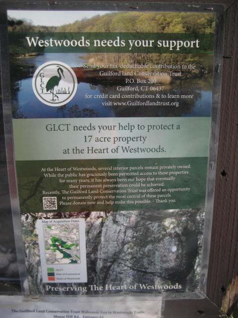
Westwoods Trails (Guilford, CT)
Distance: 4.43 Miles & 5.82 Miles
Dates Hiked: 1/4/2014 & 1/5/2014
Date Published: 1/6/2014
Hikes #78 & #79
Westwoods Trails (Guilford, CT)
Distance: 4.43 Miles & 5.82 Miles
Dates Hiked: 1/4/2014 & 1/5/2014
Date Published: 1/6/2014
Hike #78
Long-time readers of this blog might recall my hike on the trails of Stony Creek Quarry on New Year’s Day 2013, when I had a nightmare experience trying to find a suitable parking location and Roscoe got stuck at the top of a set of boulders. In that recap, I noted how confusing the trail system within Stony Creek Quarry is. Never one to back down from a challenge, I later returned (on Hike # 48) and found a good system for tackling the trails there. Now, after another 30 hikes, I was ready to put that system to another test.
On January 2nd and 3rd, Connecticut was hit by Winter Storm Hercules. And, while the snowfall in some areas wasn’t nearly as bad as predicated (East Hartford, where I live, only got about 4.5 of the predicated 9 inches), it was still going to throw a wrench in my plans for hiking this weekend. Adding to the difficulty was the fact that the temperature was predicted to hover around zero on the day of this hike. After much internal debate about where to hike and when to start, I settled starting a little later than usual and hiking in Westwoods Trails in Guilford.
Westwood Trails, which is an extensive network of trails just to the east of the Stony Creek Quarry Trails, contains over 39 miles of trails. Unlike Stony Creek Quarry, there aren’t any trails which are blazed one color while heading west and another while heading east, but there are more total trails. And, unfortunately, they use a lot of the same colors for their trails…using only different shapes to distinguish between the separate trails of the same color. This can be really confusing unless you have a map and, even if you do, it creates a mentally taxing aspect to hiking unfamiliar to most of the other trails in the CFPA Walk Book. Ultimately, I picked this location for my hikes this weekend because I figured it wouldn’t be as cold on the shoreline as it would be inland.
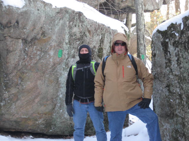
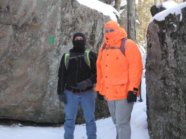
My dad has spent the last few weeks (since Thanksgiving) telling me how he wanted to start hiking with me again. Those of you familiar with my blog might recall he spent a lot of time hiking with me last winter as we completed the Nipmuck Trail end-to-end. Now that he can’t ride his Harley, he is ready to hit the trail. But, this would be his first time hiking since last April. I would’ve preferred to ease him back into it, like I did for myself when I started up again back in October…but there was nothing I could do about the snow. His friend Allan, also an avid Harley fan, would be joining us. I have to give these guys a lot of credit. If they weren’t as adamant about wanting to go on the morning of the hike, I probably would’ve stayed home where it was warm.
I wasn’t sure exactly how much snow would be on the ground in Guilford, but it was deep enough at the house where I was worried Roscoe would have trouble. So, he was going to sit this one out. I would say he enjoyed staying home where it was warm, but something tells me he would’ve preferred to be out on the trail.
I made my way with my dad and Allan, in my dad’s Toyota Tundra from my house in East Hartford to Moose Hill Road in Guilford (roughly an hour drive). We parked my dad’s truck just off road, where the Green Rectangle Trail crosses. I was familiar with this parking location because I stumbled on to it while searching for parking on my first Stony Creek hike. I even got my Dodge Charger stuck in the snow here for a few minutes, but this time the snow was no match for the four-wheel drive of my dad’s truck.
As we got out off of the car, I glanced at the outside temperature reading on my dad’s dashboard…five degrees. Although I tried to avoid it, this was going to be a record low temperature for my hikes.
We started by crossing over Moose Hill Road and following the Green Rectangle Trail to the east (note, following the Green Rectangle Trail west will lead to the Stony Creek Quarry Trails…it is the only trail which serves as a connector between the two trail networks). After a short walk downhill, we came to the first trail junction of the day...the first of many. Here the Green Rectangle Trail continues east for a stretch before heading southeast. The Violet Trail, to the right, heads due south. We decided to stay on the Green Rectangle Trail, but I made a mental note that the Violet Trail would serve as a good route back to the parking area later.
For the most part, my solution to the confusion that is Stony Creek Quarry and Westwoods is to not have a plan and make it up as I go along. I don’t suggest doing it this way until you have some experience hiking under your belt. I also wouldn’t recommend these trail networks unless you have a map. I’ve learned to put mine in a small, Ziploc bag to keep it dry and legible.
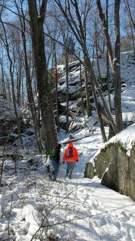
From the junction, we continued to follow the Green Rectangle Trail to the southeast. There are some neat rock formations in here. The map in the CFPA Walk Book even notes an area called “The Rift”, which I can only assume is one of the rock formations, but I’m not certain We stopped to take a few pictures around the rock formations.
On January 2nd and 3rd, Connecticut was hit by Winter Storm Hercules. And, while the snowfall in some areas wasn’t nearly as bad as predicated (East Hartford, where I live, only got about 4.5 of the predicated 9 inches), it was still going to throw a wrench in my plans for hiking this weekend. Adding to the difficulty was the fact that the temperature was predicted to hover around zero on the day of this hike. After much internal debate about where to hike and when to start, I settled starting a little later than usual and hiking in Westwoods Trails in Guilford.
Westwood Trails, which is an extensive network of trails just to the east of the Stony Creek Quarry Trails, contains over 39 miles of trails. Unlike Stony Creek Quarry, there aren’t any trails which are blazed one color while heading west and another while heading east, but there are more total trails. And, unfortunately, they use a lot of the same colors for their trails…using only different shapes to distinguish between the separate trails of the same color. This can be really confusing unless you have a map and, even if you do, it creates a mentally taxing aspect to hiking unfamiliar to most of the other trails in the CFPA Walk Book. Ultimately, I picked this location for my hikes this weekend because I figured it wouldn’t be as cold on the shoreline as it would be inland.
My dad has spent the last few weeks (since Thanksgiving) telling me how he wanted to start hiking with me again. Those of you familiar with my blog might recall he spent a lot of time hiking with me last winter as we completed the Nipmuck Trail end-to-end. Now that he can’t ride his Harley, he is ready to hit the trail. But, this would be his first time hiking since last April. I would’ve preferred to ease him back into it, like I did for myself when I started up again back in October…but there was nothing I could do about the snow. His friend Allan, also an avid Harley fan, would be joining us. I have to give these guys a lot of credit. If they weren’t as adamant about wanting to go on the morning of the hike, I probably would’ve stayed home where it was warm.
I wasn’t sure exactly how much snow would be on the ground in Guilford, but it was deep enough at the house where I was worried Roscoe would have trouble. So, he was going to sit this one out. I would say he enjoyed staying home where it was warm, but something tells me he would’ve preferred to be out on the trail.
I made my way with my dad and Allan, in my dad’s Toyota Tundra from my house in East Hartford to Moose Hill Road in Guilford (roughly an hour drive). We parked my dad’s truck just off road, where the Green Rectangle Trail crosses. I was familiar with this parking location because I stumbled on to it while searching for parking on my first Stony Creek hike. I even got my Dodge Charger stuck in the snow here for a few minutes, but this time the snow was no match for the four-wheel drive of my dad’s truck.
As we got out off of the car, I glanced at the outside temperature reading on my dad’s dashboard…five degrees. Although I tried to avoid it, this was going to be a record low temperature for my hikes.
We started by crossing over Moose Hill Road and following the Green Rectangle Trail to the east (note, following the Green Rectangle Trail west will lead to the Stony Creek Quarry Trails…it is the only trail which serves as a connector between the two trail networks). After a short walk downhill, we came to the first trail junction of the day...the first of many. Here the Green Rectangle Trail continues east for a stretch before heading southeast. The Violet Trail, to the right, heads due south. We decided to stay on the Green Rectangle Trail, but I made a mental note that the Violet Trail would serve as a good route back to the parking area later.
For the most part, my solution to the confusion that is Stony Creek Quarry and Westwoods is to not have a plan and make it up as I go along. I don’t suggest doing it this way until you have some experience hiking under your belt. I also wouldn’t recommend these trail networks unless you have a map. I’ve learned to put mine in a small, Ziploc bag to keep it dry and legible.
From the junction, we continued to follow the Green Rectangle Trail to the southeast. There are some neat rock formations in here. The map in the CFPA Walk Book even notes an area called “The Rift”, which I can only assume is one of the rock formations, but I’m not certain We stopped to take a few pictures around the rock formations.
When we came to the second trail junction of the day (with the Yellow Rectangle Trail), I decided we should make a right and follow the Yellow Rectangle Trail due south (the Green Rectangle Trail continues due east). Again, I was only making this up as I went along but the same thing that makes this trail network so confusing also makes it open for many loop possibilities. I suspect I’ll be able to get a few more un-planned hikes in down here before I need to look at specific trails in order to limit the amount of “doubling up” I do.
The Yellow Rectangle Trail follows at the lower edge of a small ridge due south for a stretch before it comes to a power-line cut. Note the track which follows the cut, which is usually reserved for utility and maintenance work, is another trail, the Red Triangle Trail. We crossed over the Red Triangle Trail and came to another junction. Here, the Blue Rectangle Trail and the Yellow Rectangle Trail join for a short distance. Eventually, the Blue Rectangle Trail breaks off and heads east. We stayed on the Yellow Rectangle Trail, still heading southeast.
We weren’t on the Yellow Rectangle Trail for very long when we all started to feel the weight of the snow on our boots. If you’ve ever hiked in snow before, you know how much more challenging it is than hiking in dry conditions. If you usually pack up your hiking gear for the winter months, I encourage you to try toughing it out just one time. It is extremely challenging, but it is also a lot of fun and the untouched areas of snow on top of rock is something I won’t even attempt to describe…as my words would only comes up short. We were fortunate in that we were the first people to travel most of these trails since the snowfall a couple of days earlier.
Staying on the Yellow Rectangle Trail, we passed an area on the map called “Great Fallen Cliff” on our way to Lost Lake. I think I know exactly what the map is referring to, and it is impressive. Once we reached the overlook of Lost Lake, we had a couple of options.
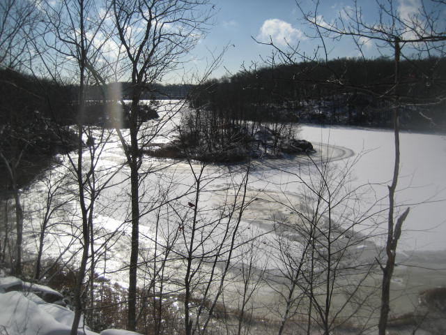
The Yellow Rectangle, Yellow Circle, and White Circle trails all converge in the area of the overlook. We opted for the Yellow Circle Trail, which would bring us to the southernmost junction of the Violet Circle Trail…and that trail could eventually lead us back to the truck. Before any of that, however, we had to navigate a pretty steep descent to get down off of the ridge we were on.
The Yellow Circle Trail took us down near the edge of Lost Lake. We struggled along the way, not only because it was a steep descent, but because it was difficult to tell exactly what was good footing and what was not with the layer of snow on top of the rocks. Slowly but surely, we made our way down…now heading due west. After a few ups and downs, the trail bends to the right and starts heading northwest.
After some time, most of which was spent climbing uphill only to descend again, we came to the south junction of the Violet Trail. Here, the Yellow Circle Trail makes a right but the two trails will eventually run parallel to one another. I was tired of looking at Yellow Blazes (Rectangle and/or Circle) so we opted to follow the Violet Trail and begin our journey back to the truck. Along the way, however, I got sidetracked and mistakenly took the Pink Trail (which I wasn’t aware even existed…I just thought it was a different shade of “Violet”…did I mention these trails are confusing?). It wasn’t until we ended up at a separate parking location off of Moose Hill Road that I realized the error of my ways.
Luckily, I had a map and we could compare it to a larger version at the parking location, so I quickly figured out a way back to the Violet Trail. From the parking location, we followed the Blue Rectangle Trail due west and hooked back up with the Violet trail after a short walk. We made a left and followed the Violet Trail due north. Before long, we were crossing over the Red Triangle Trail and, later, we reached the junction with the Green Rectangle Trail. We made a left, retraced our steps along the Green Rectangle Trail, and made our way back to the truck.
On the way home, we stopped by a local Harley dealer so my dad and Allan could shop. I took advantage of the pit stop and bought a shirt for myself. I’m not as Harley-obsessed as these guys…I just wanted something dry because I knew we would soon be making the drive over to New Haven for some pizza at Modern Apizza.
If you aren’t familiar with the area, I feel sorry for you. New Haven, Connecticut has…the…best…pizza…in the world. This isn’t even open for debate. The only thing which is debatable is which place in New Haven is truly the best…Pepe’s, Sally’s, or Modern. Everyone in the area has their favorite…and, to be honest, you really can’t go wrong at any of the three. We Armstrongs just have a strong preference for Modern. This was the best post-hike meal I ever had.

For a map of this hike, along with elevation data, please click here.
Hike #79
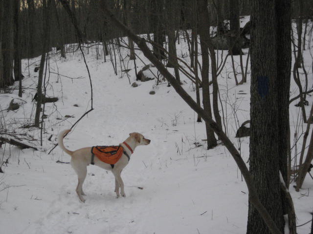
The following day, Allan had a previous commitment and my dad was still recovering (I don’t blame him…I was pretty tired myself) so it was just me…except that, on our hike the day before, I realized the snow wasn’t that deep…so the best hiker on four paws would be joining me.
The temperature on this day wasn’t as cold as the five degrees of a day earlier. But, at twelve degrees, it was still colder than my previous coldest (fourteen degrees). Adding to the “misery”, later, I would experience a brief shower of freezing rain, which caught me by surprise since I hadn’t seen it in the forecast.
After learning of the larger parking location on Moose Hill Road the day before, I decided it would make sense to use that location for this hike. It is a little longer of a drive (by maybe only a minute), but the lot is larger and seems to be used more often. When I arrived, there were several tire tracks in the snow from other visitors the day before, which made it easier to park and not worry about if I could get out later. I geared up, got Roscoe out of the car, and we hit the trail.
I started by taking the Blue Rectangle Trail. Since I had spent most of the previous day covering small sections of each trail, I wanted to pick a trail and cover it end to end. Also, since the Blue Rectangle Trail heads east to another parking location (on the other side of Westwoods, off of Dunk Rock Road), it would give me an opportunity to scout the parking there in case I wanted to use it on future trips.
Heading west on the Blue Rectangle Trail, I crossed the Violet Circle Trail, hooked up with the Yellow Rectangle Trail for a stretch, hooked up with the Red Triangle Trail for a stretch, crossed the White Circle Trail, crossed the Orange Circle Trail, crossed the Green Circle Trail, passed the Green Triangle trail, and eventually made my way to the Dunk Rock Road parking location.
Here, I doubled back and retraced my steps until I came to the Green Triangle Trail. I made a right and followed that trail to the north, knowing it would eventually swing back to the south and put me right back on the Blue Rectangle Trail. When I finally made it back to the Blue Rectangle Trail, I quickly made another right and followed the Green Circle Trail, which converges with the other two trails in the same area.
The Green Circle Trail would turn out to be the most challenging trail of the day. None of these trails are overly challenging from the stand point of long, steep climbs but the short climbs they do lead the hiker on can be technically challenging at times…as I found out with Roscoe the hard way last year around this same time. The snow only added to the challenge. But, we made our way for what seemed like an eternity…climbing up and down…swinging right and left…until we finally came to the northernmost section of Westwoods, where I found the White Circle Trail.
I made a slight right turn on the White Circle Trail and followed that until I reached yet another parking location, off of Peddlers Road. I doubt I’ll ever use this parking location since I ended up covering all of the trails in this area, but it is here so I’m including in this recap for informational purposes.
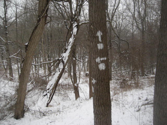
Once I reached the parking area off of Peddler’s Road, I doubled back and retraced my steps for a bit until I reached the White Square Trail. I don’t know who had the idea to put these two (White Circle and White Square) trails in the same area of the park, but I don’t think it was a wise one. Look at the picture below and tell me you can see the difference between the white square blaze and the white circle blaze.
Once I reached the parking area off of Peddler’s Road, I doubled back and retraced my steps for a bit until I reached the White Square Trail. I don’t know who had the idea to put these two (White Circle and White Square) trails in the same area of the park, but I don’t think it was a wise one. Look at the picture below and tell me you can see the difference between the white square blaze and the white circle blaze.
Again, I was lucky enough to have a map…but good luck to you if you come here without one. The maps at each parking location are helpful when you first arrive, but you’ll want something to help you navigate all of the different trail junctions and intersections.
I made a right on the White Square Trail and followed that until I came back to the White Circle Trail. By making another right, I could follow the White Circle Trail southeast. But, I had one more short section to hike in order to close the loop on this White Square/White Circle mess. So, I did that…doubled back…and followed the White Circle (now making a left) to the “Plank Walk”.
The “Plank Walk” is something I first noticed on the map at the parking location off of Peddlers Road. I knew there was a huge marsh here, (the Green Circle Trail goes way out of the way to avoid it) so the White Circle Trail was probably going to involve walking on 2x4s. But, the idea of a “Plank Walk” had me talking to myself in pirate voice for the rest of this hike…savvy?
I followed the White Circle Trail over the “Plank Walk” and past a junction with the Yellow Circle Trail and Orange Circle Trail. After the junction of the three trails, the White Circle Trail heads uphill to the top of a small ridge. It was strange to find a ridge walk so close to Long Island Sound but the trail followed it for quite a bit. If I were the first person to travel this trail in a few days, I would’ve gotten lost. There aren’t many trees and the blazes are few and far between. Fortunately, someone else had gone before me so I just followed their footprints. I found them to be quite reliable.
I stayed on the White Circle Trail as it crossed over the Green Rectangle Trail and a different White Square Trail (from what I can tell, the White Rectangle Trail to the far north is not connected to the White Square Trail in this central area of Westwoods…and this central area of the trail doesn’t connect to another White Square Trail in the section of Westwoods to the far south…this trail network is so strange).
To round out my hike, I made my way back to the Blue Rectangle Trail, made a right (heading west), and followed that back to my car.
More than ten miles of hiking over two days this weekend taught me the best way to deal with complicated trail networks is to do some “on-the-ground” research. The map looks so confusing but clarity is provided once you start hiking and familiarize yourself with the area. One tip I have is to make a copy of the map and highlight over the trails you walk as you go. If you are like me and you prefer to plan out your hikes ahead of time, this method will make you crazy. But, so far I’ve found it is the best plan of attack. And, I plan to use it on future hikes in Westwoods.
For a map of this hike, along with elevation data, please click here.
Total 2014 Distance: 23.10 Miles
