Tight Squeeze
Hike # 85
Westwoods Trails (Guilford, CT)
Distance: 5.66 Miles
Date Hiked: 1/25/2014
Date Published: 1/27/2014
I’ve been slowly working my way through the multitude of trails within Westwoods in Guilford. This area has become my “go-to” in the winter months because I have the feeling it is a mess in the spring/summer. There is a lot of water down this way and my assumption is that this area is a breeding-ground for mosquitoes. So, with the recent snowfall we received, I thought I would head back down to Guilford and bang out a few more miles.
I didn’t go out of my way to get up early, which is rare for me when I hike. Roscoe has been nursing a wounded dew claw so he was sitting this hike out. And, I wanted to make sure he still got some exercise in…but I didn’t feel like waking up at 5am to take him for a walk in the freezing cold. In short, by the time I parked off of Moose Hill Road to begin this hike, it was already after 9am.
I started by following the Blue Rectangle Trail for about 2/10 a mile until I reached the Violet Circle Trail. I made a right and followed the Violet Trail, covering steps I originally intended to cover with my dad and Allan on our trip through Westwoods three weeks earlier. You may recall, on that trip, we diverted from the Violet Trail and ended up on the Pink Trail (which isn’t in the Walk Book). This time around, I continued following the Violet Trail (heading due south) until I reached the Yellow Circle Trail.
From what I’ve seen so far, the Yellow Circle Trail is easily the most technically challenging trail within Westwoods. That’s not too say it is on the same level as some of the more challenging trails I’ve done outside of Westwoods, but it is pretty tough…and I was surprised to find something so challenging this close to the shoreline. And, the challenging nature of it explains why the trail looks less travelled than the other trails…apparently the good people of the Guilford/Branford area know something I don’t.
I started my journey along the Yellow Circle Trail by making a left from the Violet Circle Trail. Now heading due north, I climbed and clambered up/over several rock formations, all while overlooking the Yellow Square Trail at the base of the cliff below. I was excited to be climbing on top of some of the cooler rock formations I was standing at the base of three weeks prior. If I could do it all again, I would do the Yellow Square Trail one way and the Yellow Circle Trail back in the same day. If you are looking for a neat adventure, I would make that suggestion…for whatever its worth.
Eventually, I made my way so far back to the north I met back up with the Blue Rectangle Trail. Here, after a pretty steep descent, the Yellow Circle Trail shares some distance with the Blue Rectangle and Yellow Square trails (the trees are blazed for all three trails). I continued to follow the Yellow Circle Trail north, crossing a large power line cut, and coming to a rather steep switchback/scramble up the side of a fairly good-sized cliff.
I previously encountered this cliff three weeks ago when I thought I had led my dad and Allan off trail. As it turns out, since we were following the Yellow SQUARE trail that day, I hadn’t taken them the wrong way. I had to double check a few times to make sure the Yellow Circle trail actually went up the side of this cliff (the trail is pretty narrow, looks more like a spot for water to run off, and there is some overgrowth of thorny bushes). Eventually, I made my way from the power line cut at the base off the cliff to overlooking the top of the power lines from the top of the cliff. This was a pretty fun, yet tiring, climb…especially in the snow. Once I reached the top, I paused a few moments to catch my breath and then continued following the trail north.
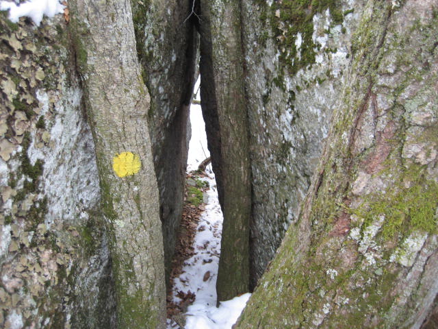
After a short while, I came to an interesting section where the blazes indicated I should crawl on my hands and knees and squeeze my way through a narrow section created by two boulders. I can’t say what I would’ve done if conditions were dry, but I wasn’t motivated to crawl and squeeze with the ground covered in snow. So, I went around. In my defense, I wasn’t the only person to go around. There were several other tracks in the snow. And, I’m not sure I would’ve fit anyway. Maybe if I lose another 70 pounds I’ll give it another try someday. For now, I made sure to double back to the “exit” of the squeeze and took this picture.
Hike # 85
Westwoods Trails (Guilford, CT)
Distance: 5.66 Miles
Date Hiked: 1/25/2014
Date Published: 1/27/2014
I’ve been slowly working my way through the multitude of trails within Westwoods in Guilford. This area has become my “go-to” in the winter months because I have the feeling it is a mess in the spring/summer. There is a lot of water down this way and my assumption is that this area is a breeding-ground for mosquitoes. So, with the recent snowfall we received, I thought I would head back down to Guilford and bang out a few more miles.
I didn’t go out of my way to get up early, which is rare for me when I hike. Roscoe has been nursing a wounded dew claw so he was sitting this hike out. And, I wanted to make sure he still got some exercise in…but I didn’t feel like waking up at 5am to take him for a walk in the freezing cold. In short, by the time I parked off of Moose Hill Road to begin this hike, it was already after 9am.
I started by following the Blue Rectangle Trail for about 2/10 a mile until I reached the Violet Circle Trail. I made a right and followed the Violet Trail, covering steps I originally intended to cover with my dad and Allan on our trip through Westwoods three weeks earlier. You may recall, on that trip, we diverted from the Violet Trail and ended up on the Pink Trail (which isn’t in the Walk Book). This time around, I continued following the Violet Trail (heading due south) until I reached the Yellow Circle Trail.
From what I’ve seen so far, the Yellow Circle Trail is easily the most technically challenging trail within Westwoods. That’s not too say it is on the same level as some of the more challenging trails I’ve done outside of Westwoods, but it is pretty tough…and I was surprised to find something so challenging this close to the shoreline. And, the challenging nature of it explains why the trail looks less travelled than the other trails…apparently the good people of the Guilford/Branford area know something I don’t.
I started my journey along the Yellow Circle Trail by making a left from the Violet Circle Trail. Now heading due north, I climbed and clambered up/over several rock formations, all while overlooking the Yellow Square Trail at the base of the cliff below. I was excited to be climbing on top of some of the cooler rock formations I was standing at the base of three weeks prior. If I could do it all again, I would do the Yellow Square Trail one way and the Yellow Circle Trail back in the same day. If you are looking for a neat adventure, I would make that suggestion…for whatever its worth.
Eventually, I made my way so far back to the north I met back up with the Blue Rectangle Trail. Here, after a pretty steep descent, the Yellow Circle Trail shares some distance with the Blue Rectangle and Yellow Square trails (the trees are blazed for all three trails). I continued to follow the Yellow Circle Trail north, crossing a large power line cut, and coming to a rather steep switchback/scramble up the side of a fairly good-sized cliff.
I previously encountered this cliff three weeks ago when I thought I had led my dad and Allan off trail. As it turns out, since we were following the Yellow SQUARE trail that day, I hadn’t taken them the wrong way. I had to double check a few times to make sure the Yellow Circle trail actually went up the side of this cliff (the trail is pretty narrow, looks more like a spot for water to run off, and there is some overgrowth of thorny bushes). Eventually, I made my way from the power line cut at the base off the cliff to overlooking the top of the power lines from the top of the cliff. This was a pretty fun, yet tiring, climb…especially in the snow. Once I reached the top, I paused a few moments to catch my breath and then continued following the trail north.
After a short while, I came to an interesting section where the blazes indicated I should crawl on my hands and knees and squeeze my way through a narrow section created by two boulders. I can’t say what I would’ve done if conditions were dry, but I wasn’t motivated to crawl and squeeze with the ground covered in snow. So, I went around. In my defense, I wasn’t the only person to go around. There were several other tracks in the snow. And, I’m not sure I would’ve fit anyway. Maybe if I lose another 70 pounds I’ll give it another try someday. For now, I made sure to double back to the “exit” of the squeeze and took this picture.
I continued on the Yellow Circle Trail, still heading north, over some rocky terrain. A couple of times, I found myself putting my backside on the ground and sliding down an incline or two. I’m sure this stuff isn’t overly challenging in anything other than snow. This was actually a lot of fun….I felt like a kid again.
Eventually, I met up with the Yellow Square Trail again and, after crossing it, came to another boulder crawl/squeeze. This one was probably less of a crawl and less of a squeeze than the last one, but I still felt a little too much “Big Guy” going on for me to be able to squeeze through. So, once again, I followed the foot traffic around the rock formation. Again, I doubled back to get a picture and…at the exact moment my camera flashed…I saw something move from right to left across the screen. At first, I thought I was going to need to change my pants, but then I realized it was only a squirrel. Then, I got excited thinking maybe I caught him/her mid jump…but, as it turns out…by the time the camera took the picture, the squirrel had landed on the other side of the rocks. Thankfully, you can still see a bushy tail in the top left corner of the picture below.
Eventually, I met up with the Yellow Square Trail again and, after crossing it, came to another boulder crawl/squeeze. This one was probably less of a crawl and less of a squeeze than the last one, but I still felt a little too much “Big Guy” going on for me to be able to squeeze through. So, once again, I followed the foot traffic around the rock formation. Again, I doubled back to get a picture and…at the exact moment my camera flashed…I saw something move from right to left across the screen. At first, I thought I was going to need to change my pants, but then I realized it was only a squirrel. Then, I got excited thinking maybe I caught him/her mid jump…but, as it turns out…by the time the camera took the picture, the squirrel had landed on the other side of the rocks. Thankfully, you can still see a bushy tail in the top left corner of the picture below.
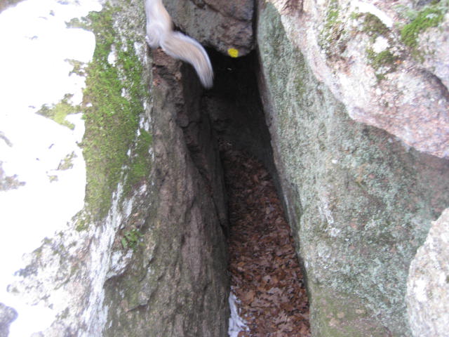
Obviously, this wasn’t THAT exciting. I mean…I see probably five squirrels a day when I walk Roscoe. I just thought it was cool that it jumped from one side of the “squeezer” to the other as I was snapping the photo.
Moving on, I continued following the Yellow Circle Trail northbound until I reached its northern terminus. Here, the trail intersects with the White Circle Trail (just to the south of the “Plank Walk” I mentioned in my last recap) and the Orange Circle Trail. Since I had already covered the White Circle Trail in this section, I opted to follow the Orange Circle Trail.
Moving on, I continued following the Yellow Circle Trail northbound until I reached its northern terminus. Here, the trail intersects with the White Circle Trail (just to the south of the “Plank Walk” I mentioned in my last recap) and the Orange Circle Trail. Since I had already covered the White Circle Trail in this section, I opted to follow the Orange Circle Trail.
The very first steps on the Orange Circle Trail head pretty much straight uphill. It is a short hill, but a hill nonetheless. Also, after encountering a few technical sections…with more rock climbing/boulder squeezing…I believe I’ve cracked the code of Westwoods. I plan to do more research before I commit 100%, but I think the circle trails are more challenging and follow the top of the cliffs…and the square trails are less challenging and follow the base of the cliffs. To build on the thought, the triangle trails, are probably the least challenging of the system. Nothing against the triangle trails, but last time through here, I saw a woman reading a book while walking on the Green Triangle trail…so there ya go.
I continued following the Orange Circle Trail (heading south), passing the Orange Square Trail (a couple of times), the Green Rectangle Trail, the Blue Rectangle Trail, and the Red Diamond Trail. As I approached the area of Three Corners Road, I encountered a red crossover trail…but elected to continue on the Orange Circle Trail through an interesting rock formation/descent. Once at the bottom, I came to an intersection with the Red Triangle Trail. I would eventually enjoy an easy stroll along the Red Triangle Trail as I started to wrap up the day, but I first had to climb up the same hill I just descended and make my way out to Three Corners Road. Once, I reached the road, I turned around (going back down the same hill) and followed the Red Triangle Trail for a bit.
Eventually I made my way back across the power line cut which divides Westwoods into north and south. Back on the north side, I encountered the Blue Rectangle Trail and followed that back to my car. All told, I did 5.66 miles of hiking and I think I’ve narrowed the network down to maybe three more hikes...two if I’m ambitious. I hope to finish those up before it gets too soggy down this way…we’ll see.
When I got home from this hike, I ran some quick calculations and realized I hiked more than 100 miles between 12/25 and 1/25. I was kind of shocked by that. I knew it was a lot, but I was thinking maybe it was somewhere between 70 and 80. I never imagined it would be over 100 miles. I wonder how long it will take me before I pass my total for 2013.
For a map of this hike, along with elevation data, please click here.
Total 2014 Distance: 67.59 Miles
