Three-For-All
Hikes #55, #56 and #57
Trail Network: McLean Game Refuge (Granby, CT and Simsbury, CT)
Dates Hiked: 10/5/2013, 10/6/2013 and 10/12/2013
Date Published: 10/12/2013
Hikes #55, #56 and #57
Trail Network: McLean Game Refuge (Granby, CT and Simsbury, CT)
Dates Hiked: 10/5/2013, 10/6/2013 and 10/12/2013
Date Published: 10/12/2013
For the start of the 2013-2014 hiking season, I wanted to find something that would allow me to ease my way back into hiking. I haven’t exactly been sitting still since I last hiked…in fact, I’ve spent the last four weeks or so running 4 miles every other day during the week, lifting weights on the off days during the week, walking the dog every day, and biking on most weekends…but I’ve come to find there is a stark contrast between being in better physical condition and being in good hiking condition. So, my goal was to find something in my new (okay, somewhat still new) Walk Book West which would provide for some good fall hiking…and not kick my butt too much. Eventually, I decided on the McLean Game Refuge.
From the Walk Book: McLean Game Refuge is a privately owned and privately operated wildlife sanctuary established in 1932 by the will of Senator George P. McLean. It consists of more than 4,200 acres of forests, fields, and streams, and includes the easternmost traprock ridge summit of the Barndoor Hills.
The refuge is also located roughly 30 minutes from where I live, making it the closest of the hiking trails described in the Walk Book West. So, it was a no-brainer for me to hit this up first. The only items left to figure out were who was coming with me and how would I tackle this network of trails.
A few weeks after I planned out these hikes, the company I work for announced a “Get Active!” competition. We had such an overwhelming response from the people on our floor that we ended up with two teams of 11 people…and yours truly became captain of one of those teams. Since I was supposed to be motivating people to get out and be more active, I thought what better way than to invite my team to come along on the first hike. Based on the description in the walk book, I expected the first day to be a good hike for beginners. The initial response from my colleagues was pretty good (as it usually is) but, as it turned out, only a couple of people showed (as they usually do). But, it was the first hike of the season and I wasn’t going to let other people’s non-committal attitude bring me down. Also, Jaci was going to come so that was nice. And, of course, the best hiker on four paws would be joining the group…as our self-appointed scout.
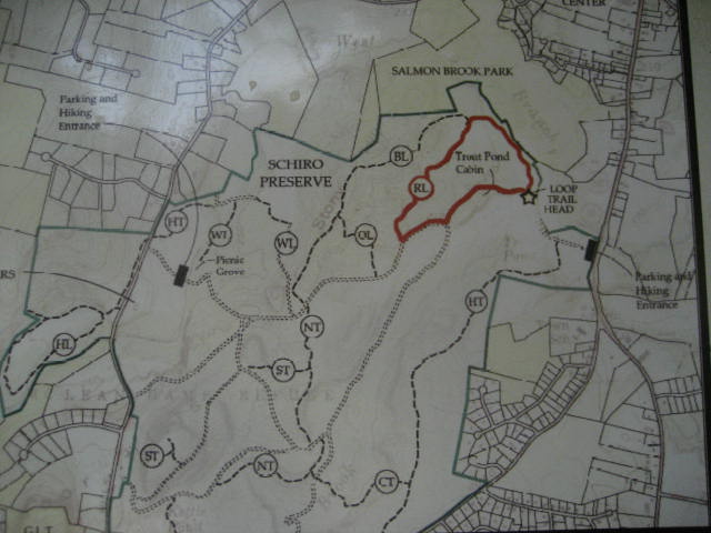
The trails within McLean Game Refuge aren’t overwhelming, but I definitely suggest planning ahead and bringing a map because they can be a little misleading if you aren’t prepared. To begin with, there are three loop trails (Red, Orange, and Blue) and they all start and end together…but, somewhere along the way, someone had the idea to have them separate at different locations throughout the refuge. So, while the entire blue trail loop covers a total of 2.07 miles, the red trail will eventually branch off (forming its own, smaller loop of 1.25 miles) and, later still, the orange trail will also branch off (forming its own loop of 1.9 miles). Sound confusing? That’s because it is. Hopefully the picture below will help (note: BL is Blue Loop, RL is Red Loop, etc.). Also, note that the Walk Book describes all three loops. So, if you are looking to officially complete the CT400, you have to cover them all.
From the Walk Book: McLean Game Refuge is a privately owned and privately operated wildlife sanctuary established in 1932 by the will of Senator George P. McLean. It consists of more than 4,200 acres of forests, fields, and streams, and includes the easternmost traprock ridge summit of the Barndoor Hills.
The refuge is also located roughly 30 minutes from where I live, making it the closest of the hiking trails described in the Walk Book West. So, it was a no-brainer for me to hit this up first. The only items left to figure out were who was coming with me and how would I tackle this network of trails.
A few weeks after I planned out these hikes, the company I work for announced a “Get Active!” competition. We had such an overwhelming response from the people on our floor that we ended up with two teams of 11 people…and yours truly became captain of one of those teams. Since I was supposed to be motivating people to get out and be more active, I thought what better way than to invite my team to come along on the first hike. Based on the description in the walk book, I expected the first day to be a good hike for beginners. The initial response from my colleagues was pretty good (as it usually is) but, as it turned out, only a couple of people showed (as they usually do). But, it was the first hike of the season and I wasn’t going to let other people’s non-committal attitude bring me down. Also, Jaci was going to come so that was nice. And, of course, the best hiker on four paws would be joining the group…as our self-appointed scout.
The trails within McLean Game Refuge aren’t overwhelming, but I definitely suggest planning ahead and bringing a map because they can be a little misleading if you aren’t prepared. To begin with, there are three loop trails (Red, Orange, and Blue) and they all start and end together…but, somewhere along the way, someone had the idea to have them separate at different locations throughout the refuge. So, while the entire blue trail loop covers a total of 2.07 miles, the red trail will eventually branch off (forming its own, smaller loop of 1.25 miles) and, later still, the orange trail will also branch off (forming its own loop of 1.9 miles). Sound confusing? That’s because it is. Hopefully the picture below will help (note: BL is Blue Loop, RL is Red Loop, etc.). Also, note that the Walk Book describes all three loops. So, if you are looking to officially complete the CT400, you have to cover them all.
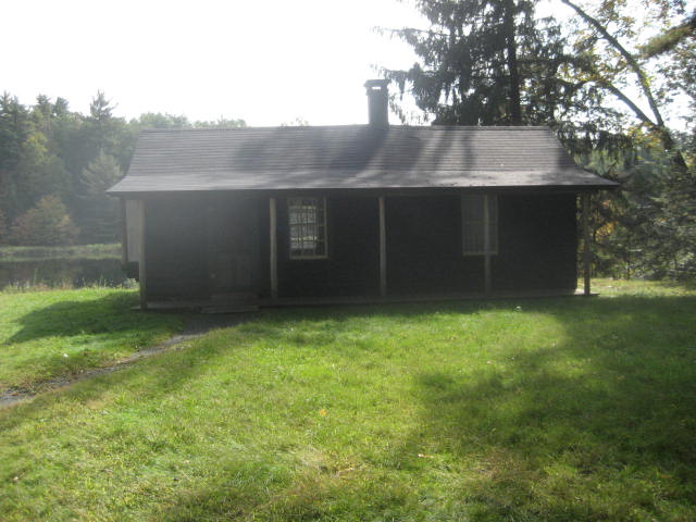
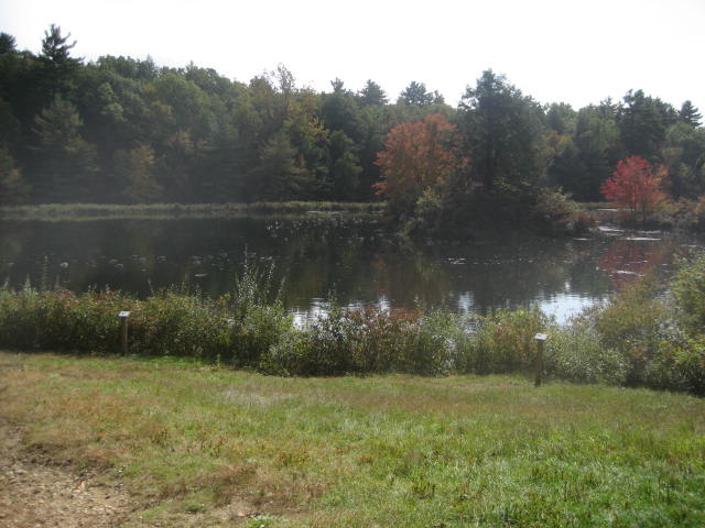
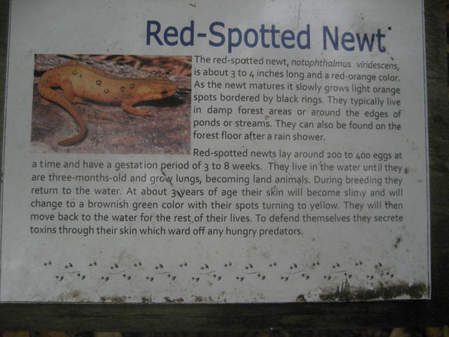
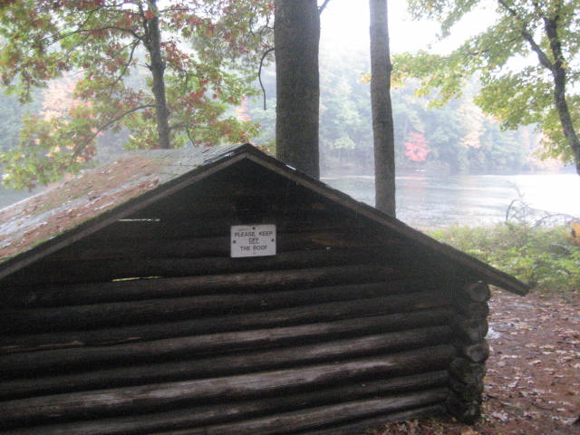
No matter how you plan to tackle the loop trails, you will encounter what I considered to be the highlight of the non-hiking related items on the first day. Along the Blue, Red, Orange loop trails is Senator McLean’s Cabin. The cabin, which is not open to the public, is situated on a small hill overlooking Trout Pond. Take a moment or two to look through the cabin windows and reflect on the simpler times. Also, take a moment to read the informational plaques along the edge of the pond. You’ll never know what you might learn…particularly about the “islands” in the middle of the pond.
|
|
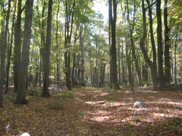
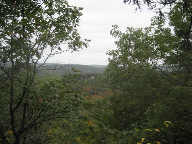
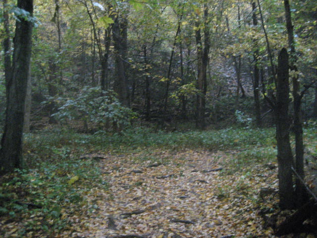
For my hikes, and for this recap, I broke the entire refuge into three sections. What I’m calling the Northeast Section (including the loop trails) was hiked on the first day, which was pretty much a perfect fall day. The leaves, which are starting to change all over the area, were extremely colorful…and, occasionally, one would slowly make its way down to the forest floor. If it were just a little cooler, I would say it was perfect…but near perfect was far better than what I dealt with on the second day. As Roscoe and I (just man and dog this time) made our way through what I’m calling the Central Region, we did so in a pouring rain storm. The local meteorologists promised it would taper off throughout the day. I can assure you it did not…but, as usual, we made the most of it. He got particularly excited towards the end of this second hike…which was an interesting contrast to my mounting frustration due to said rainfall. The third and final day, which covered the region I'm calling the Western Region, was absolutely perfect.
All in all, based on what I was looking for in terms of how to ease back into hiking season, McLean Game Refuge was the perfect place.
Northeast Region
Parking access to this region of the refuge is as straightforward as it gets. There is a large parking area (for maybe 20 to 30 cars) located off of Routes 10 and 202 in Granby. From the parking area, there is a paved road (gated off) which leads west and eventually comes to a woods road. Follow the woods road for a bit and eventually it leads to a small bridge over a stream. Shortly after the bridge crossing, on the right-hand side of the woods road, is the entrance for the loop trails. At this point, the trees are all blazed Red, Orange, and Blue. Also, the blazes are horizontal…not the standard vertical to which I’ve grown so accustomed.
Red Loop Trail (1.25 Miles)
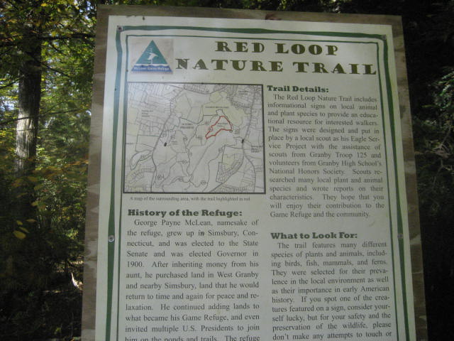
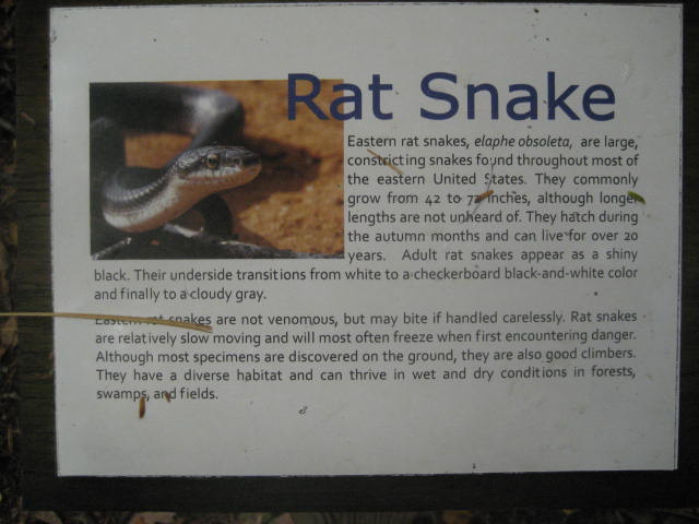
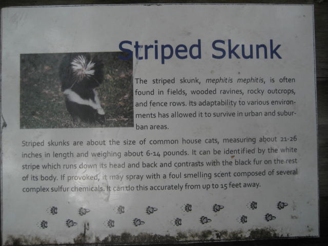
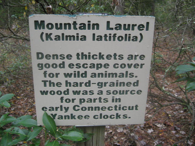
The Red Trail is far and away the easiest trail in the entire refuge. Deemed the “Nature Trail” by a few of the signs in the area, this trail is perfect for beginners. There aren’t many elevation changes and, those that are there, are gradual. They even have an assortment of informational plaques stationed throughout.
All in all, based on what I was looking for in terms of how to ease back into hiking season, McLean Game Refuge was the perfect place.
Northeast Region
Parking access to this region of the refuge is as straightforward as it gets. There is a large parking area (for maybe 20 to 30 cars) located off of Routes 10 and 202 in Granby. From the parking area, there is a paved road (gated off) which leads west and eventually comes to a woods road. Follow the woods road for a bit and eventually it leads to a small bridge over a stream. Shortly after the bridge crossing, on the right-hand side of the woods road, is the entrance for the loop trails. At this point, the trees are all blazed Red, Orange, and Blue. Also, the blazes are horizontal…not the standard vertical to which I’ve grown so accustomed.
Red Loop Trail (1.25 Miles)
The Red Trail is far and away the easiest trail in the entire refuge. Deemed the “Nature Trail” by a few of the signs in the area, this trail is perfect for beginners. There aren’t many elevation changes and, those that are there, are gradual. They even have an assortment of informational plaques stationed throughout.
|
|
|
|
Orange Loop Trail (1.9 Miles)
The Orange Trail is slightly more challenging than the Red Trail. Gone are the informational plaques, there are a few more elevation changes (though not much…and not even remotely challenging for expert hikers), and they are less gradual than before. There is even a section of this trail, where it is still connected with the Blue Trail, which summits Stony Hill (380 feet). I only point it out because the Walk Book does. You could probably summit this thing and never realize you covered something worthy of an elevation mention. All the same, I added it to my peaks list because…well, because that’s what lists are for.
Blue Loop Trail (2.07 Miles)
The Blue Trail is an interesting trail. I would say that it is the most challenging of the loop trails, but this distinction doesn’t mean…by any stretch…it is actually challenging. In fact, a good majority of this trail is the same woods road which will eventually lead back to the parking lot off of 10 and 202. The woods road is mostly flat and mostly straight, so that portion is really easy. The section of the Blue Trail, after the other trails have branched off so it is only Blue Trail, is nice and it provided for a nice lead in to some of the hiking we would do later on the first day.
North Trail (2.4 Miles)
From the main woods road that makes up the southern part of the loop trails the North Trail branches off to the left and begins by heading due south. The section of the North Trail within the Northeast Region was pretty easy. My original plan was to follow this to the Summit Trail, but the Summit Trail is not blazed and…unless you know what to look for…you’ll never find it (more on that in a bit). The North Trail (Purple Blazed) connects the woods road which is part of the loop trails to Barndoor Hills Road. Over the course of the first two days, I spent most of my time on this trail and, as a result, grew very fond of it. It is generally hilly, with a few very short climbs thrown in for good measure. True beginners will find it a little more challenging in here, but we were travelling with someone in our group who developed blisters and was able to push through these hills/climbs without a single complaint. We did however, eventually turn around and I saved a portion of the North Trail for the second day...but this was my plan all along.
Summit Trail (0.7 Miles)
The Summit Trail was like the Holy Grail of the trails within the refuge. I thought I knew its exact location and we even hiked the first section of it for about 50 feet before we turned back because there weren’t any blazes. Only later, when we ended up back on the trail after turning on to a different (also unmarked) trail, did I realize we should’ve just kept going on what I thought was the original trail. Looking back at CT Museum Quest after the hike, I realized I should have been looking for the red ribbon tied to the branch of a tree. We actually did see the ribbon but I didn’t realize that was the correct trail. I should have consulted CT Museum Quest first (next time, I will). In summary, look for the ribbon and you’ll be fine.
The Summit Trail follows what looks like a woods road, but eventually turns to a single-wide path and then, near the end, turns right off of what looks like the trail and heads up to the summit of the easternmost hill of the Barndoor Hills (580 feet). This was the only category 5 climb we did on the first day. You should also note that there is no sign, or even a blaze, signaling the turn which leads up to the actual summit…you are just supposed to know that the trail heading off to the right, up the rocky incline, is the right one. Hopefully the force is strong with you.
|
|
Central Region
Parking access to this region can be found on either Barndoor Hills Road or Firetown Road. I elected to park on Barndoor Hills Road. There is a dirt parking area near the intersection of Barndoor Hills Road and Simsbury Road which is big enough for maybe 10 cars. Just know that if you park on Barndoor Hills, the trails for what I’m calling the Central Region will be mostly to the west…where as if you park on Firetown Road, the trails for the Central Region are all to the east.
North Trail (2.4 Miles)
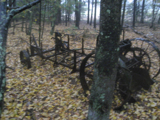
I covered most of this trail on the first day (and earlier in this recap), while hiking the Northeast Region of McLean…but there was some leftover for the second, rain-soaked day. The section of trail closer to Barndoor Hills Road is hillier than the section closer to the loop trails. There is a large meadow off the trail just a bit and, as we approached this area, I noticed the remnants of what looks like an old tractor.
Parking access to this region can be found on either Barndoor Hills Road or Firetown Road. I elected to park on Barndoor Hills Road. There is a dirt parking area near the intersection of Barndoor Hills Road and Simsbury Road which is big enough for maybe 10 cars. Just know that if you park on Barndoor Hills, the trails for what I’m calling the Central Region will be mostly to the west…where as if you park on Firetown Road, the trails for the Central Region are all to the east.
North Trail (2.4 Miles)
I covered most of this trail on the first day (and earlier in this recap), while hiking the Northeast Region of McLean…but there was some leftover for the second, rain-soaked day. The section of trail closer to Barndoor Hills Road is hillier than the section closer to the loop trails. There is a large meadow off the trail just a bit and, as we approached this area, I noticed the remnants of what looks like an old tractor.
There is a side trail off of the North Trail in this section which leads to what the walk book describes as “Spring Pond Cabin” (more on that in a bit). For me, the worst part of this hike was the section where the trail comes to a T junction and there is no blaze signaling which way to turn. Because I had somewhat lost my bearings in the rain...and because this is still early hiking season…I made the mistake of going to the left and added some distance to my trip. In a way this worked out because I had added mileage to my planned hike the day before (which removed it from my second hike) so this “mistake” added back in the extra mileage I was going to miss. I laughed at myself later when I realized my mistake, turned around to go the other way, and found that I wasn’t too far from where we had left off the day before. For your reference, when you come to the intersection you see below, make a right to stay on the North Trail.
Once I reached the point where we had turned around the day before, I turned around and headed back towards the car. We still had plenty of hiking to do to the west of the Barndoor Hills parking location, but not before I explored the “Spring Pond Cabin”.
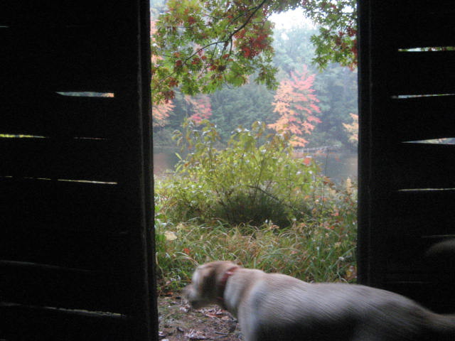
The “Spring Pond Cabin” is basically a wooden cabin with a roof…one room (about 8x6), didn’t have a fireplace/chimney, and I had to duck to get in (note: I’m 6’3” but I suspect anyone who is over 4 feet tall would have to duck to get in this thing). The cabin, which overlooks Spring Pond, barely has enough room for three people to lie down. Our king size mattress at home probably wouldn’t fit in it. I’ve seen tents bigger than this thing. Okay, you get the point. But, I will say this…it was nice to get out of the rain for a moment. I even debated waiting here until the rain let up…but, in the end, I decided not to linger. Good thing, too…because the rain didn’t let up for several hours.
The “Spring Pond Cabin” is basically a wooden cabin with a roof…one room (about 8x6), didn’t have a fireplace/chimney, and I had to duck to get in (note: I’m 6’3” but I suspect anyone who is over 4 feet tall would have to duck to get in this thing). The cabin, which overlooks Spring Pond, barely has enough room for three people to lie down. Our king size mattress at home probably wouldn’t fit in it. I’ve seen tents bigger than this thing. Okay, you get the point. But, I will say this…it was nice to get out of the rain for a moment. I even debated waiting here until the rain let up…but, in the end, I decided not to linger. Good thing, too…because the rain didn’t let up for several hours.
|
|
Eventually, we made our way back to the car…passed right by it…and started along the…
Firetown Trail (1.7 Miles)
The Firetown Trail is an interesting one. It starts immediately to the west of the Barndoor Hills parking location and runs generally east/west to Firetown Road (where, again, there is a second parking location). But the first section can be a bit tricky. For starters, it begins as Purple Blazed…which makes me wonder if this isn’t just an extension of the North Trail (in fact, the maps on the website for the refuge seem to indicate it is still the North Trail…so the Walk Book is wrong?). Either way, the first section of this trail ascends quickly to some high ground along Simsbury Road. There is even a bit of a switchback here. After this ascent the trail descends to pass along a meadow and then re-ascends as soon as it leaves the meadow. This was the first thing which resembled the hiking I did over the winter in the two days I’d been out here. Roughly a third of a mile in, you will come to this strange-looking blaze, which signals the end of the Purple Blazes and the start of the Gray Blazes.

At this point, you can go right (west) and follow the trail for 1.4 miles out to Firetown Road or you can go left (east) and follow the trail for 0.1 miles back to Barndoor Hills Road. Either way, I wasn’t sure if the section to the east was required so I made a left turn and covered it anyway. If you aren’t obsessed with the CT400 you don’t need to worry about this piece…there really isn’t much to see. Eventually, I made my way out to Barndoor Hills Road, doubled back, reached the intersection again, and continued straight (following the trail out to Firetown Road). The remaining sections of this trail were mostly nice…with some hilly pieces…but, by this time, I was only focused on how wet everything was. The rain looked like it would let up a few times, only to have it start to downpour again.
A couple of other frustrating things to note, the gray blazes are really hard to pick up at points, especially in the rain…but the trail seemed to be well travelled and is easy enough to follow. That is, when you aren’t turning randomly right and left because of the “Private Property/Trail” signs that make up a good chunk of the middle of this trail. Along the way (about a third of a mile from Firetown Road), we passed the East Loop Trail on our right.
Once we reached Firetown Road, I made a right and made a short road walk before hooking back up with East Loop Trail.
East Loop Trail (1.25 Miles)
I wasn’t originally planning to cover this trail (as it’s not required for the CT400) but I figured I was already wet so why not…either that or I was delirious from being pelted with rain for two straight hours. In the end, I’m glad I decided to cover it. This turned out to be the only category 5 climb of the second day, even though some of the other sections on my second day hike felt equally as “rugged”. The trail (which is Blue Blazed) would eventually lead us back to the Firetown Trail and we would follow that back to the car.
Western Region
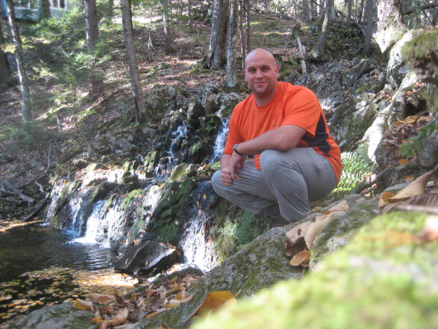
The Western Region of McLean, which I hiked along with a couple of people from work and Roscoe on the third day, is by far and away the most rugged. The parking location we used (off of Firetown Road in Simsbury) has enough room for three cars and sits at around 525 feet elevation. Our hike through the area would climb to 936 feet, back down to almost as level as the parking area, and then climb again to 870 feet. Around the 870 foot mark, the trail we were on was barely recognizable and it was covered with pretty thick brush. I had also heard stories of bears in the area…so, we kept our eyes peeled, but never saw any. Also, before you begin any hiking in the area, I suggest following the short trail directly across from the parking location, which heads west from Firetown Road. There is a neat little waterfall not too far from the road.
A couple of other frustrating things to note, the gray blazes are really hard to pick up at points, especially in the rain…but the trail seemed to be well travelled and is easy enough to follow. That is, when you aren’t turning randomly right and left because of the “Private Property/Trail” signs that make up a good chunk of the middle of this trail. Along the way (about a third of a mile from Firetown Road), we passed the East Loop Trail on our right.
Once we reached Firetown Road, I made a right and made a short road walk before hooking back up with East Loop Trail.
East Loop Trail (1.25 Miles)
I wasn’t originally planning to cover this trail (as it’s not required for the CT400) but I figured I was already wet so why not…either that or I was delirious from being pelted with rain for two straight hours. In the end, I’m glad I decided to cover it. This turned out to be the only category 5 climb of the second day, even though some of the other sections on my second day hike felt equally as “rugged”. The trail (which is Blue Blazed) would eventually lead us back to the Firetown Trail and we would follow that back to the car.
Western Region
The Western Region of McLean, which I hiked along with a couple of people from work and Roscoe on the third day, is by far and away the most rugged. The parking location we used (off of Firetown Road in Simsbury) has enough room for three cars and sits at around 525 feet elevation. Our hike through the area would climb to 936 feet, back down to almost as level as the parking area, and then climb again to 870 feet. Around the 870 foot mark, the trail we were on was barely recognizable and it was covered with pretty thick brush. I had also heard stories of bears in the area…so, we kept our eyes peeled, but never saw any. Also, before you begin any hiking in the area, I suggest following the short trail directly across from the parking location, which heads west from Firetown Road. There is a neat little waterfall not too far from the road.
Westledge Trail (1.7 Miles)
The Westledge Trail (which the Walk Book says is pink blazed but looks more purple blazed to me) starts by following along Firetown Road for about a tenth of a mile. It also shares its beginning with the Eddy Loop Trail (more on that trail later). It eventually turns left down a private driveway (No Parking) but only follows this for a short stretch before entering the woods. Around the quarter mile mark, the Eddy Loop Trail turns off to the right and the Westledge Trail starts to climb. I was expecting the trail to climb more steeply than it does. But, it is pretty much all climb for about the next mile or so. The Walk Book declares this area as “Garrett Stairs” but we were hard pressed to find anything that resembled stairs. We did, however, come across the remains of a small 17th century agricultural village which was known as Pilfershire. There were plenty of long rock walls and a couple of cellar holes. Here the trail flattens out for the next half mile or so and eventually leads to Highridge Road. Along the way, we reached the highest point in all of McLean Game Refuge (936 feet). Once we reached the road, we turned around and made our way back down to…
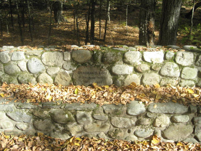
Eddy Loop Trail (2.5 Miles)
The Eddy Loop Trail (named for Deborah B. Eddy, who was a McLean Trustee from 1971 to 1994) is easily my favorite trail in the refuge. I wasn’t expecting anything close to the climb we experienced and I was surprised at how much more challenging the climb to 870 feet was when compared to the climb to 936 feet. The trail (White Blazed) also starts along Firetown Road. Before it branches off from the Westlege Trail, it comes to this stone bench, dedicated to Deborah B. Eddy...
The Westledge Trail (which the Walk Book says is pink blazed but looks more purple blazed to me) starts by following along Firetown Road for about a tenth of a mile. It also shares its beginning with the Eddy Loop Trail (more on that trail later). It eventually turns left down a private driveway (No Parking) but only follows this for a short stretch before entering the woods. Around the quarter mile mark, the Eddy Loop Trail turns off to the right and the Westledge Trail starts to climb. I was expecting the trail to climb more steeply than it does. But, it is pretty much all climb for about the next mile or so. The Walk Book declares this area as “Garrett Stairs” but we were hard pressed to find anything that resembled stairs. We did, however, come across the remains of a small 17th century agricultural village which was known as Pilfershire. There were plenty of long rock walls and a couple of cellar holes. Here the trail flattens out for the next half mile or so and eventually leads to Highridge Road. Along the way, we reached the highest point in all of McLean Game Refuge (936 feet). Once we reached the road, we turned around and made our way back down to…
Eddy Loop Trail (2.5 Miles)
The Eddy Loop Trail (named for Deborah B. Eddy, who was a McLean Trustee from 1971 to 1994) is easily my favorite trail in the refuge. I wasn’t expecting anything close to the climb we experienced and I was surprised at how much more challenging the climb to 870 feet was when compared to the climb to 936 feet. The trail (White Blazed) also starts along Firetown Road. Before it branches off from the Westlege Trail, it comes to this stone bench, dedicated to Deborah B. Eddy...
The only real complaint I have about this trail is that, after it ascends to 870 feet, it descends back to Firetown Road. And, as a result, the final three quarters of a mile to mile of this trail is a road walk. It felt like a sad ending for such a great trail. Of course, you can walk the trail in the opposite direction…which would make the road walk the first part of your hike, but then you wouldn’t get to experience the great climb which I think defines this trail. Hopefully, in the future, someone will find a way to make this trail connect back in through the woods...eliminating the road walk piece.
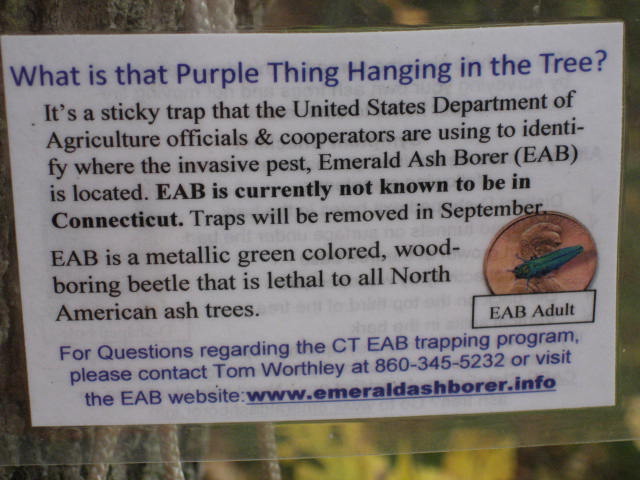
On the road walk back to the car, we did notice a purple triangle contraption suspended in the air. At first, I thought it was a bat house. As it turns out, it is a sticky trap used by the United States Department of Agriculture to study Emerald Ash Borer.
On the road walk back to the car, we did notice a purple triangle contraption suspended in the air. At first, I thought it was a bat house. As it turns out, it is a sticky trap used by the United States Department of Agriculture to study Emerald Ash Borer.

|
|
Over the course of these three days, I really enjoyed my time spent in McLean Game Refuge. Now that I’ve logged the first 23+ miles of the fall, I’m ready for a bigger adventure. My next several hikes will cover Sleeping Giant State Park and, as most of you know; I’ve been building up to this one for a long time. I’ve got my hikes all planned out, and I’m ready to start my journey towards becoming a Giant Master. It might be a while before I post another recap (as I’m planning to recap all of the trails once I’ve covered them all), but know that I am out there enjoying the fall weather in New England.
Distance to 2013 Goal: 154.56
Distance to 2013 Goal: 154.56
