Wind-whipped
Hikes #66 & # 67
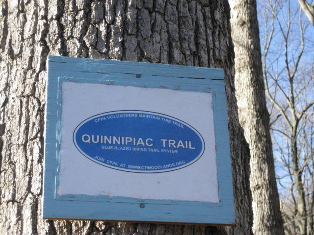
Trail: Quinnipiac Trail
Sleeping Giant State Park to Regicides Trail (Out and Back…11/23/2013)
YMCA Camp Laurel to Regicides Trail (Out and Back…11/24/2013)
Date Published: 11/25/2013
Hikes #66 & # 67
Trail: Quinnipiac Trail
Sleeping Giant State Park to Regicides Trail (Out and Back…11/23/2013)
YMCA Camp Laurel to Regicides Trail (Out and Back…11/24/2013)
Date Published: 11/25/2013
Hike # 66
The weekend of November 23rd and 24th was a windy one here in Connecticut. I started my weekend by taking Roscoe for an early morning walk around our neighborhood on Saturday. He was still recovering from a minor procedure on his foot so he wouldn’t be hiking with me and I wanted to make sure he still got in some exercise. As I was walking with him, I realized I was going to need my gloves.
Later, around 9:00am, I met Tim and Monika at the main parking lot within Sleeping Giant State Park. All week we debated hiking the Blue Trail. I had already done it but they wanted to see it. I was willing to do it again, but only if conditions weren’t too bad from the rain we got the day before. When we arrived at the lot, we still weren’t sure if the trail would be too slippery. So, we decided to check out the section of the Blue Trail in the western section of the park.
From the main lot, we made our way over to the Violet Trail and followed that for a bit, heading due North through what the Sleeping Giant Park Association calls Section I. When we came to the intersection with the Blue Trail, we followed that for a bit. I had previously travelled this section of the Blue Trail only one week earlier, and I knew this section would give us a good indicator for the other sections. If the leaves and rocks in this section were too wet, Tim and Monika would probably have to save their journey along the Blue Trail for another day. After our assessment, I didn’t think it would be too bad. But, in the end, the group decided the rocks were too wet and we opted for a less challenging hike. Considering someone fell one week earlier near the section we were planning to hike, I think we made the right decision.
Turning away from the Blue Trail, we made our way back to Mount Carmel Avenue and eventually out to Whitney Avenue (Route 10). Heading west out of the park, we followed the Blue Blazes past a bus stop and across Whitney Avenue…making good use of a cross walk…
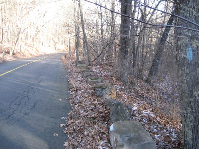
The first 4/10 of a mile or so of the Quinnipiac Trail outside of Sleeping Giant is a road walk, starting with West Woods Road (up the hill in the picture above) and turning left to head further uphill on Kimberly Road. Eventually, the trail makes a right turn off of Kimberly Road and enters the woods near the Quinnipiac University satellite campus called York Hill. Later, on the way back through the area, I noticed several towers near the campus which seemed to be swaying wildly in the wind. As it turns out, these are called “wind spires” (like a windmill, but not the typical three-pronged approach) and the university installed them as part of an alternative energy initiative. I don’t usually get caught up in the alternative energy bit, but I thought these were pretty cool.
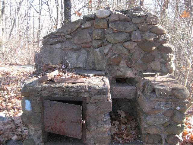
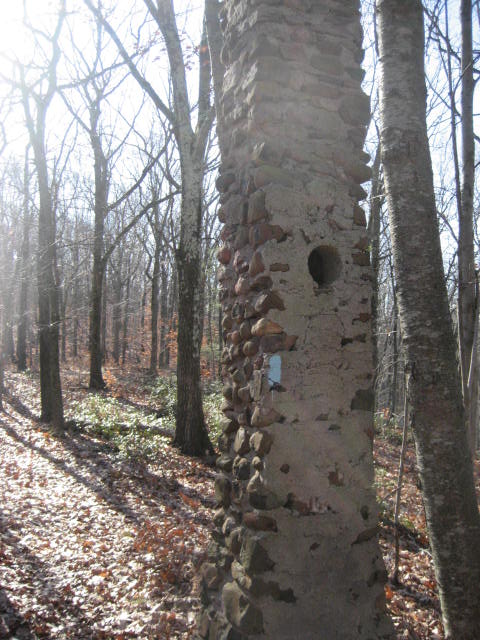
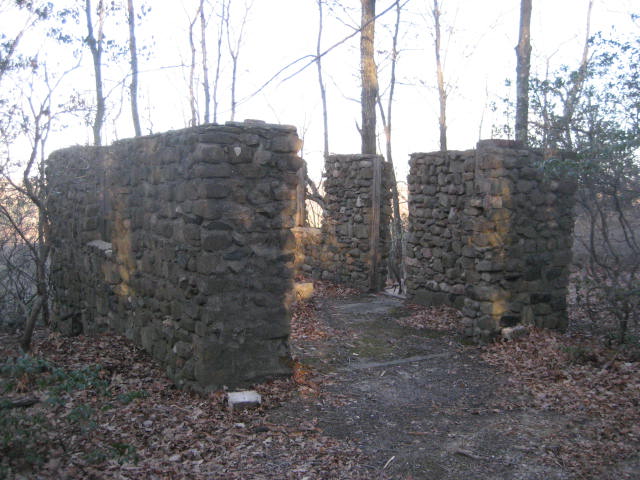
Around the same area, the trail passes by a foundation of an old cabin. I grabbed a couple of photos…
Around the same area, the trail passes by a foundation of an old cabin. I grabbed a couple of photos…
|
|
About a mile from the Sleeping Giant parking lot, the trail crosses an area which the Walk Book refers to as Rocky Top. The whole time we were in this area the University of Tennessee fight song was in my head, but I managed to keep it to myself. The Walk Book notes some views to the south and east from up here but they looked seasonal to me and there isn’t too much to see…a couple of large farms were the highlight for us.
Next, the trail descends from Rocky Top (over the course of about three quarters of a mile) and then makes a right on Rocky Top Road. We noted a really small house in the area. Not to make fun of anyone’s living situation, but it looked like there was more room in their one car garage than the actual house itself.
The trail then follows a series of roads over the next 4/10 of a mile, including Shepard Avenue, Nolan Road, and Old Coach Highway. At around the two and a quarter mile (total distance from the lot in Sleeping Giant) mark, the trail turns left from Old Coach Highway and re-enters the woods.
The next section of the trail (which heads northwest at this point) was interesting in that there were several side trails leading to and from people’s backyards and, somehow, somebody had gotten a truck back here at one point. Whoever they were, they were less fortunate in getting the truck out and now it just sits there...right off trail. Eventually, the trail comes to a woods road and makes a left. The woods road later becomes Paradise Avenue and there is an alternate parking location which isn’t mentioned in the Walk Book. The trail continues to follow Paradise Avenue for a short while before turning right and re-entering the woods.
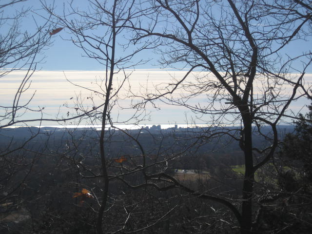
From Paradise Avenue, the trail continues west and ascends to York Mountain…which, at 680 feet, isn’t the tallest of mountains…but, at the time, it was the highest elevation I’d experienced along this trail outside of the Stone Tower in Sleeping Giant. There are also some nice views of downtown New Haven. Over the last several weeks, I’d been enjoying pretty much this same view of New Haven but getting closer to it in the process.
Next, the trail descends from Rocky Top (over the course of about three quarters of a mile) and then makes a right on Rocky Top Road. We noted a really small house in the area. Not to make fun of anyone’s living situation, but it looked like there was more room in their one car garage than the actual house itself.
The trail then follows a series of roads over the next 4/10 of a mile, including Shepard Avenue, Nolan Road, and Old Coach Highway. At around the two and a quarter mile (total distance from the lot in Sleeping Giant) mark, the trail turns left from Old Coach Highway and re-enters the woods.
The next section of the trail (which heads northwest at this point) was interesting in that there were several side trails leading to and from people’s backyards and, somehow, somebody had gotten a truck back here at one point. Whoever they were, they were less fortunate in getting the truck out and now it just sits there...right off trail. Eventually, the trail comes to a woods road and makes a left. The woods road later becomes Paradise Avenue and there is an alternate parking location which isn’t mentioned in the Walk Book. The trail continues to follow Paradise Avenue for a short while before turning right and re-entering the woods.
From Paradise Avenue, the trail continues west and ascends to York Mountain…which, at 680 feet, isn’t the tallest of mountains…but, at the time, it was the highest elevation I’d experienced along this trail outside of the Stone Tower in Sleeping Giant. There are also some nice views of downtown New Haven. Over the last several weeks, I’d been enjoying pretty much this same view of New Haven but getting closer to it in the process.
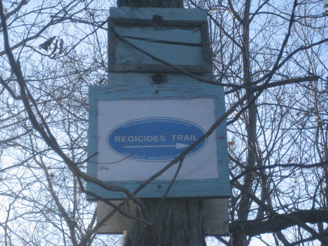
From the viewpoint, we followed the trail westward for another tenth of a mile until we reached the intersection with the Regicides Trail (3.5 miles from the Sleeping Giant lot)…
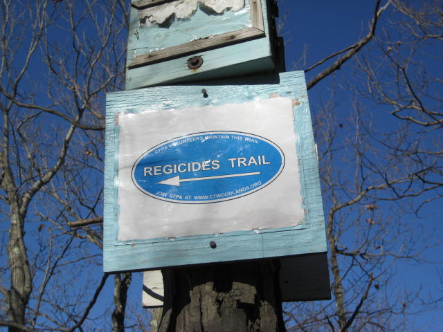
From here, the Regicides Trail heads due south for seven miles through West Ridge State Park. The Quinnipiac Trail continues west and then north for about 10.5 miles to Route 68 in Prospect. We had already covered a good amount of trail in addition to the 3.5 miles from the lot, so we decided this was a good turn around point. We made our way back to the cars.
Hike # 67
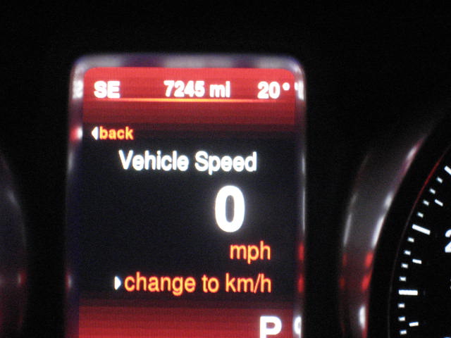
The following day, the forecast called for 30 degrees (it was actually 20 degrees when I started my hike at 6:30am) and wind gusts up to 40 MPH (this morning the reports said the gusts were close to 50 MPH). So, I packed up my winter gear for the next section of the trail.
Hike # 67
The following day, the forecast called for 30 degrees (it was actually 20 degrees when I started my hike at 6:30am) and wind gusts up to 40 MPH (this morning the reports said the gusts were close to 50 MPH). So, I packed up my winter gear for the next section of the trail.
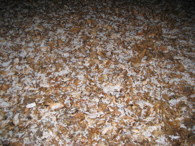
I parked near YMCA Camp Laurel, on Downs Road, and made my way (by myself) due south along the trail back to The Regicides Trail, where we turned around a day earlier. There is plenty of parking on the side of Downs Road just before the entrance to the camp. When I got out of the car, I noticed there was still a dusting a snow…which had accumulated overnight.
Heading south would go against my plan to experience the trails as they were laid out, but at the time this made the most sense. Only later did I discover there is an alternate parking location near the Sanford Feeder of the Regicides Trail, which would’ve allowed me to connect to the Quinnipiac where I had left off the day before and travel the trail northbound. Oh well…live and learn.
The first mile or so of this section follows Downs Road due south. The neighborhood along the stretch of the road to the south of the intersection with Gaylord Mountain Road is noticeably newer than the neighborhood to the north. As I approached the last house before the trail enters the woods, a dog started barking. It was before 7:00am on a Sunday and, knowing how ticked I would be if the shoe was on the other foot, I was worried I had just set off someone’s “alarm clock”…my apologies to the people of the Downs Road neighborhood.
Once the trail enters the woods, it makes a slight left turn and heads southeast for a stretch. It will eventually swing back towards the road (now dirt) and follows the same general route for the next couple of miles. Fortunately, the trail is far enough away from the road and is anything but straight so that you probably wouldn’t even know it was following the road until you looked at a map of the surrounding area. Over the course of those two miles, the trail crosses a gas pipeline cut (1.8 mile mark) and a power line cut (2.3 mile mark), it passes by a massive radio tower which I think is visible from the Stone Tower on Sleeping Giant (2.6 mile mark), and it passes the foundation of an old cabin with views to the west (2.7 mile mark). It also crosses from the town of Hamden to Bethany, back to Hamden and back to Bethany again...although, again, you would need a map to tell you that...since there is no way of knowing it as you travel along the trail.

|
|
Along the way, the trail gradually ascends to the summit of Mad Mare’s Hill (3.2 mile mark). At an elevation of 720 feet, Mad Mare’s Hill is the second highest point along the Quinnipiac Trail (second only to Mount Sanford). Sadly, the only view from Mad Mare’s Hill is that of the ridge to the southeast, which is where the trail leads. In order to get to that area of the trail, I would have to start by descending steeply to Brooks Road.
On the other side of Bethany Gap from Mad Mare’s Hill, the trail climbs back up to the top of the ridge, ascending about 300 feet in roughly half of a mile. Once near the top, the trail follows the ridgeline. There are some really nice views to the south (including New Haven again). After about 4.3 miles of hiking through the wind and cold, I reached my destination…the intersection with the Regicides trail.
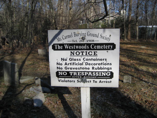
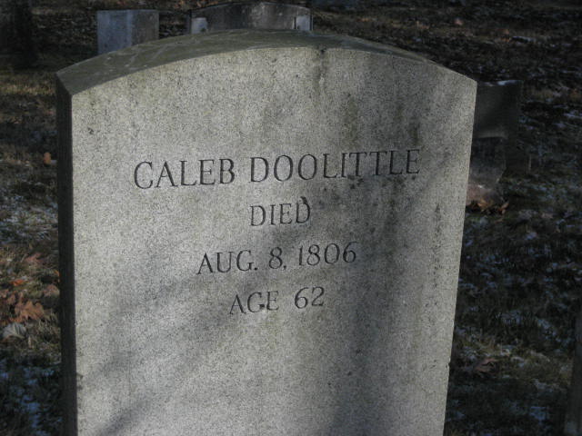
As I had done the day before, I turned and made my way back along the trail until I reached my car. On the way back, I stopped to check out Westwood Cemetery, which is just off trail near the intersection of Downs Road and Gaylord Mountain Road. This cemetery is very old. One of the headstones is for Caleb Doolittle and, while it doesn’t reference a date of birth, it does indicate he died in 1806 at the age of 62…which means he lived through the American Revolution.
|
|
I’m sure there are people who wonder why I get up early on the weekends and spend my free time frozen to the bone while hiking through a state which, seemingly, doesn’t have a lot to offer for hikers. To these people, I say that Westwood Cemetery is only one of the reasons. Our tiny little state has so much history which people have pretty much forgotten about and I really enjoy the discovery of it all.
Distance to 2013 Goal: 80.43
Distance to 2013 Goal: 80.43
